Potato Hills South
Campground · Oklahoma · 20 bookable sites ·
Managed by the US Army Corps of Engineers
CLO Lands (School Lands) · Restricted Access
- 20
- Bookable sites
- 84 ft
- Max rig length
- up to 100
- People per site
- 2
- Accessible sites
- 577 ft
- Elevation
Overview
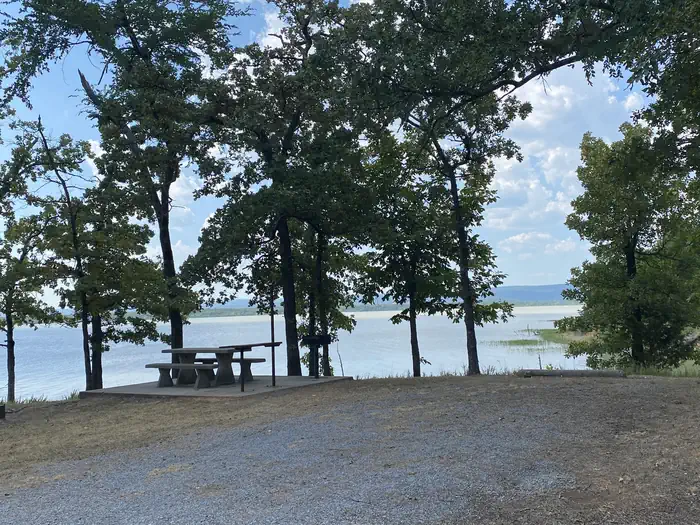
Located on the shoreline of Sardis Lake in beautiful southeast Oklahoma, Potato Hills South Campground offers outdoor recreation activities for all interests, whether its water sports in the expansive lake or hiking in the nearby Quachita Mountains.Recreation
Sardis Lake is known for its fishing, producing several of Oklahoma's largest species of bass. Fishing enthusiasts can also expect to catch crappie, catfish and walleye.Boating, water sports and hiking top the list of recreational opportunities at the lake.
Facilities
Boat ramps are available for visitors, as well as a picnic area and playground that provide an ideal setting for parties or family get-togethers.Natural Features
Sardis Lake is a reservoir fed by the waters of Jackfork Creek, a tributary of the Kiamichi river in the scenic foothills of the Ouachita Mountains.Hunters and wildlife enthusiasts will enjoy visiting the public hunting and wildlife propagation areas near Sardis Lake, which have been set aside on more than 8,000 acres of undeveloped land.
Nearby Attractions
Additional camping is also available at Potato Hills Central Campground. Nature trails are accessible near the campsite.The facts
- 20 bookable sites
- 2 sites for day use only
- 2 accessible sites
- Vehicles up to 84 ft
- Up to 100 people per site
- Loops: POTATO HILLS SOUTH
Site types
- 18 Standard Nonelectric
- 2 Group Shelter Electric
Amenities
- Electric hookups
- Water hookups
- Campfires allowed
- Picnic tables
- Shade
- Pets allowed
Not recorded upstream: sewer hookups, fire pits, grills.
20 campsites at Potato Hills South
| Site | Loop | Type | Entry | Surface | Max rig | People | |
|---|---|---|---|---|---|---|---|
| 001 | POTATO HILLS SOUTH | Standard Nonelectric | Back In | Gravel | 72 ft | 8 | 🐾 |
| 002 | POTATO HILLS SOUTH | Standard Nonelectric | Back In | Gravel | 67 ft | 8 | 🐾 |
| 003 | POTATO HILLS SOUTH | Standard Nonelectric | Back In | Gravel | 54 ft | 8 | 🐾 |
| 004 | POTATO HILLS SOUTH | Standard Nonelectric | Back In | Gravel | 69 ft | 8 | 🐾 |
| 005 | POTATO HILLS SOUTH | Standard Nonelectric | Back In | Gravel | 70 ft | 8 | 🐾 |
| 006 | POTATO HILLS SOUTH | Standard Nonelectric | Back In | Gravel | 68 ft | 8 | 🐾 |
| 007 | POTATO HILLS SOUTH | Standard Nonelectric | Back In | Gravel | 76 ft | 8 | 🐾 |
| 008 | POTATO HILLS SOUTH | Standard Nonelectric | Back In | Gravel | 72 ft | 8 | 🐾 |
| 009 | POTATO HILLS SOUTH | Standard Nonelectric | Back In | Gravel | 52 ft | 8 | 🐾 |
| 010 | POTATO HILLS SOUTH | Standard Nonelectric | Back In | Gravel | 66 ft | 8 | 🐾 |
| 011 | POTATO HILLS SOUTH | Standard Nonelectric | Back In | Gravel | 74 ft | 8 | 🐾 |
| 012 | POTATO HILLS SOUTH | Standard Nonelectric | Back In | Gravel | 84 ft | 8 | 🐾 |
| 013 | POTATO HILLS SOUTH | Standard Nonelectric | Back In | Gravel | 54 ft | 8 | 🐾 |
| 014 | POTATO HILLS SOUTH | Standard Nonelectric | Back In | Gravel | 84 ft | 8 | 🐾 |
| 015 | POTATO HILLS SOUTH | Standard Nonelectric | Back In | Gravel | 80 ft | 8 | 🐾 |
| 016 | POTATO HILLS SOUTH | Standard Nonelectric | Back In | Gravel | 73 ft | 8 | 🐾 |
| 017 | POTATO HILLS SOUTH | Standard Nonelectric | Back In | Gravel | 61 ft | 8 | 🐾 |
| 018 | POTATO HILLS SOUTH | Standard Nonelectric | Back In | Gravel | 62 ft | 8 | 🐾 |
| GDS-A | POTATO HILLS SOUTH | Group Shelter Electric | Back In | — | — | 100 | ♿ 🐾 |
| GDS-B | POTATO HILLS SOUTH | Group Shelter Electric | Back In | — | — | 100 | ♿ 🐾 |
Getting there
From US-69, turn south on Indian Nations Turnpike and continue approximately 26 miles. Turn east on State Highway 43 to Sardis Lake Office, and after about 33 miles turn north on State Highway 2 and continue two miles to the campsite.
34.62500, -95.32500 · 34°37'30.0"N 95°19'30.0"W
Typical weather
Typically 93°F in Jul, down to 52°F in Jan.
| Jan | Feb | Mar | Apr | May | Jun | Jul | Aug | Sep | Oct | Nov | Dec | |
|---|---|---|---|---|---|---|---|---|---|---|---|---|
| High °F | 52 | 57 | 65 | 73 | 79 | 87 | 93 | 93 | 86 | 75 | 63 | 54 |
| Low °F | 29 | 32 | 39 | 48 | 58 | 66 | 70 | 68 | 61 | 49 | 39 | 31 |
| Precip in | 3.1 | 3.0 | 4.4 | 5.8 | 6.3 | 4.5 | 4.1 | 2.5 | 4.4 | 5.0 | 4.6 | 4.1 |
1991–2020 averages from the nearest NOAA station, 2.6 mi away — not measured at the facility itself, and elevation can make a real difference over that distance.
Map
More photos


Member photos
Common questions about Potato Hills South
- Can you reserve a site at Potato Hills South?
- Yes, Potato Hills South is reservable through Recreation.gov.
- How many campsites does Potato Hills South have?
- 20 sites.
- What is the maximum RV length at Potato Hills South?
- 84 ft. That is the longest vehicle the sites here are recorded as taking; individual sites may be shorter.
- Are pets allowed at Potato Hills South?
- Yes, pets are allowed at Potato Hills South.
- Does Potato Hills South have hookups?
- Electric, Water.
- Are campfires allowed at Potato Hills South?
- Campfires are allowed at Potato Hills South. Check for a current fire restriction before you go.
Camping near Potato Hills South
- Potato Hills Central less than 0.1 mi · Campground · we watch it
- Turkey Creek 30.5 mi · Campground · we watch it
- Lost Rapids 33.4 mi · Campground · we watch it
- Little River Park 33.6 mi · Campground · we watch it
- Cedar Lake (Oklahoma) 37 mi · Campground · we watch it
- Winding Stair Campground (OK) 37.4 mi · Campground · we watch it
- Pine Creek Cove 38.1 mi · Campground · we watch it
- Mahaffey Point 39.4 mi · Campground · we watch it
- Virgil Point 39.9 mi · Campground · we watch it
- Billy Creek Recreation Area 34 mi · Campground
- Cedar Lake Recreation Area 37.4 mi · Campground
- Oklahoma Ranger District 40.1 mi · Facility
Contact
- Phone 918-569-4131
- Book Recreation.gov
Recreation.gov last updated this record on 2026-02-25.
Facility information and photographs from Recreation.gov (RIDB). SpotOpened is not affiliated with Recreation.gov or any federal agency.
Comments