Blue Bill Point
Campground · Oklahoma · 41 bookable sites ·
Managed by the US Army Corps of Engineers
Cherokee Oklahoma Tribal Statistical Area (D6)
- 41
- Bookable sites
- 50 ft
- Max rig length
- up to 100
- People per site
- 8
- Accessible sites
- 589 ft
- Elevation
Overview
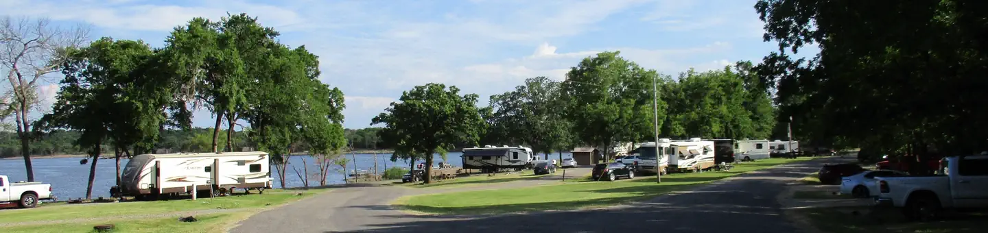
Blue Bill Point is located on the banks of Flat Rock Bay on tranquil Fort Gibson Lake in northeastern Oklahoma. Blue Bill is a peaceful campground popular with family groups and retirees. The gradual sloping shoreline offers easy access to the water for fishing, swimming and mooring boats. This protected shallow cove is an ideal location for kayaks and canoes.Recreation
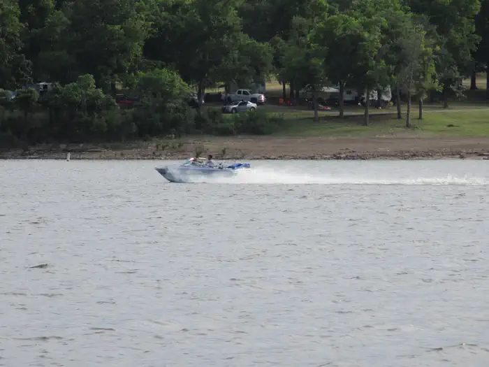
The nearly 20,000-acre lake offers excellent boating and swimming opportunities. Anglers enjoy fishing for black bass, white bass, crappie and several varieties of catfish and panfish. The lake's 225 miles of shoreline and thousands of acres of public hunting lands are abundant with wildlife.Facilities
This campground is open year-round and offers 40 family sites and one group day-use picnic shelter, all with electric hookups. Three additional primitive sites without hookups are available.
Amenities include flush and pit toilets, drinking water, showers, a dump station, playground, concrete cornhole pitch, 2 boat ramps and courtesy dock.
Natural Features
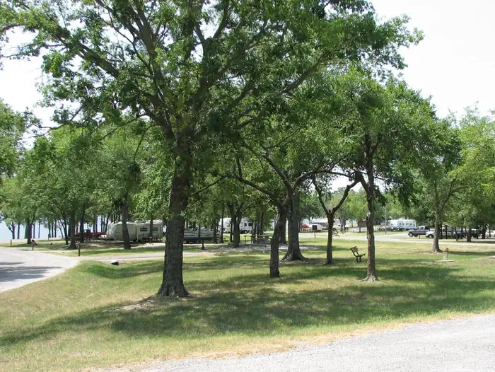
Blue Bill Point is surrounded by a mixed hardwood forest. A small fishing pond is located a short distance outside the campground. Cultivated fields offer an opportunity to view wildlife as they graze or cross these open areas.Nearby Attractions
Historic Fort Gibson, established in 1824, served as an important military post on the western frontier for close to 70 years. Now a National Historical Landmark, the site is open to the public year round.Volunteers reenact the lifestyle of the late 1800s during various events held throughout the year. A reconstructed log stockade, and original barracks, hospital, bakehouse and other structures still stand today.
Charges & Cancellations
Cancellations made 48 hrs or more prior to the start of the reservation will incur the cancellation fee of $10.
Cancellations made 24 hrs prior to the start of the reservation will incur a late cancellation fee ($10 + first nights camping fee)
The facts
- 41 bookable sites
- 1 site for day use only
- 8 accessible sites
- Vehicles up to 50 ft
- Up to 100 people per site
- Loops: BBIL
Site types
- 37 Standard Electric
- 3 Standard Nonelectric
- 1 Group Shelter Electric
Amenities
- Electric hookups
- Water hookups
- Campfires allowed
- Shade
- Pets allowed
Not recorded upstream: sewer hookups, fire pits, picnic tables, grills.
41 campsites at Blue Bill Point
| Site | Loop | Type | Entry | Surface | Max rig | People | |
|---|---|---|---|---|---|---|---|
| 01 | BBIL | Standard Electric | Back In | Paved | 45 ft | 8 | 🐾 |
| 02 | BBIL | Standard Electric | Back In | Paved | 25 ft | 8 | 🐾 |
| 03 | BBIL | Standard Electric | Back In | Paved | 45 ft | 8 | 🐾 |
| 05 | BBIL | Standard Electric | Back In | Paved | 15 ft | 8 | 🐾 |
| 06 | BBIL | Standard Electric | Back In | Paved | 35 ft | 8 | 🐾 |
| 07 | BBIL | Standard Nonelectric | Back In | Paved | 40 ft | 8 | 🐾 |
| 08 | BBIL | Standard Electric | Back In | Paved | 35 ft | 8 | 🐾 |
| 09 | BBIL | Standard Electric | Back In | Paved | 20 ft | 8 | 🐾 |
| 10 | BBIL | Standard Electric | Back In | Paved | 45 ft | 8 | 🐾 |
| 11 | BBIL | Standard Electric | Back In | Paved | 45 ft | 8 | 🐾 |
| 12 | BBIL | Standard Electric | Back In | Paved | 25 ft | 8 | 🐾 |
| 13 | BBIL | Standard Electric | Back In | Paved | 45 ft | 8 | 🐾 |
| 14 | BBIL | Standard Electric | Back In | Paved | 45 ft | 8 | 🐾 |
| 15 | BBIL | Standard Electric | Pull Through | Paved | 45 ft | 8 | 🐾 |
| 16 | BBIL | Standard Electric | Pull Through | Paved | 45 ft | 8 | 🐾 |
| 17 | BBIL | Standard Electric | Back In | Paved | 45 ft | 8 | 🐾 |
| 18 | BBIL | Standard Electric | Pull Through | Paved | 45 ft | 8 | 🐾 |
| 19 | BBIL | Standard Electric | Pull Through | Paved | 45 ft | 8 | 🐾 |
| 20 | BBIL | Standard Electric | Back In | Paved | 45 ft | 8 | 🐾 |
| 21 | BBIL | Standard Electric | Back In | Paved | 45 ft | 8 | 🐾 |
| 22 | BBIL | Standard Nonelectric | Back In | Paved | 30 ft | 8 | 🐾 |
| 23 | BBIL | Standard Nonelectric | Back In | Paved | 25 ft | 8 | 🐾 |
| 26 | BBIL | Standard Electric | — | Paved | 45 ft | 8 | 🐾 |
| 27 | BBIL | Standard Electric | Back In | Paved | 45 ft | 8 | 🐾 |
| 28 | BBIL | Standard Electric | — | Paved | 45 ft | 8 | 🐾 |
| 29 | BBIL | Standard Electric | Back In | Paved | 45 ft | 8 | 🐾 |
| 30 | BBIL | Standard Electric | Back In | Paved | 25 ft | 8 | 🐾 |
| 31 | BBIL | Standard Electric | Back In | Paved | 40 ft | 8 | 🐾 |
| 32 | BBIL | Standard Electric | Back In | Paved | 45 ft | 8 | 🐾 |
| 33 | BBIL | Standard Electric | Back In | Paved | 45 ft | 8 | 🐾 |
| 34 | BBIL | Standard Electric | Back In | Paved | 45 ft | 8 | 🐾 |
| 35 | BBIL | Standard Electric | Back In | Paved | 45 ft | 8 | 🐾 |
| 36 | BBIL | Standard Electric | Back In | Paved | 50 ft | 8 | ♿ 🐾 |
| 37 | BBIL | Standard Electric | Back In | Paved | 50 ft | 8 | ♿ 🐾 |
| 38 | BBIL | Standard Electric | Back In | Paved | 50 ft | 8 | ♿ 🐾 |
| 39 | BBIL | Standard Electric | Back In | Paved | 50 ft | 8 | ♿ 🐾 |
| 40 | BBIL | Standard Electric | Back In | Paved | 50 ft | 8 | ♿ 🐾 |
| 41 | BBIL | Standard Electric | Back In | Paved | 50 ft | 8 | ♿ 🐾 |
| 42 | BBIL | Standard Electric | Back In | Paved | 50 ft | 8 | ♿ 🐾 |
| 43 | BBIL | Standard Electric | Back In | Paved | 50 ft | 8 | ♿ 🐾 |
| BBS | BBIL | Group Shelter Electric | Back In | — | 15 ft | 100 | 🐾 |
Getting there
Address for GPS: Blue Bill Point Campground, 67260 S. 307 Rd., Wagoner, Oklahoma 74467.
From the intersection of US Highway 69 and State Highway 51 in Wagoner, Oklahoma, travel north on Highway 69 for 5.5 miles. Turn right on East 680 Road and travel east for 1 mile. Follow curve to the left and travel south for another mile. Follow curve to the right and travel east for an additional mile to park entrance.
GPS Coordinates: 36.043153, -95.336889
36.04315, -95.33689 · 36°2'35.4"N 95°20'12.8"W
Typical weather
Typically 93°F in Aug, down to 49°F in Jan.
| Jan | Feb | Mar | Apr | May | Jun | Jul | Aug | Sep | Oct | Nov | Dec | |
|---|---|---|---|---|---|---|---|---|---|---|---|---|
| High °F | 49 | 55 | 64 | 73 | 80 | 87 | 92 | 93 | 84 | 73 | 62 | 52 |
| Low °F | 29 | 33 | 41 | 50 | 60 | 68 | 73 | 71 | 63 | 51 | 40 | 32 |
| Precip in | — | — | — | — | — | — | — | — | — | — | — | — |
1991–2020 averages from the nearest NOAA station, 5.6 mi away — not measured at the facility itself, and elevation can make a real difference over that distance.
Map
More photos
Member photos
Common questions about Blue Bill Point
- Can you reserve a site at Blue Bill Point?
- Yes, Blue Bill Point is reservable through Recreation.gov.
- How many campsites does Blue Bill Point have?
- 41 sites.
- What is the maximum RV length at Blue Bill Point?
- 50 ft. That is the longest vehicle the sites here are recorded as taking; individual sites may be shorter.
- Are pets allowed at Blue Bill Point?
- Yes, pets are allowed at Blue Bill Point.
- Does Blue Bill Point have hookups?
- Electric, Water.
- Are campfires allowed at Blue Bill Point?
- Campfires are allowed at Blue Bill Point. Check for a current fire restriction before you go.
Camping near Blue Bill Point
- Flat Rock Creek 0.6 mi · Campground · we watch it
- Rocky Point (FT Gibson) 1.2 mi · Campground · we watch it
- Taylor Ferry 8.1 mi · Campground · we watch it
- Afton Landing 10.6 mi · Campground · we watch it
- Wahoo Bay 11.2 mi · Campground · we watch it
- Tullahasse Loop 12.3 mi · Campground · we watch it
- Dam Site (Fort Gibson Lake) 13.4 mi · Campground · we watch it
- Pettit Bay 29.6 mi · Campground · we watch it
- Cookson Bend 31.4 mi · Campground · we watch it
- Elk Creek Landing 31.6 mi · Campground · we watch it
- Blue Creek 31.6 mi · Campground · we watch it
- Chicken Creek 32.6 mi · Campground · we watch it
Contact
- Phone 918-476-6638 OR 918-682-4314
- Book Recreation.gov
Recreation.gov last updated this record on 2026-02-25.
Facility information and photographs from Recreation.gov (RIDB). SpotOpened is not affiliated with Recreation.gov or any federal agency.
Comments