Mosier Gulch
Facility · Wyoming ·
Managed by the Bureau of Land Management
Buffalo Field Office (Bureau of Land Management WY) · Open Access
- 5,763 ft
- Elevation
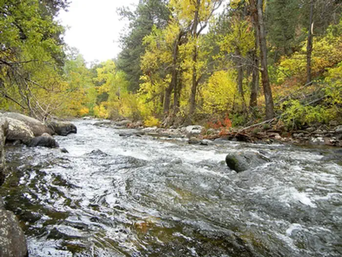
Mosier Gulch Picnic Area is managed by the Bureau of Land Management and the City of Buffalo and is adjacent to the Bighorn National Forest, managed by the USDA Forest Service. This ponderosa pine-forested area lies at the foothills of the Bighorn Mountains.
The recreation area encompasses almost 900 acres of ponderosa pine-forested lands ranging from 5,500 feet to 6,800 feet, and is a popular hiking area. A developed roadside picnic area complete with multiple parking areas, picnic tables, pedestal fire grates, and a vault toilet are available.
In addition, the picnic area is along the Clear Creek Trail which leads back to the city of Buffalo to the east or into the Bighorn Mountains to the west.
Other opportunities at Mosier Gulch include trout fishing along Clear Creek, hunting and wildlife viewing with opportunities to see mule deer, antelope, eagles, and occasionally black bear and elk.
Mosier Gulch is a day use only facility. Camping, open fires, and target shooting are prohibited. There is a hand-pump well available during the summer months. Please help us keep the area clean and pack your trash out as garbage collection is not provided.
The recreation area encompasses almost 900 acres of ponderosa pine-forested lands ranging from 5,500 feet to 6,800 feet, and is a popular hiking area. A developed roadside picnic area complete with multiple parking areas, picnic tables, pedestal fire grates, and a vault toilet are available.
In addition, the picnic area is along the Clear Creek Trail which leads back to the city of Buffalo to the east or into the Bighorn Mountains to the west.
Other opportunities at Mosier Gulch include trout fishing along Clear Creek, hunting and wildlife viewing with opportunities to see mule deer, antelope, eagles, and occasionally black bear and elk.
Mosier Gulch is a day use only facility. Camping, open fires, and target shooting are prohibited. There is a hand-pump well available during the summer months. Please help us keep the area clean and pack your trash out as garbage collection is not provided.
Getting there
From Buffalo, go about 5.5 miles west on Cloud Peak Scenic Byway (US 16). The road and picnic area are on the left.
44.33173, -106.81395 · 44°19'54.2"N 106°48'50.2"W
Typical weather
| Jan | Feb | Mar | Apr | May | Jun | Jul | Aug | Sep | Oct | Nov | Dec | |
|---|---|---|---|---|---|---|---|---|---|---|---|---|
| High °F | — | — | — | — | — | — | — | — | — | — | — | — |
| Low °F | — | — | — | — | — | — | — | — | — | — | — | — |
| Precip in | 0.3 | 0.6 | 0.9 | 1.9 | 3.8 | 2.2 | 1.9 | 0.9 | 1.5 | 1.5 | 0.6 | 0.5 |
1991–2020 averages from the nearest NOAA station, 1.3 mi away — not measured at the facility itself, and elevation can make a real difference over that distance.
Map
Member photos
Common questions about Mosier Gulch
- Can you reserve a site at Mosier Gulch?
- No. Mosier Gulch is not reservable through Recreation.gov, so sites are first-come, first-served or booked elsewhere.
Camping near Mosier Gulch
- Middle Fork 7 mi · Campground · we watch it
- Hettinger Group Area 7.2 mi · Campground · we watch it
- Tie Hack 7.2 mi · Campground · we watch it
- South Fork (Wyoming) 7.4 mi · Campground · we watch it
- Hunter Campground 7.9 mi · Campground · we watch it
- Circle Park Campground 9.4 mi · Campground · we watch it
- Pole Creek Cabin 11.4 mi · Campground · we watch it
- Muddy Guard Cabin 12.9 mi · Campground · we watch it
- Sheep Mountain Fire Lookout 13.6 mi · Campground · we watch it
- Lost Cabin Campground 14.4 mi · Campground · we watch it
- Dry Creek Petrified Tree Environmental Education Area 14 mi · Facility
- Poison Creek Trail 16.5 mi · Facility
Contact
- Phone (307) 684-1100
- Email buffalo_wymail@blm.gov
- Info Recreation.gov
Recreation.gov last updated this record on 2026-02-25.
Facility information and photographs from Recreation.gov (RIDB). SpotOpened is not affiliated with Recreation.gov or any federal agency.
Comments