Poison Creek Trail
Facility · Wyoming ·
Managed by the Bureau of Land Management
Buffalo Field Office (Bureau of Land Management WY) · Open Access
- 7,571 ft
- Elevation
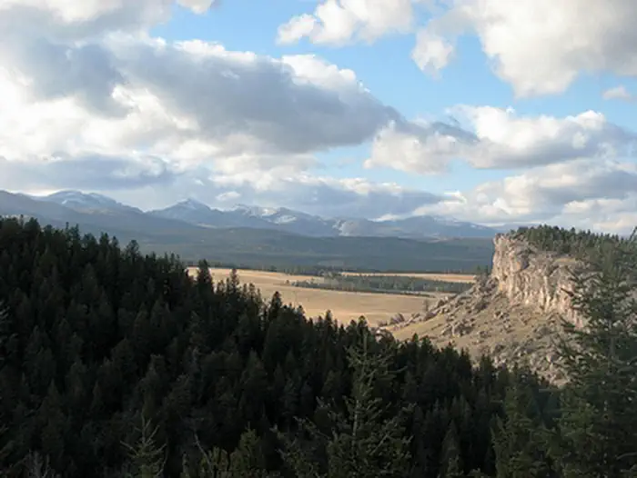
The two mile long Poison Creek Trail ambles through mountain meadows before descending steeply to Poison Creek. The first part of the trail provides spectacular views of the Bighorn Mountains and the valley below. Hikers who make it to the end are rewarded with a secluded spot along the Poison Creek. Backcountry camping is allowed in the recreation area.
Getting there
From Buffalo, take Highway 16 West to Hazelton Road. Turn south onto Hazelton Road and travel approximately 0.7 mile, then turn left onto FS Road 466(sign for Johnson County Youth Camp). After about 3 miles, turn left onto Billy Creek Road. The trailhead and parking area will be about 3.5 miles on your right.
44.09365, -106.84511 · 44°5'37.1"N 106°50'42.4"W
Typical weather
Typically 86°F in Jul, down to 39°F in Jan.
| Jan | Feb | Mar | Apr | May | Jun | Jul | Aug | Sep | Oct | Nov | Dec | |
|---|---|---|---|---|---|---|---|---|---|---|---|---|
| High °F | 39 | 40 | 49 | 55 | 64 | 76 | 86 | 84 | 74 | 60 | 48 | 39 |
| Low °F | 12 | 15 | 22 | 30 | 39 | 48 | 55 | 53 | 43 | 31 | 21 | 12 |
| Precip in | 0.3 | 0.4 | 0.6 | 1.5 | 2.8 | 2.1 | 1.6 | 0.8 | 1.3 | 1.1 | 0.5 | 0.3 |
1991–2020 averages from the nearest NOAA station, 6 mi away — not measured at the facility itself, and elevation can make a real difference over that distance.
Map
Member photos
Common questions about Poison Creek Trail
- Can you reserve a site at Poison Creek Trail?
- No. Poison Creek Trail is not reservable through Recreation.gov, so sites are first-come, first-served or booked elsewhere.
Camping near Poison Creek Trail
- Muddy Guard Cabin 5.6 mi · Campground · we watch it
- Lost Cabin Campground 6.6 mi · Campground · we watch it
- Doyle Creek Campground 7.2 mi · Campground · we watch it
- Pole Creek Cabin 8.4 mi · Campground · we watch it
- Sheep Mountain Fire Lookout 10.3 mi · Campground · we watch it
- South Fork (Wyoming) 13.8 mi · Campground · we watch it
- Tie Hack 14 mi · Campground · we watch it
- Circle Park Campground 14.9 mi · Campground · we watch it
- Hettinger Group Area 15 mi · Campground · we watch it
- Middle Fork 15.3 mi · Campground · we watch it
- Powder River Interpretive Site 12.3 mi · Facility
- Mosier Gulch 16.5 mi · Facility
Contact
- Phone 307-684-1100
- Email buffalo_wymail@blm.gov
- Info Recreation.gov
Recreation.gov last updated this record on 2026-02-25.
Facility information and photographs from Recreation.gov (RIDB). SpotOpened is not affiliated with Recreation.gov or any federal agency.
Comments