Dry Creek Petrified Tree Environmental Education Area
Facility · Wyoming ·
Managed by the Bureau of Land Management
Buffalo Field Office (Bureau of Land Management WY) · Open Access
- 4,597 ft
- Elevation
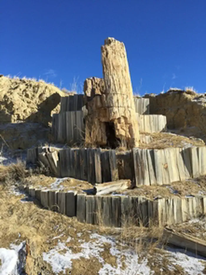
The Dry Creek Petrified Tree Environmental Education Area is located about 13 miles east of Buffalo, Wyoming. The site offers visitors an opportunity to discover the history of the northeastern Wyoming landscape. About 60 million years ago these red sage hills and sagebrush country were a jungle-like swamp with towering Metasequoia trees. Many of these trees still exist as petrified wood.
A 0.8 mile interpretive loop trail winds its way through portions of remnant petrified trees. Vault toilets and a shelter with picnic tables are available. Dispersed camping is allowed in the recreation area, outside of the fenced-in trail and picnic area.
Getting there
To access the area from Interstate 90, take the Red Hills/Tipperary Road (Exit 65). Cross under the interstate and head northeast on Tipperary Road for 6 miles. Turn left onto the Petrified Tree access road, directly across the road from a ranch house. This two-track will cross a cattle guard and continue about 0.6 mile to the parking area. The road to this area is a graveled all-weather road, but snow drifts are common in the winter months.
44.35237, -106.53286 · 44°21'8.5"N 106°31'58.3"W
Typical weather
Typically 83°F in Jul, down to 36°F in Jan.
| Jan | Feb | Mar | Apr | May | Jun | Jul | Aug | Sep | Oct | Nov | Dec | |
|---|---|---|---|---|---|---|---|---|---|---|---|---|
| High °F | 36 | 37 | 47 | 53 | 62 | 73 | 83 | 82 | 72 | 57 | 45 | 36 |
| Low °F | 11 | 12 | 20 | 28 | 37 | 46 | 53 | 51 | 42 | 30 | 19 | 11 |
| Precip in | 0.4 | 0.5 | 0.7 | 1.5 | 2.8 | 2.2 | 1.4 | 0.8 | 1.3 | 1.3 | 0.5 | 0.4 |
1991–2020 averages from the nearest NOAA station, 8.2 mi away — not measured at the facility itself, and elevation can make a real difference over that distance.
Map
More photos

Member photos
Common questions about Dry Creek Petrified Tree Environmental Education Area
- Can you reserve a site at Dry Creek Petrified Tree Environmental Education Area?
- No. Dry Creek Petrified Tree Environmental Education Area is not reservable through Recreation.gov, so sites are first-come, first-served or booked elsewhere.
Camping near Dry Creek Petrified Tree Environmental Education Area
- Tie Hack 20.8 mi · Campground · we watch it
- Middle Fork 20.9 mi · Campground · we watch it
- South Fork (Wyoming) 21 mi · Campground · we watch it
- Hettinger Group Area 21 mi · Campground · we watch it
- Hunter Campground 21.8 mi · Campground · we watch it
- Pole Creek Cabin 23 mi · Campground · we watch it
- Muddy Guard Cabin 23 mi · Campground · we watch it
- Circle Park Campground 23.1 mi · Campground · we watch it
- Lost Cabin Campground 25.1 mi · Campground · we watch it
- Sheep Mountain Fire Lookout 25.9 mi · Campground · we watch it
- Mosier Gulch 14 mi · Facility
- Poison Creek Trail 23.6 mi · Facility
Contact
- Phone 307-684-1100
- Email buffalo_wymail@blm.gov
- Info Recreation.gov
Recreation.gov last updated this record on 2026-02-25.
Facility information and photographs from Recreation.gov (RIDB). SpotOpened is not affiliated with Recreation.gov or any federal agency.
Comments