Keowee Park Shelter
Campground · North Carolina · 1 bookable site ·
Managed by the US Army Corps of Engineers
W. Kerr Scott Reservoir (Other Designation) · Open Access
- 1
- Bookable site
- up to 40
- People per site
- 1,082 ft
- Elevation
Overview
Keowee Park Shelter is located within Keowee Park at W. Kerr Scott Dam and Reservoir in northwestern North Carolina.Recreation
The 1,475-acre reservoir offers excellent boating, canoeing, kayaking and swimming opportunities. Anglers will find channel catfish, large and smallmouth bass, bluegill, threadfin shad, spotted bass, striped bass, and hybrid striped bass. Roughly 30 miles of multi-purpose trails surround the lake, including the Warrior Creek trails which are easily accessible from the shelter. All of the trails, including Warrior Creek, are now recognized as some of the best mountain biking trails in the country attracting riders from all corners of the world.Facilities
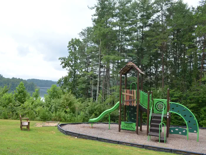
The shelter offers six, 8-foot picnic tables. Water and electricity are not available at the shelter, please plan accordingly. Along with scenic views, you can enjoy other park amenities which include a boat ramp, playground, horseshoe pit, grill, vault toilets, and three fishing piers (one is ADA accessible).Natural Features
The gentle Yadkin River flows through its scenic namesake valley in the foothills of the eastern Blue Ridge Mountains. Forests of mixed hardwoods, including sycamore, poplar, oak and hickory, cover the region. Wildlife is abundant in the valley. White-tailed deer, black bear, eastern cottontails and more can be found among the hills. Birds in the area include wild turkey, woodpeckers, Carolina chickadees, red-eyed vireo, ovenbirds, mallards and wood ducks.Contact Info
For facility specific information, please call (336) 921-3390.The facts
- 1 bookable site
- 1 site for day use only
- Up to 40 people per site
- Loops: KEOWEE PARK SHELTER
Site types
- 1 Group Shelter Nonelectric
Amenities
- Grills
- Shade
- Pets allowed
Not recorded upstream: electric hookups, water hookups, sewer hookups, campfires allowed, fire pits, picnic tables.
1 campsite at Keowee Park Shelter
Check-in 8:00 AM · Check-out 8:00 PM
| Site | Loop | Type | Entry | Surface | Water | Max rig | People | |
|---|---|---|---|---|---|---|---|---|
| Keowee Park | KEOWEE PARK SHELTER | Group Shelter Nonelectric | — | Paved | Lakefront | — | 40 | 🐾 |
Getting there
From Charlotte, North Carolina, take I-77 North (approximately 60 miles) before merging onto Highway 421 North towards Wilkesboro/Boone. Continue to Exit 286B (approximately 20 miles), turn left onto Highway 268 and continue for approximately 7.5 miles. Turn the first right after the bridge. (You will see a sign for Warrior Creek Campground.) Continue on this access road and the shelter will be straight past the gatehouse.
From Winston-Salem, North Carolina, take Highway 421 North (approximately 55 miles) to Exit 286B, turn left onto Highway 268 and continue for approximately 7.5 miles. Turn the first right after the bridge. (You will see a sign for Warrior Creek Campground.) Continue on this access road and the shelter will be straight past the gatehouse.
From Wilkesboro, North Carolina, head west on Main Street/Hwy 268/Hwy 18 (approximately 8.5 miles) and turn right on the Warrior Creek Campground access road (directly across from Edmiston Road). Continue on this access road and the shelter will be straight past the gatehouse.
36.10417, -81.28333 · 36°6'15.0"N 81°16'60.0"W
Typical weather
Typically 88°F in Jul, down to 49°F in Jan.
| Jan | Feb | Mar | Apr | May | Jun | Jul | Aug | Sep | Oct | Nov | Dec | |
|---|---|---|---|---|---|---|---|---|---|---|---|---|
| High °F | 49 | 53 | 61 | 71 | 78 | 85 | 88 | 86 | 81 | 72 | 61 | 52 |
| Low °F | 27 | 29 | 36 | 44 | 54 | 62 | 66 | 65 | 59 | 46 | 36 | 30 |
| Precip in | 4.5 | 3.4 | 4.5 | 4.8 | 4.7 | 4.3 | 4.3 | 5.6 | 4.4 | 3.9 | 3.5 | 4.6 |
1991–2020 averages from the nearest NOAA station, 3.6 mi away — not measured at the facility itself, and elevation can make a real difference over that distance.
Map
Member photos
Common questions about Keowee Park Shelter
- Can you reserve a site at Keowee Park Shelter?
- Yes, Keowee Park Shelter is reservable through Recreation.gov.
- How many campsites does Keowee Park Shelter have?
- 1 site.
- Are pets allowed at Keowee Park Shelter?
- Yes, pets are allowed at Keowee Park Shelter.
Camping near Keowee Park Shelter
- Warrior Creek 0.3 mi · Campground · we watch it
- Boomer Park Shelter 0.7 mi · Campground · we watch it
- Fort Hamby Park 1.9 mi · Campground · we watch it
- Bandits Roost 2.2 mi · Campground · we watch it
- Berry Mountain Park Shelter 2.7 mi · Campground · we watch it
- Dam Site Shelter 3.5 mi · Campground · we watch it
- W. Kerr Scott Visitor Assistance Center Conference Room 3.6 mi · Campground · we watch it
- Fish Dam Creek Park 3.9 mi · Campground · we watch it
- Basin Cove Backcountry Camping 20.9 mi · Campground · we watch it
- W. Kerr Scott Dam & Reservoir Visitor Center 3.6 mi · Visitor Center
- Green Park Inn 21.2 mi · Facility
- Moses Cone Manor House and Visitor Center (Milepost 294) 23.1 mi · Facility
Contact
- Phone 336-921-3390
- Book Recreation.gov
Recreation.gov last updated this record on 2026-02-25.
Facility information and photographs from Recreation.gov (RIDB). SpotOpened is not affiliated with Recreation.gov or any federal agency.
Comments