Mingo Wilderness
Facility · Missouri ·
Managed by the Fish and Wildlife Service
Mingo National Wildlife Refuge (NWR) · Restricted Access
- 460 ft
- Elevation
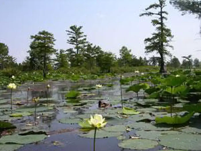
The Mingo Wilderness now contains a total of 7,730 acres and is managed by the Fish & Wildlife Service. All of the Wilderness is in the state of Missouri. In 1976 the Mingo Wilderness became part of the now over 110 million acre National Wilderness Preservation System.
Eighteen thousand years ago, the Mississippi River flowed through this area on its way to the Gulf of Mexico. Because of natural events, the river shifted east forming a biologically rich swampland comprised of bottomland hardwoods intermixed with cypress and tupelo. The former channel basin attracted Native Americans who utilized the bountiful natural resources. By the late 1800’s, settlers and loggers started draining the swamp while removing large tracts of old-growth forest. In 1944, Congress authorized the purchase of the remnant forest lands to create the 21,592 acre Mingo National Wildlife Refuge. Today, Mingo Wilderness is a large fragment of this refuge. The wilderness provides critical food and shelter for bald eagles and migratory waterfowl along the Mississippi Flyway. Giant cypress dominates the wilderness swamp offering nesting platforms for eagles and other birds. Otters and beaver, turkey and amphibians are frequent sightings for visitors. Predator-proof nesting boxes, used commonly by the evasive wood ducks, dot the refuge.
The western one-third of the refuge offers a wilderness setting with diverse habitat and abundant wildlife, an area highlighted with gentle rolling hills of the Ozark Plateau nestled beside Monopoly Marsh with intersecting streams and rich swamplands. Meandering underneath a canvas of cypress and mixed hardwoods, the Stanley Creek and Mingo River flows gently out of the Mingo Wilderness into the remainder of the Refuge--offering many miles of ditches for easy canoe access.
Getting there
Mingo Wilderness nestles between the gentle rolling hills of the Ozark Plateau and the boothill region of southeast Missouri. Located one mile north of Puxico, Missouri, the Refuge Office is a good place to find information on the wilderness, visitor rules, wildlife viewing opportunities, and other information.
The Visitor Center is open Monday through Saturday 8:30 a.m. to 4:00 p.m from March through November. During December, January and February the Visitor Center is open Monday through Friday from 8:30 a.m. to 4 p.m. The Visitor Center is closed on most Federal holiday weekends.
36.96924, -90.15011 · 36°58'9.3"N 90°9'0.4"W
Typical weather
Typically 88°F in Jul, down to 42°F in Jan.
| Jan | Feb | Mar | Apr | May | Jun | Jul | Aug | Sep | Oct | Nov | Dec | |
|---|---|---|---|---|---|---|---|---|---|---|---|---|
| High °F | 42 | 47 | 56 | 68 | 76 | 85 | 88 | 87 | 81 | 69 | 56 | 45 |
| Low °F | 24 | 28 | 37 | 46 | 57 | 65 | 69 | 67 | 60 | 47 | 36 | 28 |
| Precip in | 3.8 | 3.5 | 5.0 | 5.4 | 5.6 | 4.0 | 4.4 | 3.5 | 3.6 | 3.8 | 4.7 | 4.2 |
1991–2020 averages from the nearest NOAA station, 8 mi away — not measured at the facility itself, and elevation can make a real difference over that distance.
Map
Member photos
Common questions about Mingo Wilderness
- Can you reserve a site at Mingo Wilderness?
- No. Mingo Wilderness is not reservable through Recreation.gov, so sites are first-come, first-served or booked elsewhere.
Camping near Mingo Wilderness
- Peoples Creek 7.1 mi · Campground · we watch it
- Eagle Point Recreation Area 7.4 mi · Campground · we watch it
- Spillway Recreation Area 7.9 mi · Campground · we watch it
- Redman Creek Recreation Area 7.9 mi · Campground · we watch it
- Snow Creek Campground 11.5 mi · Campground · we watch it
- Greenville Recreation Area 19.1 mi · Campground · we watch it
- Markham Springs 24.9 mi · Campground · we watch it
- Fuchs House 25 mi · Campground · we watch it
- Pinewoods Lake Rec Area 35.2 mi · Campground · we watch it
- Hendrickson Boat Launch 18.5 mi · Facility
- Markham Springs Recreation Area 25.1 mi · Campground
- Pinewoods Lake Recreation Area 34.6 mi · Campground
Contact
- Phone 573-222-3589
- Email Mingo@fws.gov
- Info Recreation.gov
Recreation.gov last updated this record on 2026-02-25.
Facility information and photographs from Recreation.gov (RIDB). SpotOpened is not affiliated with Recreation.gov or any federal agency.
Comments