Beaver Creek (Mo)
Campground · Missouri · 34 bookable sites ·
Managed by the US Army Corps of Engineers
Bull Shoals Recreation Area (Recreation Area) · Open Access
- 34
- Bookable sites
- 42 ft
- Max rig length
- up to 60
- People per site
- 707 ft
- Elevation
Overview
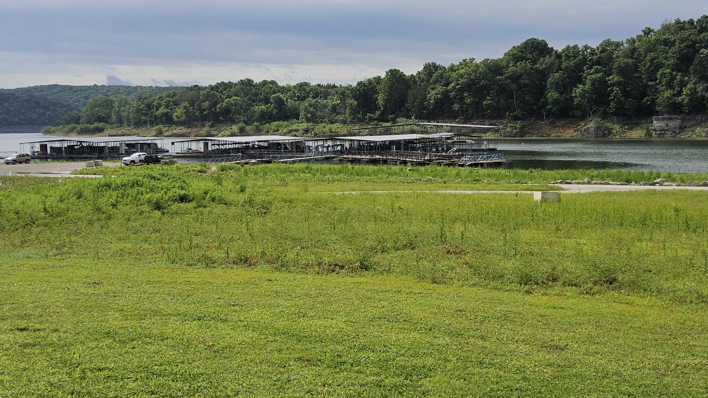
Escape from the hustle and bustle of city-life at Beaver Creek, a small, quiet campground tucked between a forested area and the lower shores of Bull Shoals Lake. The lake, in the beautiful Ozark Mountains, attracts visitors year-round as each season unfolds a new panorama.Recreation
Hiking, birding, all types of water sports, and in-season hunting are featured attractions.Spring and fall are the best seasons for fishing, but spotted bass, crappie and similar fish can be sought throughout the year.
Facilities
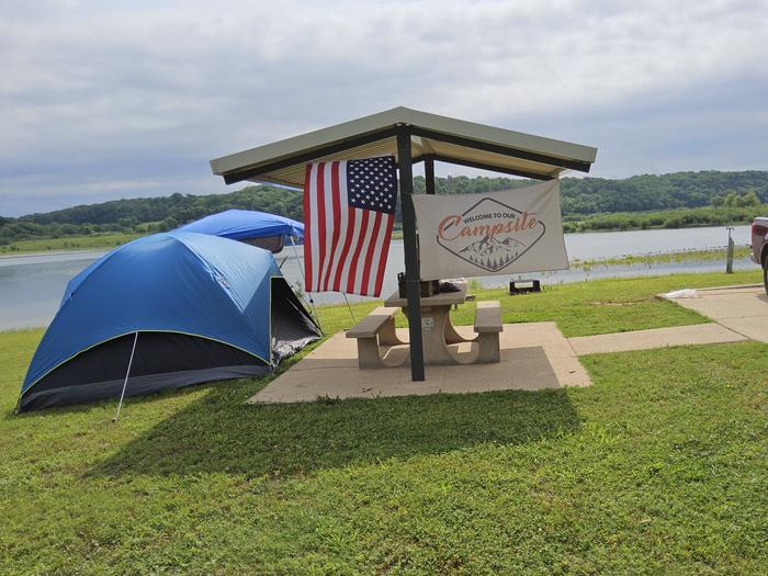
Beaver Creek hosts 33 campsites with electrical hookups and hot showers. A group shelter, playground and marina are also on-site.Natural Features
The campground is in south-central Missouri along the Beaver Creek arm of Bull Shoals Lake. Sturdy, green hardwoods and cedar glades encompass the rocky bluffs and unique rock formations of the mountains.Nearby Attractions
Visit the Jones Point State Wildlife Management Area for promising wildlife spotting and birding.The lively tourist town of Branson is just 30 minutes away. Here, visitors can shop, dine and find live music.
Charges & Cancellations
Cancellations up to 2 days before a reservation start date incur a $10.00 cancellation fee.
The facts
- 34 bookable sites
- 1 site for day use only
- Vehicles up to 42 ft
- Up to 60 people per site
- Loops: BEAVER CREEK
Site types
- 33 Standard Electric
- 1 Group Shelter Electric
Amenities
- Electric hookups
- Water hookups
- Campfires allowed
- Fire pits
- Picnic tables
- Shade
- Pets allowed
Not recorded upstream: sewer hookups, grills.
34 campsites at Beaver Creek (Mo)
| Site | Loop | Type | Entry | Surface | Max rig | People | |
|---|---|---|---|---|---|---|---|
| 02 | BEAVER CREEK | Standard Electric | Back In | Paved | 30 ft | 10 | 🐾 |
| 03 | BEAVER CREEK | Standard Electric | Back In | Paved | 30 ft | 10 | 🐾 |
| 04 | BEAVER CREEK | Standard Electric | Back In | Paved | 30 ft | 10 | 🐾 |
| 05 | BEAVER CREEK | Standard Electric | Back In | Paved | 26 ft | 10 | 🐾 |
| 06 | BEAVER CREEK | Standard Electric | Back In | Paved | 30 ft | 10 | 🐾 |
| 07 | BEAVER CREEK | Standard Electric | Back In | Paved | 36 ft | 10 | 🐾 |
| 08 | BEAVER CREEK | Standard Electric | Back In | Paved | 42 ft | 10 | 🐾 |
| 09 | BEAVER CREEK | Standard Electric | Back In | Paved | 42 ft | 10 | 🐾 |
| 10 | BEAVER CREEK | Standard Electric | Back In | Paved | 36 ft | 10 | 🐾 |
| 11 | BEAVER CREEK | Standard Electric | Back In | Paved | 36 ft | 10 | 🐾 |
| 12 | BEAVER CREEK | Standard Electric | Back In | Paved | 30 ft | 10 | 🐾 |
| 13 | BEAVER CREEK | Standard Electric | Back In | Paved | 30 ft | 10 | 🐾 |
| 14 | BEAVER CREEK | Standard Electric | Back In | Paved | 36 ft | 10 | 🐾 |
| 15 | BEAVER CREEK | Standard Electric | Back In | Paved | 36 ft | 10 | 🐾 |
| 16 | BEAVER CREEK | Standard Electric | Back In | Paved | 36 ft | 10 | 🐾 |
| 17 | BEAVER CREEK | Standard Electric | Back In | Paved | 36 ft | 10 | 🐾 |
| 18 | BEAVER CREEK | Standard Electric | Back In | Paved | 36 ft | 10 | 🐾 |
| 19 | BEAVER CREEK | Standard Electric | Back In | Paved | 36 ft | 10 | 🐾 |
| 20 | BEAVER CREEK | Standard Electric | Back In | Paved | 42 ft | 10 | 🐾 |
| 21 | BEAVER CREEK | Standard Electric | Back In | Paved | 42 ft | 10 | 🐾 |
| 25 | BEAVER CREEK | Standard Electric | Back In | Paved | 42 ft | 10 | 🐾 |
| 26 | BEAVER CREEK | Standard Electric | Pull Through | Paved | 40 ft | 10 | 🐾 |
| 27 | BEAVER CREEK | Standard Electric | Back In | Paved | 40 ft | 10 | 🐾 |
| 28 | BEAVER CREEK | Standard Electric | Back In | Paved | 40 ft | 10 | 🐾 |
| 29 | BEAVER CREEK | Standard Electric | Pull Through | Paved | 40 ft | 10 | 🐾 |
| 30 | BEAVER CREEK | Standard Electric | Back In | Paved | 36 ft | 10 | 🐾 |
| 31 | BEAVER CREEK | Standard Electric | Back In | Paved | 36 ft | 10 | 🐾 |
| 32 | BEAVER CREEK | Standard Electric | Back In | Paved | 27 ft | 10 | 🐾 |
| 33 | BEAVER CREEK | Standard Electric | Back In | Paved | 30 ft | 10 | 🐾 |
| 34 | BEAVER CREEK | Standard Electric | Back In | Paved | 30 ft | 10 | 🐾 |
| 35 | BEAVER CREEK | Standard Electric | Back In | Paved | 36 ft | 10 | 🐾 |
| 36 | BEAVER CREEK | Standard Electric | Back In | Paved | 30 ft | 10 | 🐾 |
| 37 | BEAVER CREEK | Standard Electric | Back In | Paved | 30 ft | 10 | 🐾 |
| GS1 | BEAVER CREEK | Group Shelter Electric | — | Paved | — | 60 | 🐾 |
Getting there
From Mountain Home, AR, travel north on State Route 5 for 24 miles to US 160. Follow 160 west for 42 miles to Kissee Mills, MO to junction of State Route O; go left on State Route O. Follow signs to the park.
36.63972, -93.04583 · 36°38'23.0"N 93°2'45.0"W
Typical weather
Typically 92°F in Jul, down to 48°F in Jan.
| Jan | Feb | Mar | Apr | May | Jun | Jul | Aug | Sep | Oct | Nov | Dec | |
|---|---|---|---|---|---|---|---|---|---|---|---|---|
| High °F | 48 | 53 | 62 | 72 | 79 | 88 | 92 | 91 | 84 | 73 | 61 | 50 |
| Low °F | 24 | 28 | 35 | 44 | 54 | 63 | 67 | 65 | 58 | 46 | 35 | 28 |
| Precip in | 2.7 | 2.5 | 4.2 | 4.8 | 5.3 | 4.2 | 4.3 | 3.1 | 4.1 | 3.7 | 3.9 | 2.8 |
1991–2020 averages from the nearest NOAA station, 4.2 mi away — not measured at the facility itself, and elevation can make a real difference over that distance.
Map
More photos

Member photos
Common questions about Beaver Creek (Mo)
- Can you reserve a site at Beaver Creek (Mo)?
- Yes, Beaver Creek (Mo) is reservable through Recreation.gov.
- How many campsites does Beaver Creek (Mo) have?
- 34 sites.
- What is the maximum RV length at Beaver Creek (Mo)?
- 42 ft. That is the longest vehicle the sites here are recorded as taking; individual sites may be shorter.
- Are pets allowed at Beaver Creek (Mo)?
- Yes, pets are allowed at Beaver Creek (Mo).
- Does Beaver Creek (Mo) have hookups?
- Electric, Water.
- Are campfires allowed at Beaver Creek (Mo)?
- Campfires are allowed at Beaver Creek (Mo). Check for a current fire restriction before you go.
Camping near Beaver Creek (Mo)
- River Run Park 4.2 mi · Campground · we watch it
- Tucker Hollow Park 11.5 mi · Campground · we watch it
- Lead Hill 13.3 mi · Campground · we watch it
- Moonshine Beach Rec. Area 14.8 mi · Campground · we watch it
- Old Highway 86 16.2 mi · Campground · we watch it
- Indian Point 16.7 mi · Campground · we watch it
- Buck Creek (Mo) 17.1 mi · Campground · we watch it
- Cricket Creek 17.8 mi · Campground · we watch it
- Cobb Ridge 17.9 mi · Campground · we watch it
- Highway 125 Park Bull Shoals 18.4 mi · Campground · we watch it
- Wolf Junction (GTT Stop 7) 15 mi · Campground
- Bar-K Wrangler Camp 15.4 mi · Campground
Contact
- Phone 417-546-3708
- Book Recreation.gov
Recreation.gov last updated this record on 2026-05-04.
Facility information and photographs from Recreation.gov (RIDB). SpotOpened is not affiliated with Recreation.gov or any federal agency.
Comments