Halfway Flat Campground
Campground · Washington · 8 bookable sites ·
Managed by the USDA Forest Service
Mather Memorial Parkway Memorial Area (Administrative) (Memorial Area (Administrative)) · Restricted Access
- 8
- Bookable sites
- 150 ft
- Max rig length
- up to 8
- People per site
- 2
- Accessible sites
- 2,523 ft
- Elevation
Overview
Halfway Flat Campground is located about 30 miles west of Naches, Washington on the east side of the Cascades mountain range.Recreation
The campground setting provides ready access to the Naches River, where fishing is popular. Hiking and horseback riding trails extend into the William O. Douglas and Norse Peak Wilderness areas, and off-road vehicle and snowmobile access draws visitors to the Little Naches drainage.
Halfway Flat Campground is conveniently located 30 minutes below the summit of Chinook Pass and Mt. Rainer National Park. A trip along the scenic Mather Parkway is a fantastic outing.
The Naches River, adjacent to the campground offers a scenic backdrop for anglers. Its cold, clear waters sustain populations of rainbow and brown trout. Whitewater enthusiasts may enjoy a paddle on the river or one of the many other tributaries.
Facilities
The campground has eight campsites, with five campsites available for advanced reservation between Memorial Day through Labor Day weekend. After, mid-September all sites are available on a first-come, first-served basis. Vault toilets and potable water are available.Natural Features
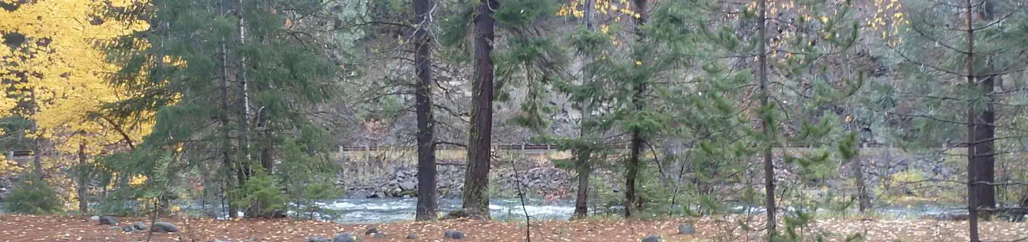
The Halfway Flat Campground is nestled in an old-growth forest of Douglas fir, western hemlock, and cedar with grassy areas, ferns and mosses covering the forest floor. With the William O. Douglas and Norse Peak Wilderness areas nearby, the location is home to abundant wildlife, including deer, elk, porcupine, native fish and migratory birds. Endangered and threatened species, including the Northern Spotted Owl, gray wolves, and grizzly bears also find havens in local ecosystems. Summer temperatures are generally sunny and warm with little precipitation, and winters boast mostly clear skies, but plenty of snow.
Nearby Attractions
Hikers may want to traverse a portion of the spectacular Pacific Crest Trail (PCT), one of the world's premier National Scenic Trails. Boulder Cave Trail is one of the most popular places in the Naches District. Visitors can walk the accessible trail along the river or explore Boulder Cave. Interpretive signs along the trail explain the geology, plants, animals and history of the area. Within 10 miles of the campground there is lake access, a boat ramp, hunting opportunities, historic sites, and trails for horseback riding, mountain biking, and off-highway vehicles.The facts
- Season: Mid-May — USDA Forest Service, Aug 24, 2026
- 8 bookable sites
- 2 accessible sites
- Vehicles up to 150 ft
- Up to 8 people per site
- Loops: HALFWAY FLAT CAMPGROUND
Site types
- 8 Standard Nonelectric
Amenities
- Campfires allowed
- Fire pits
- Picnic tables
- Shade
- Pets allowed
Not recorded upstream: electric hookups, water hookups, sewer hookups, grills.
8 campsites at Halfway Flat Campground
Check-in 1:00 PM · Check-out 12:00 PM
| Site | Loop | Type | Entry | Surface | Grade | Water | Max rig | People | |
|---|---|---|---|---|---|---|---|---|---|
| 001 | HALFWAY FLAT CAMPGROUND | Standard Nonelectric | Pull Through | Gravel | Slight | Riverfront | 95 ft | 8 | 🐾 |
| 002 | HALFWAY FLAT CAMPGROUND | Standard Nonelectric | Back In | Gravel | Slight | Riverfront | 40 ft | 8 | 🐾 |
| 003 | HALFWAY FLAT CAMPGROUND | Standard Nonelectric | Back In | Gravel | Slight | Riverfront | 35 ft | 8 | ♿ 🐾 |
| 004 | HALFWAY FLAT CAMPGROUND | Standard Nonelectric | Pull Through | Gravel | Slight | Riverfront | 110 ft | 8 | 🐾 |
| 005 | HALFWAY FLAT CAMPGROUND | Standard Nonelectric | Pull Through | Gravel | Slight | Riverfront | 90 ft | 8 | 🐾 |
| 006 | HALFWAY FLAT CAMPGROUND | Standard Nonelectric | Pull Through | Gravel | Slight | Riverfront | 150 ft | 8 | ♿ 🐾 |
| 007 | HALFWAY FLAT CAMPGROUND | Standard Nonelectric | Pull Through | Gravel | Slight | Riverfront | 85 ft | 8 | 🐾 |
| 008 | HALFWAY FLAT CAMPGROUND | Standard Nonelectric | Pull Through | Gravel | Slight | Riverfront | 130 ft | 8 | 🐾 |
Getting there
46.98047, -121.09582 · 46°58'49.7"N 121°5'45.0"W
Typical weather
| Jan | Feb | Mar | Apr | May | Jun | Jul | Aug | Sep | Oct | Nov | Dec | |
|---|---|---|---|---|---|---|---|---|---|---|---|---|
| High °F | — | — | — | — | — | — | — | — | — | — | — | — |
| Low °F | — | — | — | — | — | — | — | — | — | — | — | — |
| Precip in | 10.4 | 7.1 | 7.1 | 4.1 | 2.9 | 1.9 | 0.8 | 0.8 | 1.9 | 6.3 | 10.6 | 10.5 |
1991–2020 averages from the nearest NOAA station, 16.2 mi away — not measured at the facility itself, and elevation can make a real difference over that distance.
Map
More photos

Member photos
Common questions about Halfway Flat Campground
- Can you reserve a site at Halfway Flat Campground?
- Yes, Halfway Flat Campground is reservable through Recreation.gov.
- How many campsites does Halfway Flat Campground have?
- 8 sites.
- What is the maximum RV length at Halfway Flat Campground?
- 150 ft. That is the longest vehicle the sites here are recorded as taking; individual sites may be shorter.
- Are pets allowed at Halfway Flat Campground?
- Yes, pets are allowed at Halfway Flat Campground.
- Are campfires allowed at Halfway Flat Campground?
- Campfires are allowed at Halfway Flat Campground. Check for a current fire restriction before you go.
Also listed by
Halfway Flat Campground also appears in other federal recreation data. Facts below are matched by name and location, not confirmed by Halfway Flat Campground's operator.
USDA Forest Service — data as of Aug 24, 2026
- Campsites range in price from $10-18 $5/Extra vehicle
Accessibility:
- Accessible campsites, picnic shelters and vault toilets
Camping near Halfway Flat Campground
- Sawmill Flat Campground 0.4 mi · Campground · we watch it
- Little Naches Campground 0.7 mi · Campground · we watch it
- Indian Flat Group Site 2.5 mi · Campground · we watch it
- Kaner Flat Group Site 2.7 mi · Campground · we watch it
- Kaner Flat Campground 2.7 mi · Campground · we watch it
- Cedar Springs Campground (Wa) 3.2 mi · Campground · we watch it
- American River Guard Station 3.4 mi · Campground · we watch it
- American Forks Campground 3.4 mi · Campground · we watch it
- American Ridge Lodge 3.7 mi · Campground · we watch it
- Ponderosa Camp 3.1 mi · Campground
- Crow Creek Campground 3.3 mi · Campground
- Longmire Meadow 4.2 mi · Campground
Contact
- Phone (509) 653-1401
- Book Recreation.gov
Recreation.gov last updated this record on 2026-03-11.
Facility information and photographs from Recreation.gov (RIDB). SpotOpened is not affiliated with Recreation.gov or any federal agency.
Comments