Old Folks Flat
Campground · Utah · 9 bookable sites ·
Managed by the USDA Forest Service
Manti-La Sal National Forest (NF) · Open Access
- 9
- Bookable sites
- 35 ft
- Max rig length
- up to 60
- People per site
- 8,056 ft
- Elevation
Overview
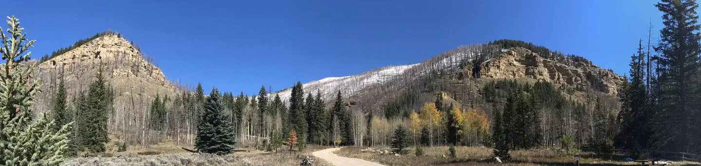
Old Folks Flat Campground is nestled in beautiful Huntington Canyon along the Huntington Canyon National Scenic Byway on Utah Highway 31. It sits at an elevation of 8,600 feet. Many recreational activities are available, including hiking, biking and fishing. This small campground is accessible by paved road by all types of passenger vehicles.
Recreation
Popular activities include fishing, hunting, hiking, mountain biking, horseback riding, rock climbing and scenic driving. Nearby Huntington Creek is a Blue Ribbon fishery, offering high-quality fishing for brown, cutthroat and rainbow trout.The 4-mile Left Fork of the Huntington National Recreation Trail is nearby and open to hikers and horseback riders. The 10-mile Fish Creek Trail, for hiking, biking and horseback riding, is also close by.
Facilities
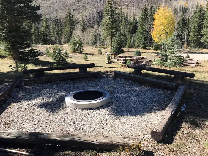
This campground is primarily devoted to group sites, but eight single-family campsites are also available. The five group sites can accommodate up to 20, 50 or 60 people and multiple vehicles in adjacent parking areas.Sites are equipped with tables and and a campfire rings with grills. The facility has recently been upgraded with flush toilets and drinking water spigots, but electricity and garbage collection service is not available. Roads and parking spurs within the campground are gravel.
Natural Features
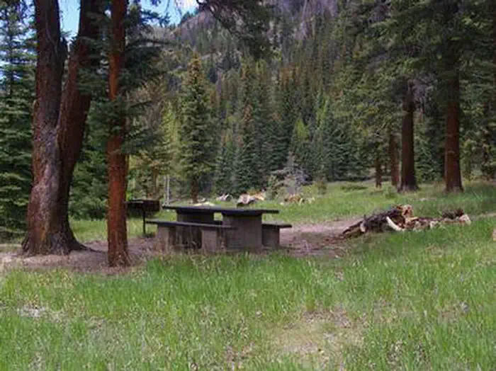
Large spruce trees and aspens cover the campground, offering partial shade. The canyon area has numerous lakes and streams, vibrant summer wildflowers, colorful fall foliage and abundant wildlife. Located just across W State Road 31 is Huntington Creek.
Nearby Attractions
The Huntington Canyon National Scenic Byway is part of the 86-mile Energy Loop. It offers stunning mountain and lake views as it tops 10,000 feet in elevation.
The historic Stuart Guard Station Visitor Center is nearby, offering a glimpse of the 1930s life of a ranger and his family who once lived there. Exhibits of Civilian Conservation Corps projects and original equipment are also on display. Area information is available there as well.
The Bridges Campground, Little Rock Campground, and Huntington Creek are also close by.
The facts
- Season: Mid-May – End September — USDA Forest Service, Aug 24, 2026
- 9 bookable sites
- 16 sites in total, including non-bookable
- Vehicles up to 35 ft
- Up to 60 people per site
- Loops: MANAGEMENT SITES, OLD, Scan and Pay
Site types
- 7 Management
- 5 Group Standard Nonelectric
- 4 Standard Nonelectric
Amenities
- Campfires allowed
- Fire pits
- Picnic tables
- Grills
- Shade
- Pets allowed
Not recorded upstream: electric hookups, water hookups, sewer hookups.
16 campsites at Old Folks Flat
| Site | Loop | Type | Entry | Surface | Access | Max rig | People | |
|---|---|---|---|---|---|---|---|---|
| XXX1 | MANAGEMENT SITES | Management | — | — | — | — | — | |
| XXX2 | MANAGEMENT SITES | Management | — | — | — | — | — | |
| XXX3 | MANAGEMENT SITES | Management | — | — | — | — | — | |
| XXX4 | MANAGEMENT SITES | Management | — | — | — | — | — | |
| 001 | OLD | Group Standard Nonelectric | Back In | Gravel | — | 30 ft | 50 | 🐾 |
| 002 | OLD | Standard Nonelectric | Pull Through | Gravel | — | 30 ft | 6 | 🐾 |
| 003 | OLD | Group Standard Nonelectric | — | Gravel | — | 28 ft | 50 | 🐾 |
| 004 | OLD | Standard Nonelectric | Back In | Gravel | — | 20 ft | 4 | 🐾 |
| 005 | OLD | Group Standard Nonelectric | Back In | Gravel | Hike In | 20 ft | 50 | 🐾 |
| 006 | OLD | Standard Nonelectric | Back In | Gravel | — | 20 ft | 6 | 🐾 |
| 007 | OLD | Group Standard Nonelectric | Back In | Gravel | — | 30 ft | 60 | 🐾 |
| 008 | OLD | Standard Nonelectric | Back In | Gravel | — | 20 ft | 6 | 🐾 |
| 009 | OLD | Group Standard Nonelectric | Back In | Gravel | — | 30 ft | 20 | 🐾 |
| XXX | OLD | Management | Back In | Gravel | — | 35 ft | 8 | |
| ScanPay 1 | Scan and Pay | Management | Back In | — | — | — | 0 | |
| ScanPay 2 | Scan and Pay | Management | Back In | — | — | — | 0 |
Getting there
39.53889, -111.15889 · 39°32'20.0"N 111°9'32.0"W
Typical weather
Typically 74°F in Jul, down to 25°F in Dec.
| Jan | Feb | Mar | Apr | May | Jun | Jul | Aug | Sep | Oct | Nov | Dec | |
|---|---|---|---|---|---|---|---|---|---|---|---|---|
| High °F | 27 | 31 | 38 | 43 | 55 | 66 | 74 | 72 | 63 | 48 | 35 | 25 |
| Low °F | 4 | 3 | 10 | 18 | 27 | 35 | 41 | 40 | 32 | 22 | 15 | 2 |
| Precip in | 2.8 | 2.5 | 2.3 | 2.8 | 2.0 | 1.0 | 1.0 | 1.6 | 1.7 | 1.9 | 2.1 | 2.7 |
1991–2020 averages from the nearest NOAA station, 5.1 mi away — not measured at the facility itself, and elevation can make a real difference over that distance.
Map
More photos
Member photos
Common questions about Old Folks Flat
- Can you reserve a site at Old Folks Flat?
- Yes, Old Folks Flat is reservable through Recreation.gov.
- How many campsites does Old Folks Flat have?
- 16 sites in total, of which 9 can be booked.
- What is the maximum RV length at Old Folks Flat?
- 35 ft. That is the longest vehicle the sites here are recorded as taking; individual sites may be shorter.
- Are pets allowed at Old Folks Flat?
- Yes, pets are allowed at Old Folks Flat.
- Are campfires allowed at Old Folks Flat?
- Campfires are allowed at Old Folks Flat. Check for a current fire restriction before you go.
Also listed by
Old Folks Flat also appears in other federal recreation data. Facts below are matched by name and location, not confirmed by Old Folks Flat's operator.
USDA Forest Service — data as of Aug 24, 2026
- 4 Single Sites - $10 Per Night 5 Group Sites - $30-$75 Per Night
Restrictions:
- ATVs/OHVs are not permitted in this campground. If they are brought in, they need to remain on trailers or in vehicles.
- Horses are not permitted in the campground, but are allowed to pass through the edge of the campground on a non-motorized trail.
- See Forest Camping and Travel Rules under Quick Links at right.
Camping near Old Folks Flat
- Little Rock Campground 0.5 mi · Campground · we watch it
- Chute Group 1.3 mi · Campground · we watch it
- Bridges Campground 1.5 mi · Campground · we watch it
- Big Rock Group 1.8 mi · Campground · we watch it
- Forks of Huntington 2.6 mi · Campground · we watch it
- Miller Flat Reservoir Campground 5 mi · Campground · we watch it
- Cleveland Reservoir Campground 5.3 mi · Campground · we watch it
- Bridges Campground 0.7 mi · Campground
- Huntington Canyon Recreation Area 2.2 mi · Facility
- Chute Group Campground 2.5 mi · Campground
- Miller Flat Reservoir Campground 5 mi · Facility
- Candland Mountain Trailhead 5.2 mi · Facility
Contact
- Phone 435-384-2372
- Book Recreation.gov
Recreation.gov last updated this record on 2026-02-25.
Facility information and photographs from Recreation.gov (RIDB). SpotOpened is not affiliated with Recreation.gov or any federal agency.
Comments