Maple Canyon
Campground · Utah · 15 bookable sites ·
Managed by the USDA Forest Service
Uinta National Forest (NF) · Open Access
- 15
- Bookable sites
- 30 ft
- Max rig length
- up to 25
- People per site
- 6,915 ft
- Elevation
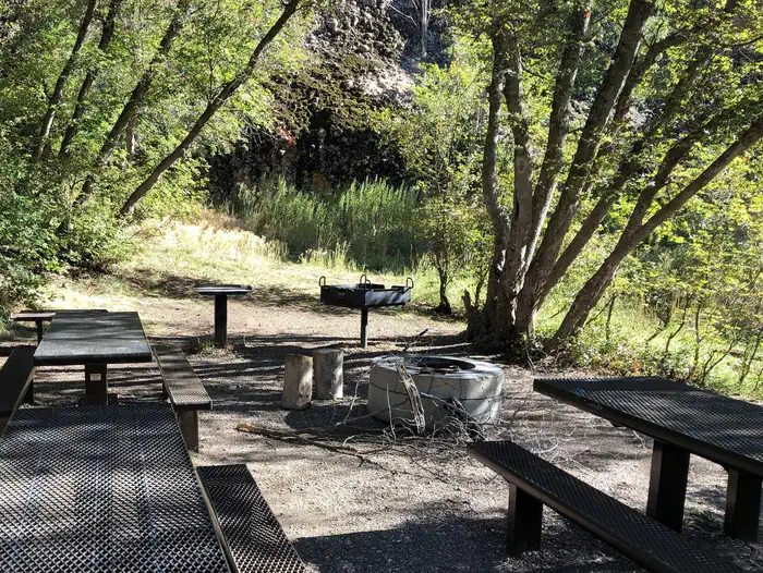
Overview
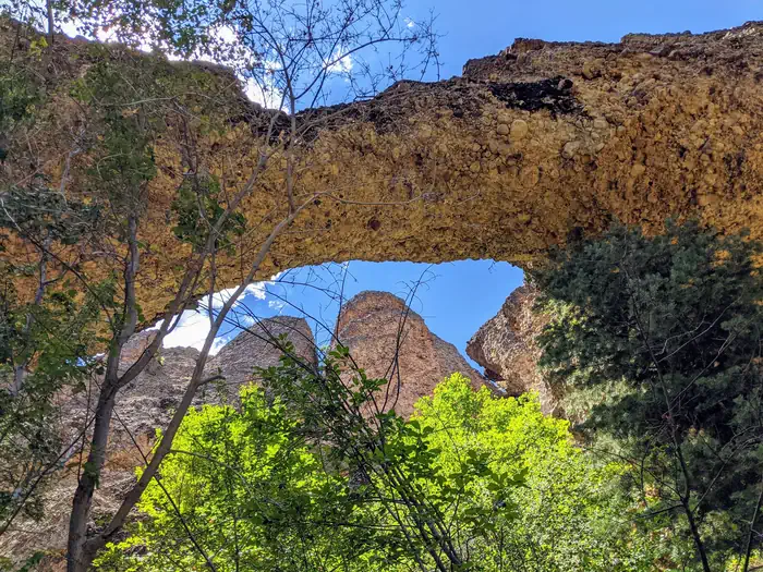
Maple Canyon Campground is known for its unique cliffs, arches, and scenic views of the Sanpitch Mountains. It is a small campground nestled between towering conglomerate rock walls on either side of the canyon. A favorite among rock climbers, notably for a formation called The Pipe Dream, the campground is just 3 miles from Freedom, Utah.
Recreation
Rock climbing is the campground's main draw, attracting climbers from all over the world with its numerous routes for beginners and experts alike.Over 140 bolted routes are available with climbing grades from 5.4 to 5.14.
Facilities
The campground contains one group site and several single-family sites. Sites 2, 3 and 4 are walk-to tent sites that must be accessed by carrying gear a short distance from the parking area. Vault toilets are provided but there is no water. Roads and parking spurs are dirt. Accessible by all passenger vehicles.
Natural Features
The campground is nestled among thick groves of maples below beautiful, towering conglomerate walls at an elevation of 6,700 feet. The canyon contains over 40 cliffs ranging in height from 30 to 300 feet. A variety of wildlife makes its home in the canyon.Nearby Attractions
The canyon offers some excellent hiking, biking and horseback riding opportunities. Three steep scenic loop trails (three to five-mile loops) provide access to many of the rock climbing sites in the canyon, such as the famous Pipe Dream tunnel. Panoramic views east into Sanpete Valley and beyond to the Wasatch Plateau reveal themselves near the tops of the trails and cliffs. The Sanpitch Recreation Area and Chicken Creek Campground can be found nearby.
The facts
- Season: May – October 18 — USDA Forest Service, Aug 24, 2026
- 15 bookable sites
- 19 sites in total, including non-bookable
- Vehicles up to 30 ft
- Up to 25 people per site
- Loops: FAM, Scan and Pay
Site types
- 10 Standard Nonelectric
- 4 Management
- 4 Walk To
- 1 Group Standard Nonelectric
Amenities
- Campfires allowed
- Fire pits
- Picnic tables
- Grills
- Pets allowed
Not recorded upstream: electric hookups, water hookups, sewer hookups, shade.
19 campsites at Maple Canyon
| Site | Loop | Type | Entry | Surface | Max rig | People | |
|---|---|---|---|---|---|---|---|
| 001 | FAM | Group Standard Nonelectric | Back In | Gravel | 20 ft | 25 | 🐾 |
| 002 | FAM | Walk To | Back In | Gravel | — | 6 | 🐾 |
| 003 | FAM | Walk To | Back In | Gravel | — | 6 | 🐾 |
| 004 | FAM | Walk To | Back In | Gravel | — | 6 | 🐾 |
| 005 | FAM | Management | Back In | Gravel | 30 ft | 8 | |
| 006 | FAM | Standard Nonelectric | Back In | Gravel | 20 ft | 6 | 🐾 |
| 007 | FAM | Standard Nonelectric | Back In | Gravel | 20 ft | 6 | 🐾 |
| 008 | FAM | Standard Nonelectric | Back In | Gravel | 20 ft | 6 | 🐾 |
| 009 | FAM | Standard Nonelectric | Back In | Gravel | 25 ft | 6 | |
| 010 | FAM | Standard Nonelectric | Back In | Gravel | 20 ft | 6 | 🐾 |
| 011 | FAM | Standard Nonelectric | Back In | Gravel | 15 ft | 8 | 🐾 |
| 012 | FAM | Walk To | Back In | Gravel | — | 6 | 🐾 |
| 013 | FAM | Standard Nonelectric | Back In | Gravel | 20 ft | 6 | 🐾 |
| 014 | FAM | Standard Nonelectric | Back In | Gravel | 20 ft | 6 | 🐾 |
| 015 | FAM | Standard Nonelectric | Back In | Gravel | 20 ft | 6 | 🐾 |
| 016 | FAM | Standard Nonelectric | Back In | Gravel | 20 ft | 6 | 🐾 |
| ScanPay 1 | Scan and Pay | Management | Back In | — | — | 0 | |
| ScanPay 2 | Scan and Pay | Management | Back In | — | — | 0 | |
| ScanPay 3 | Scan and Pay | Management | Back In | — | — | 0 |
Getting there
From Moroni go 9 miles west, following the signs for Maple Canyon.
39.55694, -111.68639 · 39°33'25.0"N 111°41'11.0"W
Typical weather
| Jan | Feb | Mar | Apr | May | Jun | Jul | Aug | Sep | Oct | Nov | Dec | |
|---|---|---|---|---|---|---|---|---|---|---|---|---|
| High °F | — | — | — | — | — | — | — | — | — | — | — | — |
| Low °F | — | — | — | — | — | — | — | — | — | — | — | — |
| Precip in | 2.8 | 2.5 | 2.1 | 2.6 | 2.0 | 0.8 | 1.0 | 1.0 | 1.7 | 2.3 | 2.2 | 2.9 |
1991–2020 averages from the nearest NOAA station, 4.6 mi away — not measured at the facility itself, and elevation can make a real difference over that distance.
Map
More photos

Member photos
Common questions about Maple Canyon
- Can you reserve a site at Maple Canyon?
- Yes, Maple Canyon is reservable through Recreation.gov.
- How many campsites does Maple Canyon have?
- 19 sites in total, of which 15 can be booked.
- What is the maximum RV length at Maple Canyon?
- 30 ft. That is the longest vehicle the sites here are recorded as taking; individual sites may be shorter.
- Are pets allowed at Maple Canyon?
- Yes, pets are allowed at Maple Canyon.
- Are campfires allowed at Maple Canyon?
- Campfires are allowed at Maple Canyon. Check for a current fire restriction before you go.
Also listed by
Maple Canyon also appears in other federal recreation data. Facts below are matched by name and location, not confirmed by Maple Canyon's operator.
USDA Forest Service — data as of Aug 24, 2026
- $10 per night for single site, $40 per night for a group site. $5/per vehicle for trailhead parking.
Camping near Maple Canyon
- Ponderosa Uinta 14.5 mi · Campground · we watch it
- Bear Canyon 16.1 mi · Campground · we watch it
- Lake Hill 18.8 mi · Campground · we watch it
- Seely Creek Guard Station 21.8 mi · Campground · we watch it
- Manti Community 22.4 mi · Campground · we watch it
- Mammoth Cabin 22.4 mi · Campground · we watch it
- Gooseberry Creek Campground 22.6 mi · Campground · we watch it
- Lake Canyon Rec Area 22.8 mi · Campground · we watch it
- Chicken Creek Campground 5 mi · Campground
- Cottonwood Campground 15.6 mi · Campground
- Mt. Nebo Scenic Byway 19.4 mi · Facility
- Lake Cabin 22.4 mi · Campground
Contact
- Phone 435-283-4151
- Book Recreation.gov
Recreation.gov last updated this record on 2026-02-25.
Facility information and photographs from Recreation.gov (RIDB). SpotOpened is not affiliated with Recreation.gov or any federal agency.
Comments