Newspaper Rock
Facility ·
Managed by the Bureau of Land Management
Bears Ears National Monument · Open Access
- 6,143 ft
- Elevation
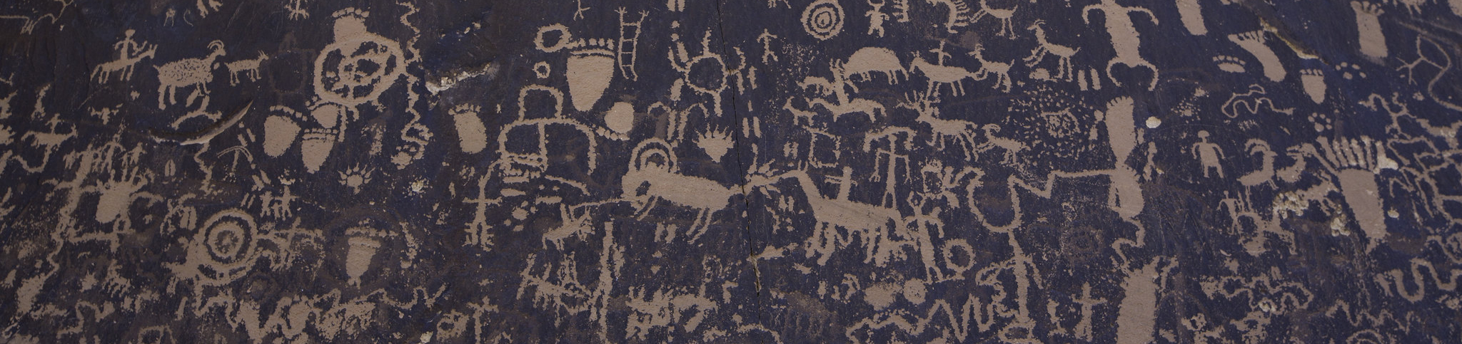
Newspaper Rock is an impressive petroglyph site located along Indian Creek in southeastern Utah. This panel displays multiple periods of imagery from cultures dating from 1500 years ago to this century. The older art is attributed to the Basketmaker and Ancestral Puebloan people who inhabited this region from approximately 500 B.C. to 1350 A.D. The more recent petroglyphs (lighter in color) are attributed to the Ute people who still live in the Four Corners area. This popular day-use site has toilet facilities and ample paved parking, including pull-through spaces for larger vehicles and RVs.
At the other end of the parking area from the toilets is a short compacted-gravel path that leads to the petroglyph panel where there is some interpretative information.
Getting there
Newspaper Rock is located on Highway 211, which starts 15 miles north of Monticello, Utah. Drive 13 miles west on Highway 211. The site is well signed.
37.98842, -109.51827 · 37°59'18.3"N 109°31'5.8"W
Typical weather
| Jan | Feb | Mar | Apr | May | Jun | Jul | Aug | Sep | Oct | Nov | Dec | |
|---|---|---|---|---|---|---|---|---|---|---|---|---|
| High °F | — | — | — | — | — | — | — | — | — | — | — | — |
| Low °F | — | — | — | — | — | — | — | — | — | — | — | — |
| Precip in | 2.4 | 2.7 | 2.3 | 1.8 | 1.7 | 0.7 | 2.9 | 3.1 | 2.3 | 1.9 | 2.3 | 2.7 |
1991–2020 averages from the nearest NOAA station, 9 mi away — not measured at the facility itself, and elevation can make a real difference over that distance.
Map
Fees and stay limits
There is no fee for this site.
From Recreation.gov, which is not always current. The operator's own page is the authority on what you will be charged.
Member photos
Common questions about Newspaper Rock
- Can you reserve a site at Newspaper Rock?
- No. Newspaper Rock is not reservable through Recreation.gov, so sites are first-come, first-served or booked elsewhere.
Camping near Newspaper Rock
- Buckboard 8.3 mi · Campground · we watch it
- Superbowl Group Site 12.2 mi · Campground · we watch it
- Superbowl Campground 12.3 mi · Campground · we watch it
- Windwhistle Group Site 13.4 mi · Campground · we watch it
- Creek Pasture Campground 13.7 mi · Campground · we watch it
- Creek Pasture Group Site 14.1 mi · Campground · we watch it
- Nizhoni 14.3 mi · Campground · we watch it
- Hamburger Rock Campground 16.3 mi · Campground · we watch it
- Foy Lake Fishing/Camping Site 6 mi · Campground
- Monticello Lake Fishing Site 7 mi · Facility
- Dalton Springs Campground 9.1 mi · Campground
- Windwhistle Campground 13.3 mi · Campground
Contact
- Phone 435-587-1500
- Email utmtmail@blm.gov
- Info Recreation.gov
Recreation.gov last updated this record on 2026-03-26.
Facility information and photographs from Recreation.gov (RIDB). SpotOpened is not affiliated with Recreation.gov or any federal agency.
Comments