Piney Point
Campground · Texas · 53 bookable sites ·
Managed by the US Army Corps of Engineers
Wright Patman Recreation Area (REC) · Open Access
- 53
- Bookable sites
- 55 ft
- Max rig length
- up to 75
- People per site
- 5
- Accessible sites
- 291 ft
- Elevation
Overview
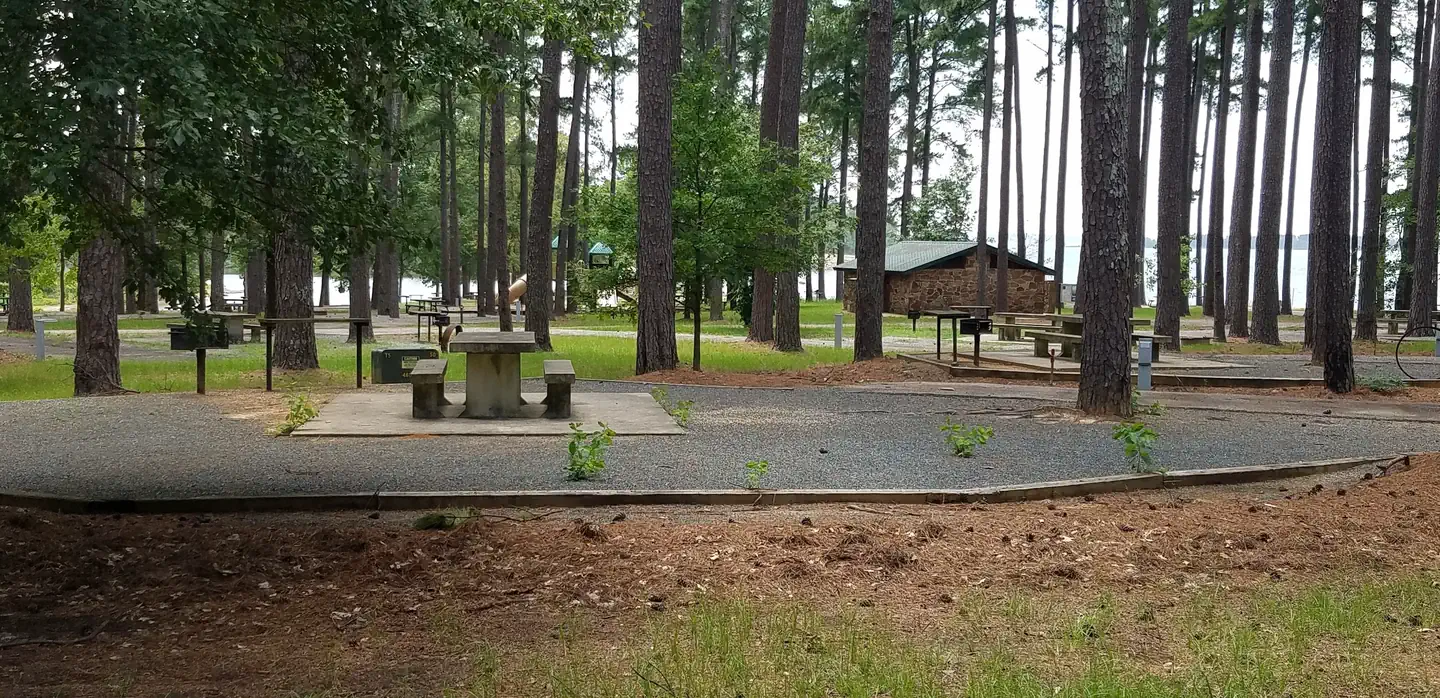
Piney Point Park is situated on the shore of 30,000-acre Wright Patman Lake within the piney woods of northeast Texas. This facility offers campers a complete range of services and year-round outdoor activities like fishing, hunting and wildlife viewing.Recreation
Piney Point has plenty of open space and shade in which children can play, as well as a volleyball court and a 1.3-mile hiking trail that leads to nearby Rocky Point Campground and its swimming beach.Other activities on the lake include boating, fishing, hunting, picnicking and wildlife viewing. Boaters can make use of the park's boat ramp, and anglers can try their luck for bass, catfish, crappie and sunfish.
Facilities
The campground has comfortable accommodations with 45 campsites with water and electricity, as well as a group picnic shelter for day use only that can host up to 75 people. Campsites have picnic tables, grills, utility tables and trash cans. Restrooms, showers and a dump station are provided.Natural Features
The park is located in a southern pine forest overlooking the lake. The U.S. Army Corps of Engineers manages approximately 55,000 acres of public forestland around the lake, providing habitat for wild turkey, bobwhite quail, squirrel, white-tailed deer, waterfowl and migrating bald eagles, pelicans and ducks. Some poisonous snakes inhabit the area.Nearby Attractions
The Texarkana region is full of activities such as shopping, movies, restaurants and local historical sites. Shreveport, Louisiana offers river boat gambling, horse races and numerous festivals, including the Four State Fair and Rodeo and the Jump, Jive and Jam Festival.The facts
- 53 bookable sites
- 1 site for day use only
- 5 accessible sites
- Vehicles up to 55 ft
- Up to 75 people per site
- Loops: ALOO, B, DUSS
Site types
- 45 Standard Electric
- 7 Tent Only Nonelectric
- 1 Group Picnic Area
Amenities
- Electric hookups
- Water hookups
- Campfires allowed
- Fire pits
- Picnic tables
- Grills
- Shade
- Pets allowed
Not recorded upstream: sewer hookups.
53 campsites at Piney Point
| Site | Loop | Type | Entry | Surface | Max rig | People | |
|---|---|---|---|---|---|---|---|
| A01 | ALOO | Standard Electric | Back In | Paved | 45 ft | 10 | 🐾 |
| A02 | ALOO | Standard Electric | Pull Through | Paved | 50 ft | 10 | 🐾 |
| A03 | ALOO | Standard Electric | Back In | Paved | 45 ft | 10 | 🐾 |
| A04 | ALOO | Standard Electric | Back In | Paved | 50 ft | 10 | 🐾 |
| A05 | ALOO | Standard Electric | Back In | Paved | 45 ft | 10 | 🐾 |
| A06 | ALOO | Standard Electric | Back In | Paved | 35 ft | 10 | 🐾 |
| A07 | ALOO | Standard Electric | Back In | Paved | 50 ft | 10 | 🐾 |
| A08 | ALOO | Standard Electric | Back In | Paved | 50 ft | 10 | 🐾 |
| A09 | ALOO | Standard Electric | Back In | Paved | 55 ft | 10 | 🐾 |
| A10 | ALOO | Standard Electric | Back In | Paved | 40 ft | 10 | 🐾 |
| A11 | ALOO | Standard Electric | Back In | Paved | 50 ft | 10 | 🐾 |
| A12 | ALOO | Standard Electric | Back In | Paved | 50 ft | 10 | 🐾 |
| A13 | ALOO | Standard Electric | Back In | Paved | 40 ft | 10 | 🐾 |
| A14 | ALOO | Standard Electric | Back In | Paved | 50 ft | 10 | 🐾 |
| A15 | ALOO | Standard Electric | Back In | Paved | 45 ft | 10 | 🐾 |
| A19 | ALOO | Standard Electric | Back In | — | 50 ft | 10 | 🐾 |
| A20 | ALOO | Standard Electric | Back In | Paved | 40 ft | 10 | 🐾 |
| A21 | ALOO | Standard Electric | Back In | Paved | 50 ft | 10 | 🐾 |
| A22 | ALOO | Standard Electric | Back In | Paved | 40 ft | 10 | ♿ 🐾 |
| A23 | ALOO | Standard Electric | Back In | Paved | 50 ft | 10 | 🐾 |
| A24 | ALOO | Standard Electric | Back In | Paved | 45 ft | 10 | ♿ 🐾 |
| A25 | ALOO | Standard Electric | Back In | Paved | 50 ft | 10 | 🐾 |
| A26 | ALOO | Standard Electric | Back In | Paved | 50 ft | 10 | 🐾 |
| A27 | ALOO | Standard Electric | Back In | Paved | 45 ft | 10 | 🐾 |
| A28 | ALOO | Standard Electric | Back In | Paved | 45 ft | 10 | ♿ 🐾 |
| A29 | ALOO | Standard Electric | Back In | Paved | 40 ft | 10 | ♿ 🐾 |
| A30 | ALOO | Standard Electric | Back In | Paved | 40 ft | 10 | 🐾 |
| A31 | ALOO | Standard Electric | Pull Through | Paved | 50 ft | 10 | 🐾 |
| A32 | ALOO | Standard Electric | Back In | Paved | 50 ft | 10 | 🐾 |
| A33 | ALOO | Standard Electric | Back In | Paved | 35 ft | 10 | 🐾 |
| A34 | ALOO | Standard Electric | Back In | Paved | 45 ft | 10 | 🐾 |
| A35 | ALOO | Standard Electric | Back In | Paved | 35 ft | 10 | 🐾 |
| A36 | ALOO | Standard Electric | Pull Through | Paved | 40 ft | 10 | 🐾 |
| A37 | ALOO | Standard Electric | Pull Through | Paved | 40 ft | 10 | 🐾 |
| A38 | ALOO | Standard Electric | Back In | Paved | 40 ft | 10 | 🐾 |
| A39 | ALOO | Standard Electric | Pull Through | Paved | 40 ft | 10 | 🐾 |
| A40 | ALOO | Standard Electric | Back In | Paved | 40 ft | 10 | 🐾 |
| A41 | ALOO | Standard Electric | Pull Through | Paved | 45 ft | 10 | 🐾 |
| A42 | ALOO | Standard Electric | Back In | Paved | 40 ft | 10 | 🐾 |
| A43 | ALOO | Standard Electric | Pull Through | Paved | 50 ft | 10 | 🐾 |
| A44 | ALOO | Standard Electric | Back In | Paved | 45 ft | 10 | 🐾 |
| A45 | ALOO | Standard Electric | Pull Through | Paved | 40 ft | 10 | 🐾 |
| A46 | ALOO | Standard Electric | Back In | Paved | 45 ft | 10 | 🐾 |
| A47 | ALOO | Standard Electric | Back In | Paved | 50 ft | 10 | 🐾 |
| A48 | ALOO | Standard Electric | Back In | Paved | 50 ft | 10 | 🐾 |
| B01 | B | Tent Only Nonelectric | — | — | — | 10 | 🐾 |
| B02 | B | Tent Only Nonelectric | — | — | — | 10 | 🐾 |
| B03 | B | Tent Only Nonelectric | — | — | — | 10 | 🐾 |
| B04 | B | Tent Only Nonelectric | — | — | — | 10 | 🐾 |
| B05 | B | Tent Only Nonelectric | — | — | — | 10 | 🐾 |
| B06 | B | Tent Only Nonelectric | — | — | — | 10 | 🐾 |
| B07 | B | Tent Only Nonelectric | — | — | — | 10 | 🐾 |
| GS1 | DUSS | Group Picnic Area | — | — | — | 75 | ♿ 🐾 |
Getting there
Physical Address of Piney Point Park:
710 Piney Point Park Road
Queen City, TX 75572
From Texarkana, take Highway 59 south to Wright Patman Lake. Just south of Sulphur River Dam, turn right into the park area, following signs. Proceed one mile to the park. Piney Point is just north of Rocky Point Park.
33.29861, -94.16806 · 33°17'55.0"N 94°10'5.0"W
Typical weather
Typically 92°F in Jul, down to 54°F in Jan.
| Jan | Feb | Mar | Apr | May | Jun | Jul | Aug | Sep | Oct | Nov | Dec | |
|---|---|---|---|---|---|---|---|---|---|---|---|---|
| High °F | 54 | 59 | 66 | 74 | 81 | 88 | 92 | 92 | 87 | 76 | 64 | 56 |
| Low °F | 35 | 39 | 46 | 54 | 63 | 71 | 74 | 73 | 66 | 54 | 44 | 38 |
| Precip in | 4.1 | 4.5 | 4.6 | 4.2 | 5.2 | 4.4 | 3.6 | 3.2 | 3.3 | 4.3 | 4.4 | 4.8 |
1991–2020 averages from the nearest NOAA station, 0.7 mi away — not measured at the facility itself, and elevation can make a real difference over that distance.
Map
More photos
Member photos
Common questions about Piney Point
- Can you reserve a site at Piney Point?
- Yes, Piney Point is reservable through Recreation.gov.
- How many campsites does Piney Point have?
- 53 sites.
- What is the maximum RV length at Piney Point?
- 55 ft. That is the longest vehicle the sites here are recorded as taking; individual sites may be shorter.
- Are pets allowed at Piney Point?
- Yes, pets are allowed at Piney Point.
- Does Piney Point have hookups?
- Electric, Water.
- Are campfires allowed at Piney Point?
- Campfires are allowed at Piney Point. Check for a current fire restriction before you go.
Camping near Piney Point
- Rocky Point(wright Patman Dam) 0.8 mi · Campground · we watch it
- Oak Park (Wright Patman Lake) 1.7 mi · Campground · we watch it
- Sportsman's Cove 4.1 mi · Campground · we watch it
- North Shore 4.1 mi · Campground · we watch it
- Clear Springs (TX) 4.3 mi · Campground · we watch it
- Malden Lake Campground 10.5 mi · Campground · we watch it
- Beard's Bluff Park (Ar) 31.2 mi · Campground · we watch it
- White Cliffs Park 32.8 mi · Campground · we watch it
- Paraloma Park 35.1 mi · Campground · we watch it
- Cottonshed Park (Ar) 36.4 mi · Campground · we watch it
- Johnson Creek Day Use 41.5 mi · Campground · we watch it
- President William Jefferson Clinton Birthplace Home National Historic Site Visitor Center 41.7 mi · Facility
Contact
- Phone 903-796-0684
- Book Recreation.gov
Recreation.gov last updated this record on 2026-02-25.
Facility information and photographs from Recreation.gov (RIDB). SpotOpened is not affiliated with Recreation.gov or any federal agency.
Comments