Shutes Branch
Campground · Tennessee · 1 bookable site ·
Managed by the US Army Corps of Engineers
Shutes Branch Rec Area (NRA) · Open Access
- 1
- Bookable site
- up to 50
- People per site
- 464 ft
- Elevation
Overview
Shutes Branch is located on the popular Old Hickory Lake, just a short drive outside of Nashville. There's plenty of opportunities for boating, biking, swimming and fishing, as well as sailing.Recreation
Bikers of all skills levels will enjoy the Shutes Branch Mountain Biking Trail, accessed from the picnic area. The first part of the trail is ideal for beginners, while the second portion will challenge more experienced cyclists with rockier terrain, ledges and tight turns.With its close vicinity to the water, Fishing and swimming are consistently popular activities at Shutes Branch.
Facilities
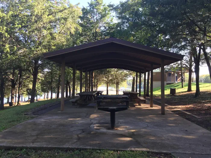
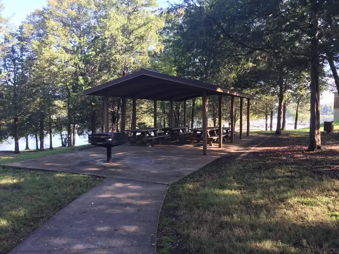
Shutes Branch offers various picnic sites, a boat launch and fishing platform.The reservable group picnic shelter holds 50 guests and comes with electric hookups.
Natural Features
Old Hickory Lake is a 22,500 acre reservoir created by the Old Hickory Lock and Dam on the Cumberland River. The lake is named after former president Andrew Jackson, a Tennessee-native nicknamed "Old Hickory" for his tough and aggressive personality.The lake features 440 miles of scenic shoreline, surrounded by wooded flatlands and plenty of access points.
Nearby Attractions
Nearby fishing piers attract anglers at Rockland, Sanders Ferry, Shutes Branch and Bledsoe Creek State Park.History buffs will enjoy a day trip to The Hermitage, a National Historic Landmark and home of former president, Andrew Jackson, during the early 19th century.
The facts
- 1 bookable site
- 1 site for day use only
- Up to 50 people per site
- Loops: GROUP SITE
Site types
- 1 Group Shelter Electric
Amenities
- Electric hookups
- Water hookups
- Picnic tables
- Shade
Not recorded upstream: sewer hookups, campfires allowed, fire pits, grills, pets allowed.
1 campsite at Shutes Branch
Check-in 6:00 AM · Check-out 7:00 PM
| Site | Loop | Type | Entry | Surface | Max rig | People | |
|---|---|---|---|---|---|---|---|
| S36 | GROUP SITE | Group Shelter Electric | — | Paved | — | 50 |
Getting there
From downtown Nashville get on I-40 E/I-65 S for .9 miles. Follow I-40 E for 12.2 miles and then take exit 221A from I-40 E. Take Andrew Jackson Pkwy which turns into Saundersville Rd for 6.5 miles. Shutes Branch Recreation Area will be located on the right side of the road.
36.24768, -86.57027 · 36°14'51.6"N 86°34'13.0"W
Typical weather
Typically 89°F in Jul, down to 46°F in Jan.
| Jan | Feb | Mar | Apr | May | Jun | Jul | Aug | Sep | Oct | Nov | Dec | |
|---|---|---|---|---|---|---|---|---|---|---|---|---|
| High °F | 46 | 51 | 60 | 70 | 78 | 85 | 89 | 88 | 82 | 72 | 59 | 50 |
| Low °F | 28 | 30 | 38 | 47 | 56 | 65 | 68 | 67 | 61 | 49 | 38 | 32 |
| Precip in | 4.3 | 4.7 | 4.9 | 5.2 | 5.4 | 4.4 | 4.8 | 4.6 | 4.0 | 3.5 | 4.0 | 4.8 |
1991–2020 averages from the nearest NOAA station, 0.4 mi away — not measured at the facility itself, and elevation can make a real difference over that distance.
Map
More photos
Member photos
Common questions about Shutes Branch
- Can you reserve a site at Shutes Branch?
- Yes, Shutes Branch is reservable through Recreation.gov.
- How many campsites does Shutes Branch have?
- 1 site.
- Does Shutes Branch have hookups?
- Electric, Water.
Camping near Shutes Branch
- Cedar Creek (TN) 3.9 mi · Campground · we watch it
- Lone Branch 4.7 mi · Campground · we watch it
- Cages Bend 4.9 mi · Campground · we watch it
- Avondale 5.5 mi · Campground · we watch it
- Rockland Recreation Area 5.7 mi · Campground · we watch it
- Old Hickory Beach 5.7 mi · Campground · we watch it
- Laguardo 7.6 mi · Campground · we watch it
- Nat Caldwell Park 7.6 mi · Campground · we watch it
- Cook Day Use Area 7.8 mi · Campground · we watch it
- Seven Points (TN) 7.9 mi · Campground · we watch it
- Anderson Road Campground 10 mi · Campground · we watch it
- Smith Springs 11 mi · Campground · we watch it
Contact
- Phone 615-754-4847
- Book Recreation.gov
Recreation.gov last updated this record on 2026-02-25.
Facility information and photographs from Recreation.gov (RIDB). SpotOpened is not affiliated with Recreation.gov or any federal agency.
Comments