Link Creek
Campground · Oregon · 33 bookable sites ·
Managed by the USDA Forest Service
Deschutes National Forest (NF) · Open Access
- 33
- Bookable sites
- 50 ft
- Max rig length
- up to 12
- People per site
- 3,460 ft
- Elevation
Overview
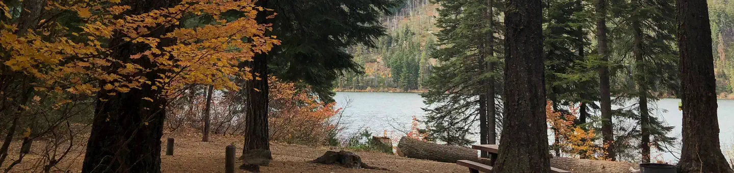
Link Creek Campground is situated on the shores of Suttle Lake in the Deschutes National Forest. Visitors enjoy boating, fishing, hiking and biking in summer, and cross-country skiing and snowshoeing in winter.Recreation
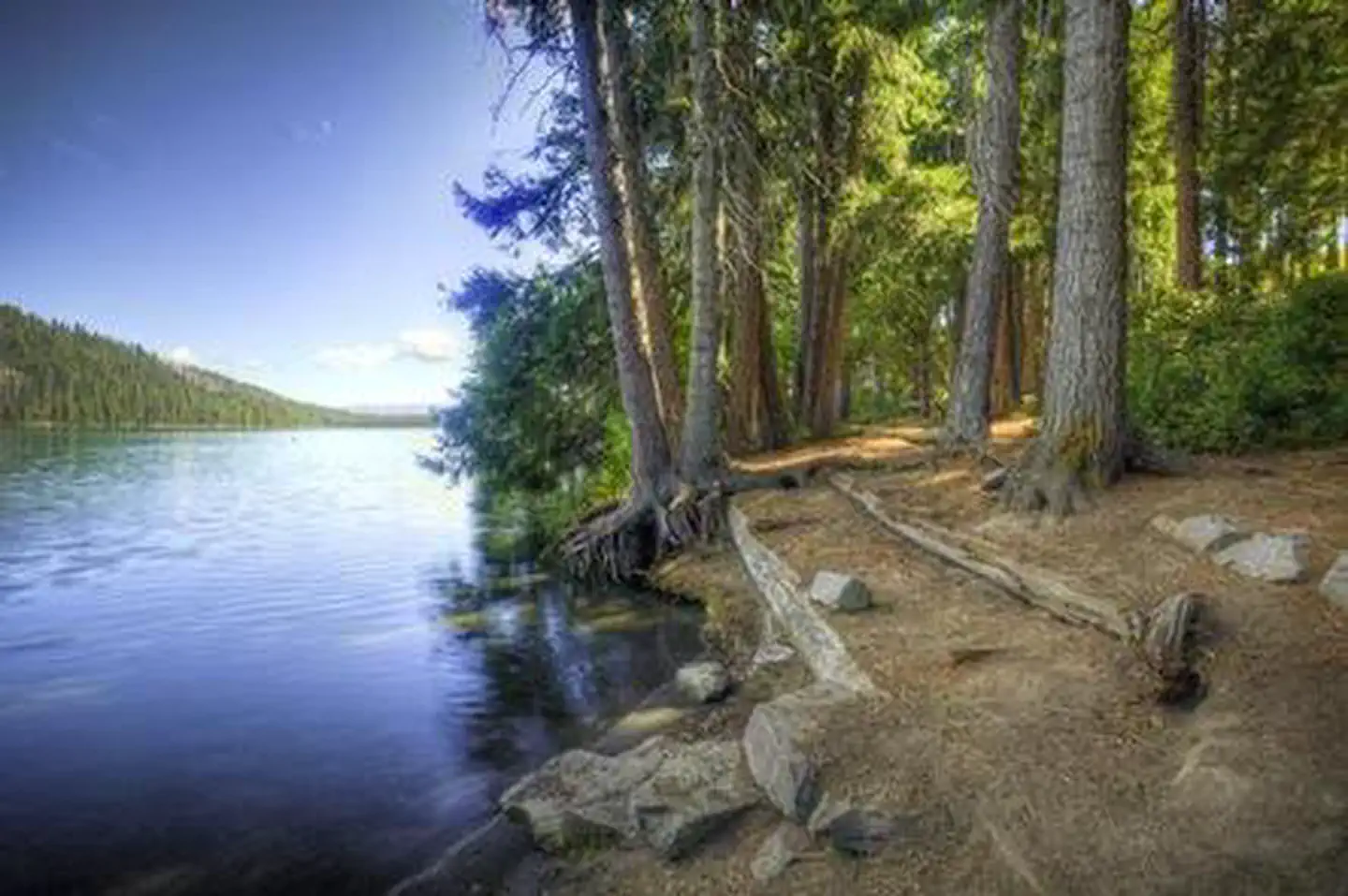
Popular activities in the area include hiking, fishing and motorized boating in the summer months, and cross-country skiing and snowshoeing in winter months. Numerous hiking mountain biking trails are accessible from the campground and in the surrounding area. The 3.2 mile Suttle Lake Loop Trail meanders through the developed recreation areas on Suttle Lake. The trail is relatively flat and follows the wooded shoreline of the lake, providing opportunities for fishing or picnicking along the way. A boat ramp is located within the campground. Motorized and non-motorized boats are allowed on Suttle Lake.Facilities
Link Creek Campground offers tent and RV campsites, as well as yurts. Campsites are equipped with tables and campfire rings with grills. Vault toilets and drinking water are provided. Electrical hookups are not available. The yurts are equipped with electricity. While the campsites are pet-friendly, unfortunately pets are not permitted within the yurts. The yurts are available for reservation year-round. Housekeeping is reduced to 2-3 days from November - March. Each is equipped with a bunkbed with one double and one single mattress, double futon, table and chairs and a wood stove. Visitors need to bring their own linens and eating essentials. They each have a light, a wall heater, and 1 - 110 electrical outlet.
Natural Features
Suttle Lake is surrounded by a mixed conifer forest. The lake is deep and clear. The lake covers an area of 253 acres and has an average depth of 44 feet. It sustains an excellent population of naturally reproducing kokanee, brown trout, whitefish, and crayfish.Link Creek, which empties into Suttle Lake, is shallow and clear enough to view spawning fish. Lake Creek flows eastward from Suttle Lake and eventually joins the Metolius River.
In autumn, the local vine maple trees display brilliant orange, red and yellow foliage.
Nearby Attractions
Visitors can explore wilderness areas, rivers, lakes and reservoirs, and approximately 1,600 miles of trails that comprise nearly 2.5 million acres within the Deschutes National Forest and the adjacent Ochoco National Forest.Visitors enjoy traveling the Cascade Lakes Scenic Byway, known as Oregon's Highway in the Sky, which climbs into the clouds on a 66-mile drive through the Cascade Range, weaving past snow-capped peaks and alpine lakes.
Charges & Cancellations
Once your reservation start date has begun, neither the Recreation.gov Contact Center nor the campground manager will be able to modify your reservation.
The facts
- Season: Tentative Opening: May 2, 2025 – October 19, 2025 — USDA Forest Service, Aug 24, 2026
- 33 bookable sites
- 34 sites in total, including non-bookable
- Vehicles up to 50 ft
- Up to 12 people per site
- Loops: AREA LINK CREEK
Site types
- 30 Standard Nonelectric
- 3 Yurt
- 1 Management
Amenities
- Campfires allowed
- Fire pits
- Picnic tables
- Grills
- Shade
- Pets allowed
Not recorded upstream: electric hookups, water hookups, sewer hookups.
34 campsites at Link Creek
Check-in 2:00 PM · Check-out 12:00 PM
| Site | Loop | Type | Entry | Surface | Water | Max rig | People | |
|---|---|---|---|---|---|---|---|---|
| 001 | AREA LINK CREEK | Standard Nonelectric | Back In | Gravel | — | 36 ft | 6 | 🐾 |
| 002 | AREA LINK CREEK | Standard Nonelectric | Pull Through | Gravel | — | 40 ft | 6 | 🐾 |
| 003 | AREA LINK CREEK | Standard Nonelectric | Pull Through | Gravel | — | 40 ft | 6 | 🐾 |
| 004 | AREA LINK CREEK | Standard Nonelectric | Pull Through | Gravel | — | 40 ft | 6 | 🐾 |
| 005 | AREA LINK CREEK | Standard Nonelectric | Pull Through | Gravel | — | 36 ft | 12 | 🐾 |
| 006 | AREA LINK CREEK | Standard Nonelectric | Pull Through | Gravel | — | 36 ft | 6 | 🐾 |
| 007 | AREA LINK CREEK | Standard Nonelectric | Back In | Gravel | — | 40 ft | 6 | 🐾 |
| 008 | AREA LINK CREEK | Standard Nonelectric | Pull Through | Gravel | — | 40 ft | 6 | 🐾 |
| 009 | AREA LINK CREEK | Standard Nonelectric | Back In | Gravel | Lakefront | 40 ft | 12 | 🐾 |
| 010 | AREA LINK CREEK | Standard Nonelectric | Back In | Gravel | Lakefront | 30 ft | 6 | 🐾 |
| 011 | AREA LINK CREEK | Standard Nonelectric | Back In | Gravel | Lakefront | 36 ft | 6 | 🐾 |
| 012 | AREA LINK CREEK | Standard Nonelectric | Back In | Gravel | Lakefront | 40 ft | 6 | 🐾 |
| 013 | AREA LINK CREEK | Standard Nonelectric | Back In | Gravel | Lakefront | 50 ft | 6 | 🐾 |
| 014 | AREA LINK CREEK | Standard Nonelectric | Back In | Paved | Lakefront | 44 ft | 6 | 🐾 |
| 015 | AREA LINK CREEK | Standard Nonelectric | Back In | Gravel | Lakefront | 40 ft | 6 | 🐾 |
| 016 | AREA LINK CREEK | Standard Nonelectric | Back In | Gravel | Lakefront | 34 ft | 6 | 🐾 |
| 017 | AREA LINK CREEK | Standard Nonelectric | Back In | Gravel | — | 32 ft | 6 | 🐾 |
| 018 | AREA LINK CREEK | Standard Nonelectric | Back In | Gravel | Lakefront | 32 ft | 6 | 🐾 |
| 019 | AREA LINK CREEK | Standard Nonelectric | Back In | Gravel | Lakefront | 30 ft | 6 | 🐾 |
| 020 | AREA LINK CREEK | Standard Nonelectric | Back In | Gravel | Lakefront | 40 ft | 6 | 🐾 |
| 021 | AREA LINK CREEK | Standard Nonelectric | Back In | Gravel | Lakefront | 40 ft | 6 | 🐾 |
| 022 | AREA LINK CREEK | Standard Nonelectric | Pull Through | Gravel | — | 40 ft | 6 | 🐾 |
| 023 | AREA LINK CREEK | Standard Nonelectric | Back In | Gravel | — | 34 ft | 6 | 🐾 |
| 024 | AREA LINK CREEK | Standard Nonelectric | Back In | Gravel | — | 32 ft | 6 | 🐾 |
| 025 | AREA LINK CREEK | Standard Nonelectric | Back In | Gravel | — | 32 ft | 6 | 🐾 |
| 026 | AREA LINK CREEK | Standard Nonelectric | Back In | Gravel | — | 32 ft | 6 | 🐾 |
| 027 | AREA LINK CREEK | Standard Nonelectric | Back In | Gravel | — | 32 ft | 6 | 🐾 |
| 028 | AREA LINK CREEK | Standard Nonelectric | Back In | Gravel | — | 32 ft | 6 | 🐾 |
| 029 | AREA LINK CREEK | Standard Nonelectric | Pull Through | Paved | — | 40 ft | 6 | 🐾 |
| 030 Host | AREA LINK CREEK | Management | Pull Through | Gravel | — | 40 ft | 6 | 🐾 |
| 033 | AREA LINK CREEK | Standard Nonelectric | Back In | Gravel | — | 32 ft | 6 | 🐾 |
| Y31 | AREA LINK CREEK | Yurt | Pull Through | Gravel | — | 40 ft | 6 | |
| Y32 | AREA LINK CREEK | Yurt | Back In | Gravel | — | 36 ft | 6 | |
| Y34 | AREA LINK CREEK | Yurt | Back In | Paved | — | 36 ft | 6 |
Getting there
44.41583, -121.75528 · 44°24'57.0"N 121°45'19.0"W
Typical weather
| Jan | Feb | Mar | Apr | May | Jun | Jul | Aug | Sep | Oct | Nov | Dec | |
|---|---|---|---|---|---|---|---|---|---|---|---|---|
| High °F | — | — | — | — | — | — | — | — | — | — | — | — |
| Low °F | — | — | — | — | — | — | — | — | — | — | — | — |
| Precip in | 12.0 | 8.0 | 8.9 | 6.6 | 4.6 | 2.8 | 0.7 | 0.6 | 2.6 | 6.4 | 11.3 | 12.7 |
1991–2020 averages from the nearest NOAA station, 5.2 mi away — not measured at the facility itself, and elevation can make a real difference over that distance.
Map
More photos
Member photos
Common questions about Link Creek
- Can you reserve a site at Link Creek?
- Yes, Link Creek is reservable through Recreation.gov.
- How many campsites does Link Creek have?
- 34 sites in total, of which 33 can be booked.
- What is the maximum RV length at Link Creek?
- 50 ft. That is the longest vehicle the sites here are recorded as taking; individual sites may be shorter.
- Are pets allowed at Link Creek?
- Yes, pets are allowed at Link Creek.
- Are campfires allowed at Link Creek?
- Campfires are allowed at Link Creek. Check for a current fire restriction before you go.
Also listed by
Link Creek also appears in other federal recreation data. Facts below are matched by name and location, not confirmed by Link Creek's operator.
USDA Forest Service — data as of Aug 24, 2026
- Single Campsite Rate: $25/night
- Double Campsite Rate: $36/night
- Premium Campsite Rate: $27/night
- Yurts (Year-Round): $64/night
- One vehicle included with reservation – Each Additional Vehicle: $10.00
Restrictions:
- Maximum site spur length is 50 feet.
- The water system will be turned on in the month of May depending on weather conditions and will be turned off no later than September 30, or upon the campground closing, whichever, is earlier to prevent potential damage from cold temperatures.
Camping near Link Creek
- Scout Lake 0.5 mi · Campground · we watch it
- South Shore 0.9 mi · Campground · we watch it
- Blue Bay 1.2 mi · Campground · we watch it
- Big Lake 6.3 mi · Campground · we watch it
- Riverside Campground (Deschutes National Forest, OR) 6.4 mi · Campground · we watch it
- Big Lake West Campground 7 mi · Campground · we watch it
- Jack Creek Campground 7 mi · Campground · we watch it
- Winter Recreation Area: Santiam Pass (Hwy 20) 4.8 mi · Facility
- Riverside Campground 6.3 mi · Campground
- Camp Sherman Campground 6.6 mi · Campground
- Allingham Campground 6.9 mi · Campground
- Smiling River Campground 7.2 mi · Campground
Contact
- Phone 541-323-1746
- Book Recreation.gov
Recreation.gov last updated this record on 2026-06-05.
Facility information and photographs from Recreation.gov (RIDB). SpotOpened is not affiliated with Recreation.gov or any federal agency.
Comments