Lake Ottawa Campground
Campground · Michigan · 31 bookable sites ·
Managed by the USDA Forest Service
Ottawa National Forest (NF) · Open Access
- 31
- Bookable sites
- up to 8
- People per site
- 1,535 ft
- Elevation
Overview
Planning a trip to the Lake Ottawa Campground? Watch for Alerts at the top of the page for any Alerts regarding this facility.
Lake Ottawa Campground is in a beautiful forested northwoods setting located 5 miles southwest of Iron River, MI, on the Iron River Ranger District.
Recreation
- Located adjacent to the Campground is Lake Ottawa, a deep cold water lake that provides fishermen with a good variety of game fish. There is a boat ramp with ample parking for trailers.
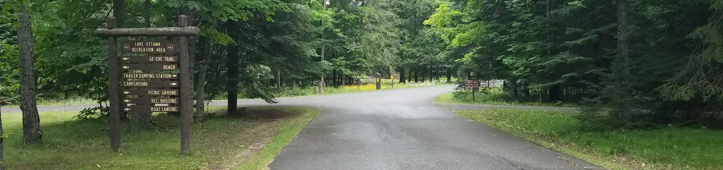
- Ge-Che Trail - Length is approximately 9 miles on a dirt trail. This trail provides scenery of primarily hardwood forest. The trail can be accessed from Lake Ottawa boat landing, and from within the campground.
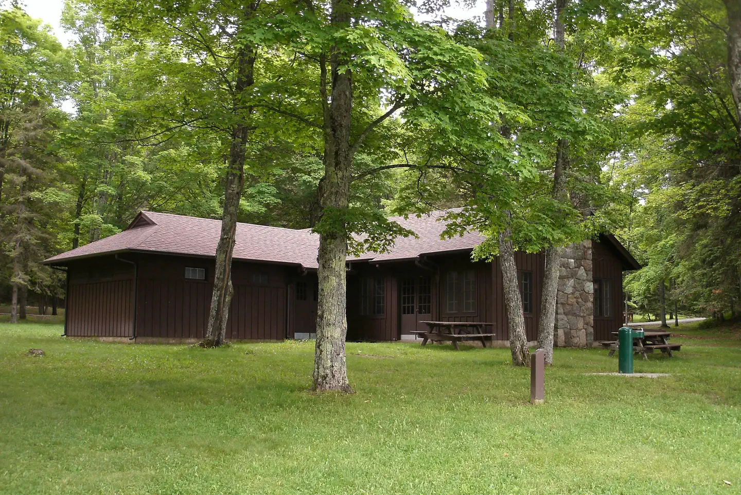
- Lake Ottawa Recreation Area day use area provides indoor facilities for a group picnic, and a large outdoor picnic area complete with picnic tables and grills. The area is large enough to provide plenty of space for all. Also located in the same area is an athletic field. The day use building provides indoor seating for eating or parties. The building has a fireplace, electricity, and flush toilets.
Facilities
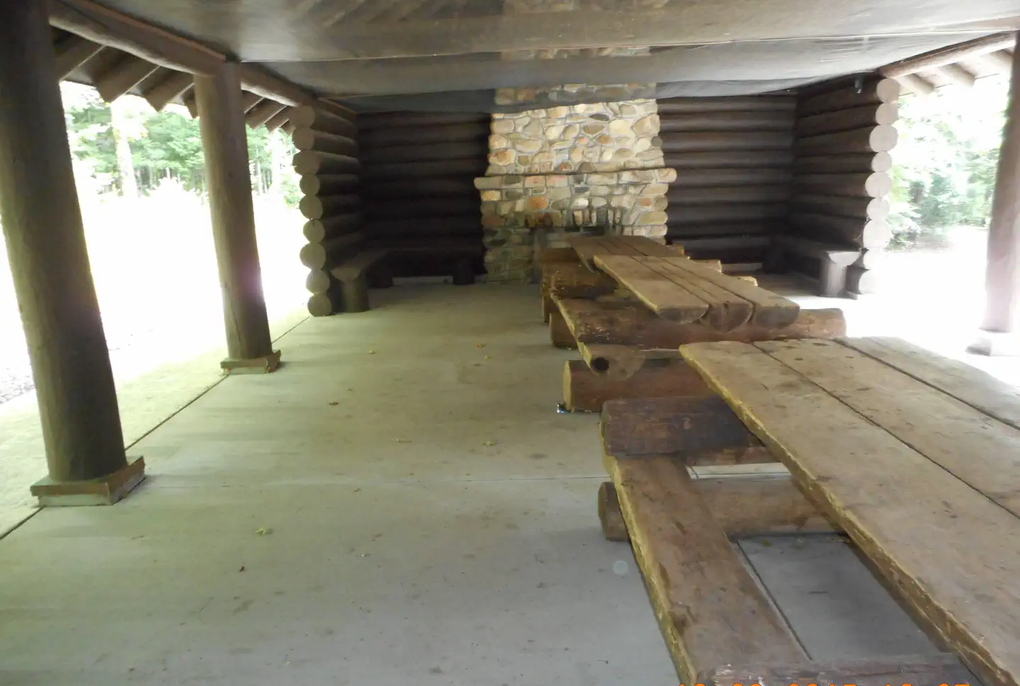
Lake Ottawa Campground is 95% surrounded by National Forest System Land and offers 32 campsites, a picnic shelter with two stone fireplaces and original log picnic tables, and two log toilet buildings with flush toilets. A pressurized water system and RV dump station are located in the campground. Adjacent to the campground, in the day use area, is a CCC era recreation building, with flush toilets, swimming beach, playing field, picnic areas and boat launch.
Nearby Attractions
- Stateline-Mile Post Zero Trail - Scenery is hardwood, forested with two destination points on the Brule River. The trail is not a loop, it is a relatively flat dirt trail. The length of the trial is approximately 4/10 of a mile and takes you to the historic Stateline Mile Post Zero location indicating the border between Michgian and Wisconsin.
- The combination of topography and thousands of miles of rivers and streams have created hundreds of waterfalls throughout the Upper Peninsula, with several of the waterfalls located on the Ottawa. The Ottawa National Forest has 18 named waterfalls, 53,637 acres of lakes, 2,366 miles of perennial streams, 2,890 miles of intermittent (occasional) streams, and 210,761 acres of wetlands. The falls vary in size and some are easier to get to than others. For more information on the most visited waterfalls on and around the Ottawa National Forest, visit the Ottawa National Forest website waterfall page.
Contact Info
For facility specific information, please call (906) 661-8870.The facts
- Season: May 16 – October 9 — USDA Forest Service, Aug 24, 2026
- 31 bookable sites
- 32 sites in total, including non-bookable
- Up to 8 people per site
- Loops: Loop 1, Loop 2
Site types
- 31 Standard Nonelectric
- 1 Management
Amenities
- Campfires allowed
- Fire pits
- Picnic tables
- Shade
- Pets allowed
Not recorded upstream: electric hookups, water hookups, sewer hookups, grills.
32 campsites at Lake Ottawa Campground
Check-in 1:00 PM · Check-out 11:00 AM
| Site | Loop | Type | Entry | Surface | Grade | Max rig | People | |
|---|---|---|---|---|---|---|---|---|
| 01 | Loop 1 | Standard Nonelectric | Back In | Paved | Slight | — | 8 | 🐾 |
| 02 | Loop 1 | Standard Nonelectric | Back In | Paved | Slight | — | 8 | 🐾 |
| 03 | Loop 1 | Standard Nonelectric | Back In | Paved | Slight | — | 8 | 🐾 |
| 04 | Loop 1 | Standard Nonelectric | Back In | Paved | Slight | — | 8 | 🐾 |
| 05 | Loop 1 | Standard Nonelectric | Back In | Paved | Slight | — | 8 | 🐾 |
| 06 | Loop 1 | Standard Nonelectric | Back In | Paved | Slight | — | 8 | 🐾 |
| 07 | Loop 1 | Standard Nonelectric | Back In | Paved | Slight | — | 8 | 🐾 |
| 08 | Loop 1 | Standard Nonelectric | Back In | Paved | Slight | — | 8 | 🐾 |
| 09 | Loop 1 | Standard Nonelectric | Back In | Paved | Slight | — | 8 | 🐾 |
| 10 | Loop 1 | Standard Nonelectric | Back In | Paved | Slight | — | 8 | 🐾 |
| 11 | Loop 1 | Standard Nonelectric | Back In | Paved | Slight | — | 8 | 🐾 |
| 12 | Loop 1 | Standard Nonelectric | Back In | Paved | Slight | — | 8 | 🐾 |
| 13 | Loop 1 | Standard Nonelectric | Back In | Paved | Slight | — | 8 | 🐾 |
| 14 | Loop 1 | Standard Nonelectric | Back In | Paved | Slight | — | 8 | 🐾 |
| 15 | Loop 1 | Standard Nonelectric | Back In | Paved | Slight | — | 8 | 🐾 |
| 16 | Loop 1 | Standard Nonelectric | Back In | Paved | Slight | — | 8 | 🐾 |
| 17 | Loop 1 | Standard Nonelectric | Back In | Paved | Slight | — | 8 | 🐾 |
| 18 | Loop 1 | Standard Nonelectric | Back In | Paved | Slight | — | 8 | 🐾 |
| 19 | Loop 1 | Standard Nonelectric | Back In | Paved | Slight | — | 8 | 🐾 |
| 20 | Loop 1 | Standard Nonelectric | Back In | Paved | Slight | — | 8 | 🐾 |
| 21 | Loop 1 | Standard Nonelectric | Back In | Paved | Slight | — | 8 | 🐾 |
| 22 | Loop 1 | Standard Nonelectric | Back In | Paved | Slight | — | 8 | 🐾 |
| 23 | Loop 1 | Standard Nonelectric | Back In | Paved | Slight | — | 8 | 🐾 |
| 24 | Loop 1 | Standard Nonelectric | Back In | Paved | Slight | — | 8 | 🐾 |
| 25 | Loop 1 | Standard Nonelectric | Back In | Paved | Slight | — | 8 | 🐾 |
| 26 | Loop 1 | Standard Nonelectric | Back In | Paved | Slight | — | 8 | 🐾 |
| 27 | Loop 2 | Management | Back In | Paved | Slight | — | 8 | 🐾 |
| 28 | Loop 2 | Standard Nonelectric | Back In | Paved | Slight | — | 8 | 🐾 |
| 29 | Loop 2 | Standard Nonelectric | Back In | Paved | Slight | — | 8 | 🐾 |
| 30 | Loop 2 | Standard Nonelectric | Back In | Paved | Slight | — | 8 | 🐾 |
| 31 | Loop 2 | Standard Nonelectric | Back In | Paved | Slight | — | 8 | 🐾 |
| 32 | Loop 2 | Standard Nonelectric | Back In | Paved | Slight | — | 8 | 🐾 |
Getting there
- From Iron River, Mi., travel west on US 2, turn south on M 73, travel approximately 3/4 mile, turn west on Lake Ottawa Road and travel approximately 4 miles to the campground.
- From Watersmeet, Mi., travel 28 miles east on US 2, turn south on M 73, travel approximately 3/4 mile, turn west on Lake Ottawa Road and travel approximately 4 miles to the campground.
46.07505, -88.76588 · 46°4'30.2"N 88°45'57.2"W
Typical weather
Typically 77°F in Jul, down to 21°F in Jan.
| Jan | Feb | Mar | Apr | May | Jun | Jul | Aug | Sep | Oct | Nov | Dec | |
|---|---|---|---|---|---|---|---|---|---|---|---|---|
| High °F | 21 | 26 | 37 | 50 | 64 | 73 | 77 | 75 | 67 | 53 | 38 | 26 |
| Low °F | 0 | 0 | 9 | 24 | 37 | 47 | 50 | 48 | 41 | 31 | 21 | 9 |
| Precip in | 1.1 | 1.0 | 1.5 | 2.5 | 3.2 | 4.0 | 4.2 | 3.1 | 3.5 | 3.3 | 1.8 | 1.5 |
1991–2020 averages from the nearest NOAA station, 6.8 mi away — not measured at the facility itself, and elevation can make a real difference over that distance.
Map
Fees and stay limits
There is a day use fee associated with day use area and boat landing from May 15 – October 15, of $5 per day per vehicle, or an annual pass for $30 per vehicle. The annual pass covers Lake Ottawa Recreation Area, Black River Harbor Recreation Area, Marion Lake boat landing, Bobcat Lake day use and boat landing, Henry Lake, Pomeroy Lake, Norway Lake day use, Perch Lake, Lake Ste Kathryn, and Courtney Lake day use and boat landing. Please plan accordingly to ensure you can pay the daily fee at the self-registration fee tube. If you would like to purchase an annual pass, they are available from the on-site campground host. If you have additional questions, contact Camp Host, LLC at 906-661-8870. Day use fees will not be charged to those who have already paid for a campground campsite.
From Recreation.gov, which is not always current. The operator's own page is the authority on what you will be charged.
More photos
Member photos
Common questions about Lake Ottawa Campground
- Can you reserve a site at Lake Ottawa Campground?
- Yes, Lake Ottawa Campground is reservable through Recreation.gov.
- How many campsites does Lake Ottawa Campground have?
- 32 sites in total, of which 31 can be booked.
- Are pets allowed at Lake Ottawa Campground?
- Yes, pets are allowed at Lake Ottawa Campground.
- Are campfires allowed at Lake Ottawa Campground?
- Campfires are allowed at Lake Ottawa Campground. Check for a current fire restriction before you go.
Also listed by
Lake Ottawa Campground also appears in other federal recreation data. Facts below are matched by name and location, not confirmed by Lake Ottawa Campground's operator.
USDA Forest Service — data as of Aug 24, 2026
- Camping is $22/night.
- Use of the day use area or boat landing is $5/day or $30 annual pass.
- To purchase an annual pass, call 906-932-1330.
Restrictions:
- Camping in a developed recreation site is allowed for a period not longer than 14 days, except as otherwise posted. After this time, you must move to another campground or dispersed site for at least 24 hours. Campers must occupy the site the first night. Eight people and 2 motorized vehicles are al
Camping near Lake Ottawa Campground
- Lake Ottawa Pavilion 0.1 mi · Campground · we watch it
- Stevens Lake Campground 10.7 mi · Campground · we watch it
- Kentuck Lake Campground 11.6 mi · Campground · we watch it
- Spectacle Lake Campground (Wisconsin) 12.5 mi · Campground · we watch it
- Franklin Lake 15.6 mi · Campground · we watch it
- Luna White Deer Campground 15.8 mi · Campground · we watch it
- Lost Lake Campground (WI) 16.4 mi · Campground · we watch it
- Golden Lake Campground 8.7 mi · Campground
- Franklin Lake Recreation Area 14.2 mi · Campground
- Luna - White Deer Lake Recreation Area 15.3 mi · Campground
- Chipmunk Rapids Recreation Area 16.1 mi · Campground
- Whisker Lake Wilderness 16.6 mi · Facility
Contact
- Phone 906-396-5428
- Email sm.fs.Ottawa_NF@usda.gov
- Book Recreation.gov
Recreation.gov last updated this record on 2026-05-18.
Facility information and photographs from Recreation.gov (RIDB). SpotOpened is not affiliated with Recreation.gov or any federal agency.
Comments