Lucky Peak Lake Tours and Programs
Tickets · Idaho ·
Managed by the US Army Corps of Engineers
- 3,082 ft
- Elevation

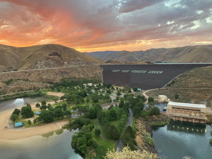
Lucky Peak Dam was authorized in 1946 to provide flood risk management, irrigation storage, recreation, and environmental stewardship. The dam holds back reservoir of approximately 265,000 acre-feet of water extending fifteen miles upstream (about a quarter of the 1M acre feet stored by the three-dam system on the Boise River comprised of Lucky Peak, Arrowrock, and Anderson Ranch). In 1984, the irrigator-owned Lucky Peak Power Plant Project was authorized, beginning construction of a 101MW hydropower facility that completed in 1988. Today, Lucky Peak Lake hosts about 900,00 recreational visits annually, provides invaluable wintering range for mule deer and elk, and reduces the risk of flood in the Treasure Valley.
This tour for family groups and individuals will provide an overview of the construction of Lucky Peak Dam, current operations of the dam, relationships with many partners including the Lucky Peak Power Plant Project (non-Corps), and big picture water management considerations of the Upper Boise Basin.
For larger tour groups, please make special arrangements by reaching out to the Lucky Peak Lake Office at (208) 343-0671 or emailing luckypeaklake@usace.army.mil .
Getting there
From Gowen Road (Exit 57) off I-84, head east toward South Federal Way and follow Highway 21 towards Idaho City for 11.5 miles before turning right onto Lucky Peak Dam (bearing the large, iconic message “Keep Your Forests Green” upon it). As the Intake Tower and Service Bridge draw near, please park perpendicularly in the cross-hatched area signed “No Stopping Any Time” (tour guests may violate this parking policy). Here you will be met by a park ranger 15 minutes before the event.
There is no address for this location – please refer to Lat/Lon coordinates provided and the link for driving directions in the Facility Need to Know section.
43.52631, -116.05623 · 43°31'34.7"N 116°3'22.4"W
Typical weather
Typically 93°F in Jul, down to 40°F in Dec.
| Jan | Feb | Mar | Apr | May | Jun | Jul | Aug | Sep | Oct | Nov | Dec | |
|---|---|---|---|---|---|---|---|---|---|---|---|---|
| High °F | 40 | 46 | 56 | 63 | 74 | 82 | 93 | 91 | 81 | 67 | 50 | 40 |
| Low °F | 26 | 27 | 33 | 37 | 45 | 51 | 59 | 58 | 50 | 41 | 32 | 25 |
| Precip in | 2.0 | 1.2 | 1.6 | 1.5 | 1.9 | 1.1 | 0.3 | 0.3 | 0.5 | 1.0 | 1.4 | 2.3 |
1991–2020 averages from the nearest NOAA station, 0.1 mi away — not measured at the facility itself, and elevation can make a real difference over that distance.
Map
More photos

Member photos
Common questions about Lucky Peak Lake Tours and Programs
- Can you reserve a site at Lucky Peak Lake Tours and Programs?
- Yes, Lucky Peak Lake Tours and Programs is reservable through Recreation.gov.
Camping near Lucky Peak Lake Tours and Programs
- Robie Creek Park Group Shelter 7.8 mi · Campground · we watch it
- Macks Creek Campground 8.3 mi · Campground · we watch it
- Shafer Butte 17.8 mi · Campground · we watch it
- Three Point Mountain Trailhead 7 mi · Facility
- Bender Creek Trailhead 9.4 mi · Facility
- Lower Hull's Gulch Trailhead 9.6 mi · Facility
- 8th Street Trailhead 9.7 mi · Facility
- Hulls Gulch Interpretive Trail 10.4 mi · Facility
- Miller Gulch Trailhead 11.9 mi · Facility
- Willow Creek Trailhead (Mountain Home) 12.3 mi · Facility
- Cottonwood Campground 13.7 mi · Campground
- Willow Creek Campground (Mountain Home) 17.2 mi · Campground
Contact
- Phone 208-343-0671
- Email LuckyPeakLake@usace.army.mil
- Book Recreation.gov
Recreation.gov last updated this record on 2026-02-25.
Facility information and photographs from Recreation.gov (RIDB). SpotOpened is not affiliated with Recreation.gov or any federal agency.
Comments