Castle Butte Lookout
Campground · Idaho · 1 bookable site ·
Managed by the USDA Forest Service
North Lochsa Slope Roadless Area (Idaho Roadless Rule (2008)) · Open Access
- 1
- Bookable site
- up to 4
- People per site
- 6,594 ft
- Elevation
Overview
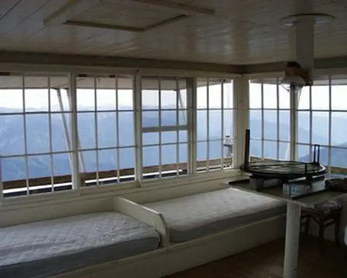
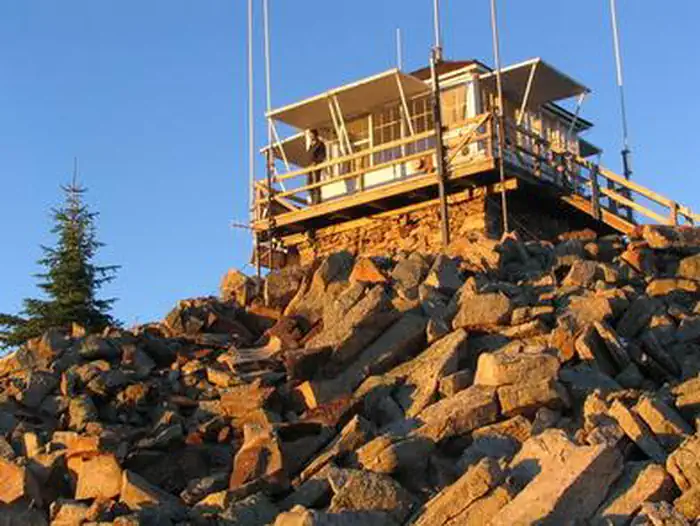
Castle Butte Lookout is a unique cabin perched on a rocky point, 6,659 feet above sea level. It offers breathtaking, 360-degree views of the Selway-Bitterroot Wilderness, the Seven Devils Mountains, the Great Burn area and the deep canyons of the North Fork Clearwater River's upper drainages.A cabin was first constructed on this site in 1916 and was replaced in 1928 with a log cabin featuring a cupola. The current lookout was built in 1950.
Access to the lookout is via the Lolo Motorway, a primitive, single-lane road constructed by the Civilian Conservation Corps in the early 1930s. It is not recommended for large RVs, vehicles with low ground clearance or trailers. Guests should be prepared to walk about 100 feet up steep, rocky terrain to reach the lookout.
Castle Butte Lookout is equipped with a few creature comforts, but guests will need to bring some gear and supplies to help make their stay enjoyable. The panoramic view guarantees a memorable stay.
Recreation
Hikers can follow the paths of the Nez Perce and Lewis and Clark on the historic Lolo Trail. The Lolo Motorway is popular with off-road vehicle enthusiasts. Click here for an Idaho OHV safety message.Huckleberries are abundant in the summer, offering good berry picking opportunities.
Facilities
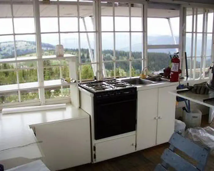
Castle Butte Lookout can accommodate four people and comes equipped with two twin beds with foam mattresses, two cots, a table with two chairs, mop & bucket, a propane cook stove, propane lights, propane heater and propane. A pit toilet is located in a separate building outside. Click here for additional cabin details. The cabin does not have electricity or water. Guests should bring their own water supply as there is no close water source. Guests must provide their own emergency lighting, garbage bags, bedding, matches, toilet paper, cookware and cooking utensils. The cabin should be cleaned before departure.Natural Features
The lookout is surrounded by a rocky landscape that quickly gives way to dense forests of lodgepole and ponderosa pines.This unique facility offers an ideal vantage point to watch sunrises and sunsets, and gaze at the stars. Wildlife enthusiasts may spot eagles, bears, moose, elk, deer and mountain goats.
Contact Info
For facility specific information, please call (208) 942-0313.Nearby Attractions
The Lolo Motorway stretches for 100 miles through scenic mountain landscapes. Summer visitors can see meadows and hillsides blanketed in colorful wildflowers. Travelers should be prepared for rough, sometimes treacherous conditions. No services are located along this road, so travelers should have plenty of gas, food and water for the drive.The facts
- 1 bookable site
- Up to 4 people per site
- Loops: AREA CASTLE BUTTE LOOKOUT
Site types
- 1 Cabin Nonelectric
Amenities
- Shade
- Pets allowed
Not recorded upstream: electric hookups, water hookups, sewer hookups, campfires allowed, fire pits, picnic tables, grills.
1 campsite at Castle Butte Lookout
Check-in 2:00 PM · Check-out 2:00 PM
| Site | Loop | Type | Entry | Surface | Max rig | People | |
|---|---|---|---|---|---|---|---|
| 001 | AREA CASTLE BUTTE LOOKOUT | Cabin Nonelectric | — | Gravel | — | 4 | 🐾 |
Getting there
From Missoula, MT: Take US Highway 12 West for about approximately 78 miles (milepaost 139.7) to Forest Service Road #107 . All roads from this point are gravel or dirt and a vehicle with high clearance is suggested. Turn right onto Forest Service Road #107 (Saddle Camp and Gravey Creek), and go approx. 8 miles. Turn left at the first left in the intersection onto Forest Service Road #500 (Lolo Motorway), To confirm on correct road there will be interpretive signs on the right in roughly 75 feet. Continue west approximately 9.5 miles. This stretch of the road is windy and narrow. Turn left onto Forest Service Road #561 (Castle Butte Rd). It will be signed. This stretch of the road is very rough, rocky and bumpy, high clearance is advised. Travel south about 1.5 miles to the Castle Butte Lookout. Estimated driving time from Missoula is 3 hours.
From Kooskia, ID: Take US Highway 12 East for approximately 17 miles and turn left onto Forest Service Road 101 (Smith Creek Rd). All roads from this point are gravel or dirt and a vehicle with high clearance is suggested. Travel approximately 21 miles, then take a slight right onto Forest Service Road 500 (Lolo Motorway) at the Mex Mountain junction. Travel approximately 33 miles, turn right onto Forest Service Road 561. Turn right onto Forest Service Road #561 (Castle Butte Rd) and travel south about 1.5 miles to the Castle Butte Lookout. Estimated driving time from Kooskia is 5 hours. From Kamiah, ID: Take US Highway 12 East for about 1 mile and turn left at the end of the bridge over the Clearwater River onto Woodland Road. Drive about 1 mile and turn right onto Glenwood Road (Forest Service Road 100). Drive for about 23 miles to Road 103 at the Musselshell junction. All roads from this point are gravel or dirt and a vehcile with high clearance is suggested. Turn right onto Forest Service Road 103 (Gravey Creek Road) and travel 11 miles to Beaver Dam Saddle. Turn right onto Forest Service Road 104, travel for 1 mile. Take a left onto Road 500 (Lolo Motorway) travel approximately 20 miles to Forest Service Road 561 (Castle Butte Road). Turn right onto Forest Service Road #561 (Castle Butte Rd) and travel south about 1.5 miles to the Castle Butte Lookout. Estimated driving time from Kamiah is 4 hours.
46.43417, -115.21917 · 46°26'3.0"N 115°13'9.0"W
Typical weather
| Jan | Feb | Mar | Apr | May | Jun | Jul | Aug | Sep | Oct | Nov | Dec | |
|---|---|---|---|---|---|---|---|---|---|---|---|---|
| High °F | — | — | — | — | — | — | — | — | — | — | — | — |
| Low °F | — | — | — | — | — | — | — | — | — | — | — | — |
| Precip in | 9.9 | 7.7 | 7.9 | 6.3 | 5.0 | 4.4 | 1.4 | 1.6 | 2.7 | 6.1 | 9.4 | 9.6 |
1991–2020 averages from the nearest NOAA station, 9.3 mi away — not measured at the facility itself, and elevation can make a real difference over that distance.
Map
More photos
Member photos
Common questions about Castle Butte Lookout
- Can you reserve a site at Castle Butte Lookout?
- Yes, Castle Butte Lookout is reservable through Recreation.gov.
- How many campsites does Castle Butte Lookout have?
- 1 site.
- Are pets allowed at Castle Butte Lookout?
- Yes, pets are allowed at Castle Butte Lookout.
Camping near Castle Butte Lookout
- Liz Creek Cabin 4.6 mi · Campground · we watch it
- Wilderness Gateway 7.7 mi · Campground · we watch it
- Scurvy Mountain Lookout 18.1 mi · Campground · we watch it
- Eagle Mountain Trailhead 4.3 mi · Facility
- Mocus Point Trailhead 9.8 mi · Facility
- Warm Springs Trailhead 16.1 mi · Facility
- Split Creek Trailhead and River Access 16.5 mi · Facility
- Weitas Creek Campground 17.3 mi · Campground
- Fourth Of July Trailhead 17.6 mi · Facility
- Scurvy Mountain Lookout 18.1 mi · Facility
- Knife Edge Campground and River Access 18.7 mi · Campground
- Noe Creek Campground 18.7 mi · Campground
Contact
- Phone 208-926-4258
- Book Recreation.gov
Recreation.gov last updated this record on 2026-07-25.
Facility information and photographs from Recreation.gov (RIDB). SpotOpened is not affiliated with Recreation.gov or any federal agency.
Comments