State Bridge Recreation Site
Facility · Colorado ·
Managed by the Bureau of Land Management
Colorado River Segment 6 (Eligible - Recreational) · Open Access
- 6,789 ft
- Elevation
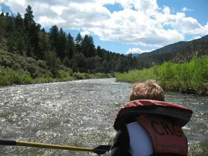
State Bridge is a river access and parking site along the Upper Colorado River. The river segment between Pumphouse and State Bridge has heavy public use. Below State Bridge, fewer boaters are seen. Site features include one paved boat launch and an unpaved small-craft launch, toilets, dressing rooms, garbage service and non-potable water.
The original State Bridge over the Colorado River was built in 1860, and was one of the oldest vehicular bridges in Colorado. It was pivotal in the development of North Park and the Yampa Valley regions of northwest Colorado. The bridge was replaced with a modern bridge in 1966. Portions of the old bridge can be seen in the middle of the river and on the north bank. For more information, please contact the Kremmling Field Office.
The original State Bridge over the Colorado River was built in 1860, and was one of the oldest vehicular bridges in Colorado. It was pivotal in the development of North Park and the Yampa Valley regions of northwest Colorado. The bridge was replaced with a modern bridge in 1966. Portions of the old bridge can be seen in the middle of the river and on the north bank. For more information, please contact the Kremmling Field Office.
Getting there
State Bridge is located on the Upper Colorado River along the Colorado River Headwaters Scenic Byway between Bond and Kremmling and 14 mile from Highway I-70 and the Wolcott exit. Easily accessible From I-70 at Wolcott (Exit #157), State Bridge is only a 40 minute drive from Vail and 1 hour from Steamboat Springs and Winter Park.
FROM DENVER OR WEST COLORADO - Take I-70 to Exit #157 at Wolcott. Follow signs toward Steamboat Springs, Highway 131 north. In 14.4 miles, you cross the Colorado River, and you're looking at State Bridge. Take a right just after the bridge onto Trough Road and you're there.
FROM ESTES PARK - Take US-34 West to Granby. Take US-40 West to Kremmling. Turn left on CO-9 South for about 2 miles. After crossing the river, turn right (West) on the Colorado River Headwaters Scenic Byway (Grand County Rt #1) and follow the river for 19 miles. Rancho Del Rio is on the right.
FROM ESTES PARK - Take US-34 West through Granby to Kremmling. Turn left on CO-9 South for about 2 miles. After crossing the river, turn right (West) on the Colorado River Headwaters Scenic Byway (Grand County Rt #1), also known as Trough Road, and follow the river for about 22 miles to State Bridge.
FROM DENVER OR WEST COLORADO - Take I-70 to Exit #157 at Wolcott. Follow signs toward Steamboat Springs, Highway 131 north. In 14.4 miles, you cross the Colorado River, and you're looking at State Bridge. Take a right just after the bridge onto Trough Road and you're there.
FROM ESTES PARK - Take US-34 West to Granby. Take US-40 West to Kremmling. Turn left on CO-9 South for about 2 miles. After crossing the river, turn right (West) on the Colorado River Headwaters Scenic Byway (Grand County Rt #1) and follow the river for 19 miles. Rancho Del Rio is on the right.
FROM ESTES PARK - Take US-34 West through Granby to Kremmling. Turn left on CO-9 South for about 2 miles. After crossing the river, turn right (West) on the Colorado River Headwaters Scenic Byway (Grand County Rt #1), also known as Trough Road, and follow the river for about 22 miles to State Bridge.
39.85678, -106.64854 · 39°51'24.4"N 106°38'54.7"W
Typical weather
| Jan | Feb | Mar | Apr | May | Jun | Jul | Aug | Sep | Oct | Nov | Dec | |
|---|---|---|---|---|---|---|---|---|---|---|---|---|
| High °F | — | — | — | — | — | — | — | — | — | — | — | — |
| Low °F | — | — | — | — | — | — | — | — | — | — | — | — |
| Precip in | 1.1 | 1.1 | 1.2 | 1.9 | 1.7 | 1.1 | 1.7 | 1.6 | 1.7 | 1.4 | 1.1 | 1.1 |
1991–2020 averages from the nearest NOAA station, 8.7 mi away — not measured at the facility itself, and elevation can make a real difference over that distance.
Map
Fees and stay limits
$5/vehicle per day. Fee applies at Pumphouse, Radium and State Bridge.
Stay limit: Day Use Only
From Recreation.gov, which is not always current. The operator's own page is the authority on what you will be charged.
Member photos
Common questions about State Bridge Recreation Site
- Can you reserve a site at State Bridge Recreation Site?
- No. State Bridge Recreation Site is not reservable through Recreation.gov, so sites are first-come, first-served or booked elsewhere.
- How long can you stay at State Bridge Recreation Site?
- Day Use Only
Camping near State Bridge Recreation Site
- Radium Recreation Area 8.2 mi · Campground · we watch it
- Piney Guard Station 8.3 mi · Campground · we watch it
- Pumphouse Recreation Area 11.7 mi · Campground · we watch it
- Windy Point Site less than 0.1 mi · Facility
- Bocco Mountain Trailhead 8.4 mi · Facility
- Stiffel Creek Trailhead 9.2 mi · Facility
- Catamount Bridge Boat Launch 10 mi · Facility
- Wolcott Campground 10.3 mi · Campground
- Elliot's Ridge #1889 12.1 mi · Facility
- Meadow Creek #1891 13.3 mi · Facility
- King Mountain Trailhead 131 14 mi · Facility
- Blacktail Creek Campground 15 mi · Campground
Contact
- Phone 970-724-3000
- Email kfo_webmail.@blm.gov
- Info Recreation.gov
Recreation.gov last updated this record on 2026-02-25.
Facility information and photographs from Recreation.gov (RIDB). SpotOpened is not affiliated with Recreation.gov or any federal agency.
Comments