Radium Recreation Area
Campground · Colorado · 21 bookable sites ·
Managed by the Bureau of Land Management
Kremmling Field Office (Bureau of Land Management CO) · Open Access
- 21
- Bookable sites
- 18 ft
- Max rig length
- up to 30
- People per site
- 1
- Accessible site
- 6,873 ft
- Elevation

Overview
Managed By Kremmling Field Office
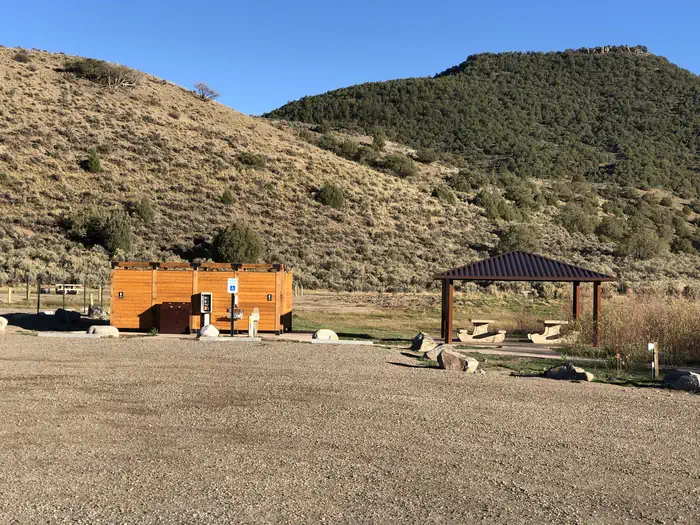
The Radium Recreation Area is part of the Upper Colorado River Special Recreation Management Area (SRMA), providing opportunities for developed camping and river access. With over 100,000 annual visitors the sites facilities include 2 developed boat ramp sites, 9 vault toilets, day use and overnight parking, 16 single campsites and 2 Group Campsites and 3 day use shade structures. There is no potable water provided at this area. The area is used by visitors to access the river for floatboating and fishing opportunities.
Recreation
Recreation opportunities include river access for fishing and floatboating. On-site picnic shelters provide visitors with opportunities to a covered area for relaxing and picnicking.
Note – Radium Warm Springs Access:
There are no designated trails from this area and there is no designated access to the Radium Warm Springs. Parking is not permitted along the narrow Radium Road between the Radium Recreation Area and Trough Road to ensure safe passage of vehicles and ensure clear passage for Emergency Vehicles when needed. Please respect the social trail closures and restoration conducted on BLM managed lands along Radium Road that protect area wildlife habitat including area Big Horn Sheep.
The Colorado Parks and Wildlife Mugrage Site along Radium Road, including the restroom and social trail that accessed the Radium Warm Springs within the Radium State Wildlife Area, is closed for the protection of this important habitat.
The BLM is looking at a potential future designated and developed trail from the Radium Recreation Area.
Until a trail alignment along Radium Road is developed it is recommended that the easiest and safest way to access the Radium Warm Springs from Radium Recreation Area is to drive to Warm Springs Road 1.5 northeast along Trough Road. Follow the directional sign located at the intersection of Radium Road and Trough Road. A parking area and trailhead at the end of Warm Springs Road provides access to the Radium Warm Springs via the Warm Springs Trail open to foot travel only, or the Ol’ Warm Springs Trail which is open to Foot, Horse, Bicycle and eBike travel.
Facilities
Each campsite must be reserved through Recreation.gov and has varying space for parking (see parking size limitations before completing your reservation), a picnic table, a fire ring, and close proximity to a vault toilet and trash receptacles. Campsites 1-4 are walk-in sites and have parking for one vehicle without a trailer. Campsites 5-13 have pull through parking areas and can typically fit one to two vehicles and small trailers. Campsites 14-16 have pull in parking and is 30 feet in length or less. Additional vehicles not fitting within a campsite's designated parking must park in the general parking areas.
There are no electric hook-ups and cell service non-existent without a booster.
There are two boat ramps with restrooms.
Natural Features
The Radium Recreation Area is adjacent to the Colorado River next to the small town of Radium. The scenery within the area is a major component to the adjacent Colorado Headwaters National Scenic and Historic Byway and are important features that make this stretch of river Wild and Scenic Eligible.
Nearby Attractions
The town of Kremmling, CO is approximately 20 miles east from Radium Recreation Area where visitors can get supplies.
Rancho Del Rio – a private resort along the Colorado river, has a small store with supplies and is a river access point for those recreating on the river. Rancho Del Rio is located approximately 6 miles west along Trough Road.
Trough Road, which accesses the BLM Recreation Areas and Rancho Del Rio (private river access – fee site) is the Colorado Headwaters National Scenic and Historic Byway. Originating just east of Grand Lake on Highway 34, the byway ends at State Bridge.
The facts
- 21 bookable sites
- 3 sites for day use only
- 1 accessible site
- Vehicles up to 18 ft
- Up to 30 people per site
- Loops: Radium
Site types
- 12 Standard Nonelectric
- 4 Walk To
- 3 Group Shelter Nonelectric
- 2 Group Standard Nonelectric
Amenities
- Campfires allowed
- Pets allowed
- Water hookups — not available
- Shade — not available
Not recorded upstream: electric hookups, sewer hookups, fire pits, picnic tables, grills.
21 campsites at Radium Recreation Area
Check-in 1:00 PM · Check-out 12:00 PM
| Site | Loop | Type | Entry | Surface | Access | Max rig | People | |
|---|---|---|---|---|---|---|---|---|
| 1 - Walk-In Site | Radium | Walk To | Back In | Gravel | Hike In | 18 ft | 10 | 🐾 |
| 10 | Radium | Standard Nonelectric | Pull Through | Gravel | — | — | 10 | 🐾 |
| 11 | Radium | Standard Nonelectric | Pull Through | Gravel | — | — | 10 | 🐾 |
| 12 | Radium | Standard Nonelectric | Pull Through | Gravel | — | — | 10 | 🐾 |
| 13 | Radium | Standard Nonelectric | Pull Through | — | — | — | 10 | 🐾 |
| 14 | Radium | Standard Nonelectric | Back In | — | — | — | 10 | 🐾 |
| 15 | Radium | Standard Nonelectric | Back In | — | — | — | 10 | 🐾 |
| 16 | Radium | Standard Nonelectric | Back In | — | — | — | 10 | ♿ 🐾 |
| 2 - Walk-In Site | Radium | Walk To | Back In | Gravel | Hike In | 18 ft | 10 | 🐾 |
| 3 - Walk-In Site | Radium | Walk To | Back In | Gravel | Hike In | 18 ft | 10 | 🐾 |
| 4 - Walk-In Site | Radium | Walk To | Back In | Gravel | Hike In | 18 ft | 10 | 🐾 |
| 5 | Radium | Standard Nonelectric | Pull Through | Gravel | — | — | 10 | 🐾 |
| 6 | Radium | Standard Nonelectric | Pull Through | Gravel | — | — | 10 | 🐾 |
| 7 | Radium | Standard Nonelectric | Pull Through | Gravel | — | — | 10 | 🐾 |
| 8 | Radium | Standard Nonelectric | Pull Through | Gravel | — | — | 10 | 🐾 |
| 9 | Radium | Standard Nonelectric | Pull Through | Gravel | — | — | 10 | 🐾 |
| Group Site A | Radium | Group Standard Nonelectric | Back In | Gravel | — | — | 30 | 🐾 |
| Group Site B | Radium | Group Standard Nonelectric | Back In | Gravel | — | — | 30 | 🐾 |
| Ramp 1 Day Use Shelter | Radium | Group Shelter Nonelectric | — | — | — | — | 30 | |
| Ramp 2 Day Use Shelter | Radium | Group Shelter Nonelectric | — | — | — | — | 30 | |
| Upper CO Day Use | Radium | Group Shelter Nonelectric | — | — | — | — | 30 |
Getting there
39.95136, -106.55598 · 39°57'4.9"N 106°33'21.5"W
Typical weather
| Jan | Feb | Mar | Apr | May | Jun | Jul | Aug | Sep | Oct | Nov | Dec | |
|---|---|---|---|---|---|---|---|---|---|---|---|---|
| High °F | — | — | — | — | — | — | — | — | — | — | — | — |
| Low °F | — | — | — | — | — | — | — | — | — | — | — | — |
| Precip in | 3.1 | 3.6 | 3.3 | 4.9 | 3.5 | 1.6 | 2.2 | 1.9 | 2.2 | 3.2 | 3.4 | 3.1 |
1991–2020 averages from the nearest NOAA station, 9.6 mi away — not measured at the facility itself, and elevation can make a real difference over that distance.
Map
Fees and stay limits
Fees are required for day use and camping between April 1 - November 30. Campgrounds are closed with no service between December 1 - March 31. • Single Campsites - $6.00 per site - maximum of 10 people and includes 1st vehicle • Group Campsites - $30.00 per site - maximum of 30 people and includes 1st vehicle • Additional Vehicles - $5.00 per day (Including motorcycles and bicycles being used as shuttle vehicles or other offsite recreation) NOTE: Reservations are required for ALL campsites at Radium Recreation Area through Recreation.gov . Campsites become available by 1pm on the 1st day of the reservation. Checkout is 12:00pm. Any vehicle remaining at the Radium Recreation Area after 12:00pm must purchase a day use pass for that day or have a valid federal agency issued season pass for the Upper Colorado River SRMA or a valid America The Beautiful Pass. Colorado State Park passes are NOT valid at this federal fee area.
From Recreation.gov, which is not always current. The operator's own page is the authority on what you will be charged.
More photos

Member photos
Common questions about Radium Recreation Area
- Can you reserve a site at Radium Recreation Area?
- Yes, Radium Recreation Area is reservable through Recreation.gov.
- How many campsites does Radium Recreation Area have?
- 21 sites.
- What is the maximum RV length at Radium Recreation Area?
- 18 ft. That is the longest vehicle the sites here are recorded as taking; individual sites may be shorter.
- Are pets allowed at Radium Recreation Area?
- Yes, pets are allowed at Radium Recreation Area.
- Does Radium Recreation Area have hookups?
- No hookups are recorded here.
- Are campfires allowed at Radium Recreation Area?
- Campfires are allowed at Radium Recreation Area. Check for a current fire restriction before you go.
Camping near Radium Recreation Area
- Pumphouse Recreation Area 3.5 mi · Campground · we watch it
- Blacktail Creek Campground 8.1 mi · Campground
- State Bridge Recreation Site 8.2 mi · Facility
- Windy Point Site 8.2 mi · Facility
- Rock Creek Recreation Area 9.4 mi · Campground
- Elliot's Ridge #1889 10.5 mi · Facility
- Confluence River Access 10.6 mi · Facility
- Kimball Bridge (Highway 9) 11.7 mi · Facility
- Junction Butte Wetlands 11.8 mi · Facility
- Muddy Creek Fishing Access and Kremmling Cliffs 12.2 mi · Facility
- Lynx Pass Campground 12.6 mi · Campground
- King Mountain Trailhead 131 13.2 mi · Facility
Contact
- Phone 970-724-3000
- Email blm_co_kr_webmail@blm.gov
- Book Recreation.gov
Recreation.gov last updated this record on 2026-03-11.
Facility information and photographs from Recreation.gov (RIDB). SpotOpened is not affiliated with Recreation.gov or any federal agency.
Comments