Alpine Ranger Station
Campground · Colorado ·
Managed by the USDA Forest Service
Uncompahgre National Forest (NF) · Open Access
- 0
- Bookable sites
- up to 6
- People per site
- 9,607 ft
- Elevation
Overview
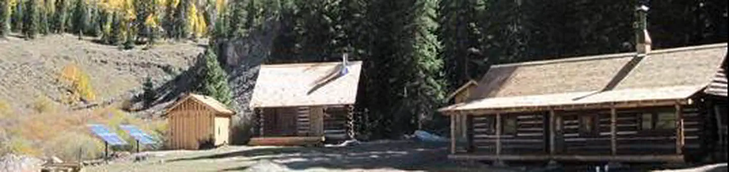
The Alpine Ranger Station is situated on the Alpine Plateau at 9,600 feet, in a beautiful alpine valley surrounded by aspen, spruce and fir forest. With inspiring views and multiple nearby recreation opportunities, the Ranger Station is just the place for a quiet and historic retreat, with a few modern amenities.Recreation
Surrounded by miles of National Forest, visitors to the Alpine Ranger Station can enjoy a multitude of outdoor activities. There are several hiking and mountain biking trails nearby, as well as opportunities for OHV use, including ATV and motorcycle routes. Also, the ranger station has a horse barn and small corral, offering the opportunity for horseback riding. The Uncompahgre Wilderness is adjacent to the Ranger Station and a trailhead to Uncompahgre Peak (a popular 14'er) is only a mile away.Facilities
Visitors can expect to experience two semi-rustic cabins with some modern amenities. The main cabin has a semi-modernized kitchen with a propane cooking stove, refrigerator, and sink. There is a separate bathhouse located a few feet away from the main cabin with a vault toilet. Other amenities include: solar electric lighting and a pot belly wood stove. The main cabin can accommodate up to four people, featuring two bunk beds with four twin-size mattresses. The other cabin has a queen bed on the ground level and a loft.
Basic kitchen supplies - pots/pans/silverware - are provided. Cleaning supplies are provided, and guests are required to clean before they leave. Guests should bring their own bedding and towels.
Plan to pack it in, pack it out. Please take your trash with you when you leave.
Natural Features
The Ranger Station is located near the end of Forest Service Road 868, adjacent to Blue Creek and Soldier Creek. This beautiful area offers many scenic viewing opportunities, including the Cannibal Plateau and the Uncompahgre Wilderness, and is close to many hiking and fishing opportunities.
Nearby Attractions
The small town of Lake City is located about an hour drive from the cabins, it has two small grocery stores, a gas station, and a few restaurants.
The facts
- 0 bookable sites
- 1 site in total, including non-bookable
- Up to 6 people per site
- Loops: ALPINE RANGER STATION
Site types
- 1 Management
Amenities
- Campfires allowed
- Fire pits
- Grills
- Shade
- Pets allowed
Not recorded upstream: electric hookups, water hookups, sewer hookups, picnic tables.
1 campsite at Alpine Ranger Station
Check-in 3:00 PM · Check-out 11:00 AM
| Site | Loop | Type | Entry | Surface | Max rig | People | |
|---|---|---|---|---|---|---|---|
| Cabin | ALPINE RANGER STATION | Management | Back In | Gravel | — | 6 | 🐾 |
Getting there
From Gunnison: Take US-50 west for approximately 35 miles. Turn left on Co. Rd 66 to FSR 867. Follow FSR 867 for approximately 20 miles to its junction with FSR 868. Turn right - Alpine Ranger Station will be 5 miles ahead on the right-hand side, a locked gate is at the entrance. County road 66 and FSR 867 are gravel roads with switchbacks that may be difficult to travel on when they are wet.
From Lake City: From the Lake City Community school travel north on state highway 149 for approximately 11.1 miles. Just after a sign that says "National Forest Access Big Blue" turn left onto Forest Service Road 867 (listed as Alpine Road on Google Maps). Remain on FSR 867 until the junction with FSR 868, from there contiue straight on FSR 868. The cabin will be approximately 5 miles ahead on the right-hand side, a locked gate is at the entrance. County road 66, FSR 867, and FSR 868 are gravel roads with switchbacks that may be difficult to travel on when they are wet.
38.22608, -107.38515 · 38°13'33.9"N 107°23'6.5"W
Typical weather
Typically 77°F in Jul, down to 31°F in Jan.
| Jan | Feb | Mar | Apr | May | Jun | Jul | Aug | Sep | Oct | Nov | Dec | |
|---|---|---|---|---|---|---|---|---|---|---|---|---|
| High °F | 31 | 36 | 43 | 51 | 62 | 74 | 77 | 75 | 68 | 58 | 43 | 31 |
| Low °F | -1 | 4 | 15 | 23 | 30 | 38 | 44 | 43 | 36 | 25 | 13 | 1 |
| Precip in | 1.2 | 1.1 | 1.0 | 1.6 | 1.3 | 0.8 | 2.0 | 2.5 | 1.6 | 1.8 | 1.1 | 1.1 |
1991–2020 averages from the nearest NOAA station, 12.8 mi away — not measured at the facility itself, and elevation can make a real difference over that distance.
Map
More photos


Member photos
Common questions about Alpine Ranger Station
- Can you reserve a site at Alpine Ranger Station?
- Yes, Alpine Ranger Station is reservable through Recreation.gov.
- How many campsites does Alpine Ranger Station have?
- 1 site in total, of which 0 can be booked.
- Are pets allowed at Alpine Ranger Station?
- Yes, pets are allowed at Alpine Ranger Station.
- Are campfires allowed at Alpine Ranger Station?
- Campfires are allowed at Alpine Ranger Station. Check for a current fire restriction before you go.
Camping near Alpine Ranger Station
- Jackson Guard Station 7.5 mi · Campground · we watch it
- Silver Jack Campground (CO) 8.3 mi · Campground · we watch it
- Beaver Lake (CO) 8.7 mi · Campground · we watch it
- Big Cimarron 9 mi · Campground · we watch it
- Curecanti National Recreation Area Tours 15.4 mi · Tickets · we watch it
- Big Blue Campground - Gunnison RD 0.6 mi · Campground
- The Gate Campground 6.9 mi · Campground
- Silver Jack Campground - Ouray RD 8.3 mi · Campground
- Beaver Lake Campground - Ouray RD 8.8 mi · Campground
- Independence Gulch #234 9.9 mi · Facility
- Red Bridge Campground 10.9 mi · Campground
- Gateview Campground 13.4 mi · Facility
Contact
- Phone 970-641-0471
- Book Recreation.gov
Recreation.gov last updated this record on 2026-02-25.
Facility information and photographs from Recreation.gov (RIDB). SpotOpened is not affiliated with Recreation.gov or any federal agency.
Comments