Whitehorse Campground
Campground · California · 19 bookable sites ·
Managed by the USDA Forest Service
Plumas National Forest (NF) · Open Access
- 19
- Bookable sites
- 39 ft
- Max rig length
- up to 8
- People per site
- 5,220 ft
- Elevation
Overview
Whitehorse campground is located within three miles of Bucks Lake in the northern Sierra Mountains on the Plumas National Forest. The Bucks Lake area offers year-round recreation activities including fishing, hiking, snowmobiling, skiing,snowshoeing and horseback riding.Recreation
Staying at the Whitehorse campground provides access to several activites located in the greater Bucks Lake area. Fishing, boating, and canoeing, as well as hiking are all activities that can be achieved by staying in this campground. There are walking trails to the lake. A hiking trail runs from the campground and provides access to the Bucks Lake Wilderness and the Pacific Crest Trail. Marinas and boat docks are also within a short drive as well as restaurants at the Lakeside Resort and Bucks Lake Lodge which will re-open under new management in the summer for 2025, weather permitting. Limited supplies and a deli are located at the Haskins Valley Store just a short drive away.
Facilities
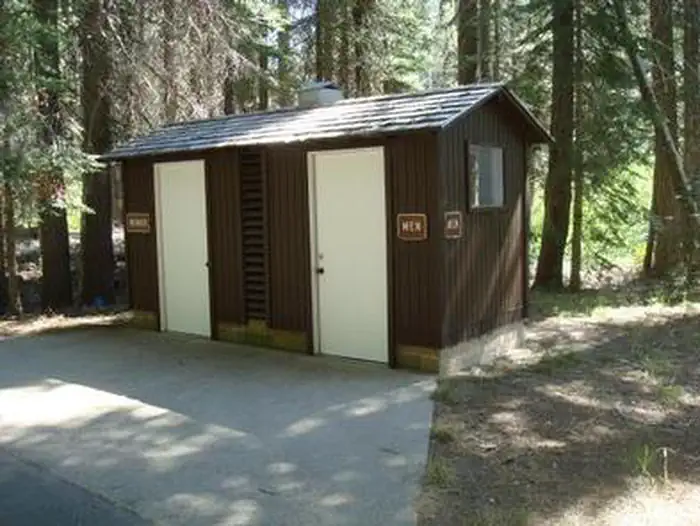
Your camping fees make a difference!!! In 2024 this campground recieved new concrete picnic tables and bear proof food storage lockers in most campsites. Vault toilets, water and trash services are on site as well.
Natural Features
This campground is set in a fir and pine forest offering shade during the warm summer months. Situated at 5,500 feet in elevation, the campground is settled along a small creek that feeds into Bucks Lake.
Nearby Attractions
The nearby Bucks Lake Lodge has a bar, restaurant and store offering fishing supplies and groceries.The facts
- 19 bookable sites
- Vehicles up to 39 ft
- Up to 8 people per site
- Loops: A, B
Site types
- 16 Standard Nonelectric
- 3 Equestrian Nonelectric
Amenities
- Campfires allowed
- Picnic tables
- Pets allowed
- Water hookups — not available
Not recorded upstream: electric hookups, sewer hookups, fire pits, grills, shade.
19 campsites at Whitehorse Campground
Check-in 2:00 PM · Check-out 12:00 PM
| Site | Loop | Type | Entry | Surface | Grade | Max rig | People | |
|---|---|---|---|---|---|---|---|---|
| 01 | A | Standard Nonelectric | Back In | Paved | Slight | — | 8 | 🐾 |
| 02 | A | Standard Nonelectric | Back In | Paved | Slight | 31 ft | 8 | 🐾 |
| 03 | A | Standard Nonelectric | Back In | Paved | Slight | 29 ft | 8 | 🐾 |
| 04 | A | Standard Nonelectric | Back In | Paved | Slight | 36 ft | 8 | 🐾 |
| 05 | A | Standard Nonelectric | Back In | Paved | Slight | 39 ft | 8 | 🐾 |
| 06 | A | Standard Nonelectric | Back In | Paved | Slight | 37 ft | 8 | 🐾 |
| 07 | A | Standard Nonelectric | Back In | Paved | Slight | 36 ft | 8 | 🐾 |
| 08 | B | Standard Nonelectric | Back In | Paved | Slight | — | 8 | 🐾 |
| 09 | B | Standard Nonelectric | Back In | Paved | Slight | — | 8 | 🐾 |
| 10 | B | Standard Nonelectric | Back In | Paved | Slight | — | 8 | 🐾 |
| 11 | B | Standard Nonelectric | Back In | Paved | Slight | — | 8 | 🐾 |
| 12 | B | Standard Nonelectric | Back In | Paved | Slight | — | 8 | 🐾 |
| 13 | B | Standard Nonelectric | Back In | Paved | Slight | — | 8 | 🐾 |
| 14 | B | Standard Nonelectric | Back In | Paved | Slight | — | 8 | 🐾 |
| 15 | B | Standard Nonelectric | Back In | Paved | Slight | — | 8 | 🐾 |
| 16 | B | Equestrian Nonelectric | Back In | Paved | Slight | — | 8 | 🐾 |
| 17 | B | Equestrian Nonelectric | Pull Through | Paved | Slight | — | 8 | 🐾 |
| 18 | B | Equestrian Nonelectric | Back In | Paved | Slight | — | 8 | 🐾 |
| 19 | B | Standard Nonelectric | Back In | Paved | Slight | 20 ft | 8 | 🐾 |
Getting there
Physical Address:
14551 Bucks Lake Road, Bucks Lake, California
From Quincy: Take Oroville-Quincy Hwy west 15 miles to the campground which will be on your left. If you have a large RV you will need to take Oroville-Quincy Hwy, left onto Big Creek Road, right on Bucks Lake Road, and the campground will be on your right.
From Oroville: Take Oroville-Quincy Hwy 162 East. Left on Bucks Lake Road and campground will be on your right.
39.88806, -121.14111 · 39°53'17.0"N 121°8'28.0"W
Typical weather
| Jan | Feb | Mar | Apr | May | Jun | Jul | Aug | Sep | Oct | Nov | Dec | |
|---|---|---|---|---|---|---|---|---|---|---|---|---|
| High °F | — | — | — | — | — | — | — | — | — | — | — | — |
| Low °F | — | — | — | — | — | — | — | — | — | — | — | — |
| Precip in | 11.5 | 10.8 | 10.3 | 5.7 | 3.4 | 1.2 | 0.1 | 0.1 | 0.4 | 2.9 | 6.3 | 12.7 |
1991–2020 averages from the nearest NOAA station, 9.8 mi away — not measured at the facility itself, and elevation can make a real difference over that distance.
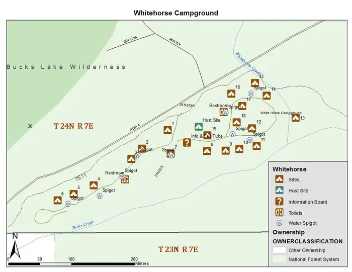
Map
More photos

Member photos
Common questions about Whitehorse Campground
- Can you reserve a site at Whitehorse Campground?
- Yes, Whitehorse Campground is reservable through Recreation.gov.
- How many campsites does Whitehorse Campground have?
- 19 sites.
- What is the maximum RV length at Whitehorse Campground?
- 39 ft. That is the longest vehicle the sites here are recorded as taking; individual sites may be shorter.
- Are pets allowed at Whitehorse Campground?
- Yes, pets are allowed at Whitehorse Campground.
- Does Whitehorse Campground have hookups?
- No hookups are recorded here.
- Are campfires allowed at Whitehorse Campground?
- Campfires are allowed at Whitehorse Campground. Check for a current fire restriction before you go.
Camping near Whitehorse Campground
- Rock Creek Campground (CA) 0.9 mi · Campground · we watch it
- Mill Creek Campground (Plumas) 3.1 mi · Campground · we watch it
- Hutchins 3.1 mi · Campground · we watch it
- Sundew Campground (CA) 3.4 mi · Campground · we watch it
- Grizzly Creek Campground (CA) 3.8 mi · Campground · we watch it
- Silver Lake Campground (Plumas National Forest, CA) 4.9 mi · Campground · we watch it
- Meadow Camp Campground 6 mi · Campground · we watch it
- Deanes Valley Family Cg (CA) Plumas Nf 6.2 mi · Campground · we watch it
- Sandy Point Day Use Area and Boat Launch 2.2 mi · Campground
- Bucks Lake Recreation Area 2.3 mi · Campground
- Hutchins Group Campground 3.3 mi · Campground
- Lower Bucks Campground 3.9 mi · Campground
Contact
- Phone 1-530-283-0555
- Email adam@royalelkparkmanagement.com
- Book Recreation.gov
Recreation.gov last updated this record on 2026-03-11.
Facility information and photographs from Recreation.gov (RIDB). SpotOpened is not affiliated with Recreation.gov or any federal agency.
Comments