Hutchins
Campground · 3 bookable sites ·
Managed by the USDA Forest Service
Plumas National Forest (NF) · Open Access
- 3
- Bookable sites
- 27 ft
- Max rig length
- up to 25
- People per site
- 5,146 ft
- Elevation
Overview
Hutchins Group Campground is the perfect location for groups who want to explore the greater Bucks Lake area of the Plumas National Forest. This campground was severely impacted by the Dixie Fire in 2021. Timber salvage management has left the campground barren and hot so prepare by providing adequate shade for your stay.
American Land & Leisure are the concession operators working for PG&E to service the campgrounds, boat ramps and day use areas that are owned by the USDA Forest Service.
Recreation
The greater Bucks Lake area provides ample opportunities for fishing, boating, and canoeing. The boat ramp at Shady Point provides a boat dock to launch boats, showers, and day use picnicking. Hiking trails are only a short drive away with trailheads located in the Mill Creek Campground, Mill Creek Trailhead on the way to Bucks Summit, and at Bucks Summit where the PCT or Bucks Creek Loop trail are located.
Facilities
THIS CAMPGROUND CURRENTLY HAS NO WATER. Water is available at the nearby Sandy Point Day Use Area and Haskins Campground.
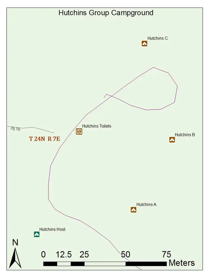
The campground offers three large group campsites for tent and RV camping. Each site has a limit of eight vehicles and 24 people.
Multiple tables and campfire rings with grills are provided, as well as vault toilets . A roving campground host is available intermittently to answer questions and provide additional information.
There are several boat ramps available around the perimeter of the 1,820-acre lake, including the closest one to Hutchins, at Sandy Point. A convenience store with gas, phone and propane is located within five miles of the campground.
Natural Features
At a 5,000-foot elevation, Hutchins campground provides a great jumping off point to explore the greater Bucks Lake area. Hot days, followed by cooler nights, provide the perfect atmosphere for camping. This campground would be a great place for star gazers night owls who really appreciate a wide open sky for night viewing.
Nearby Attractions
The campground is located within walking distance of Bucks Lake. Bucks Lake Wilderness borders the lake and the Pacific Crest National Scenic Trail System traverses the surrounding area. A wilderness permit is not required; however, it is advised that hikers and backpackers leave an itinerary at the trailhead or with campground host.The facts
- 3 bookable sites
- Vehicles up to 27 ft
- Up to 25 people per site
- Loops: HUTC
Site types
- 3 Group Standard Nonelectric
Amenities
- Campfires allowed
- Fire pits
- Picnic tables
- Shade
- Pets allowed
Not recorded upstream: electric hookups, water hookups, sewer hookups, grills.
3 campsites at Hutchins
Check-in 2:00 PM · Check-out 12:00 PM
| Site | Loop | Type | Entry | Surface | Max rig | People | |
|---|---|---|---|---|---|---|---|
| A | HUTC | Group Standard Nonelectric | Back In | Paved | 27 ft | 25 | 🐾 |
| B | HUTC | Group Standard Nonelectric | Back In | Paved | 27 ft | 25 | 🐾 |
| C | HUTC | Group Standard Nonelectric | — | Paved | 27 ft | 25 | 🐾 |
Getting there
39.88306, -121.19917 · 39°52'59.0"N 121°11'57.0"W
Typical weather
| Jan | Feb | Mar | Apr | May | Jun | Jul | Aug | Sep | Oct | Nov | Dec | |
|---|---|---|---|---|---|---|---|---|---|---|---|---|
| High °F | — | — | — | — | — | — | — | — | — | — | — | — |
| Low °F | — | — | — | — | — | — | — | — | — | — | — | — |
| Precip in | 11.5 | 10.8 | 10.3 | 5.7 | 3.4 | 1.2 | 0.1 | 0.1 | 0.4 | 2.9 | 6.3 | 12.7 |
1991–2020 averages from the nearest NOAA station, 7.2 mi away — not measured at the facility itself, and elevation can make a real difference over that distance.
Map
More photos
Member photos
Common questions about Hutchins
- Can you reserve a site at Hutchins?
- Yes, Hutchins is reservable through Recreation.gov.
- How many campsites does Hutchins have?
- 3 sites.
- What is the maximum RV length at Hutchins?
- 27 ft. That is the longest vehicle the sites here are recorded as taking; individual sites may be shorter.
- Are pets allowed at Hutchins?
- Yes, pets are allowed at Hutchins.
- Are campfires allowed at Hutchins?
- Campfires are allowed at Hutchins. Check for a current fire restriction before you go.
Camping near Hutchins
- Grizzly Creek Campground (CA) 1.2 mi · Campground · we watch it
- Sundew Campground (CA) 1.2 mi · Campground · we watch it
- Mill Creek Campground (Plumas) 2.2 mi · Campground · we watch it
- Whitehorse Campground 3.1 mi · Campground · we watch it
- Rock Creek Campground (CA) 3.6 mi · Campground · we watch it
- Silver Lake Campground (Plumas National Forest, CA) 6.2 mi · Campground · we watch it
- Meadow Camp Campground 9 mi · Campground · we watch it
- Bucks Lake Recreation Area 0.9 mi · Campground
- Hutchins Group Campground 1.4 mi · Campground
- Lower Bucks Campground 1.4 mi · Campground
- Sandy Point Day Use Area and Boat Launch 1.7 mi · Campground
- Little North Fork Campground 7.7 mi · Campground
Contact
- Phone 530-283-0555
- Book Recreation.gov
Recreation.gov last updated this record on 2026-03-11.
Facility information and photographs from Recreation.gov (RIDB). SpotOpened is not affiliated with Recreation.gov or any federal agency.
Comments