Santa Barbara Island
Campground · California · 20 bookable sites ·
Managed by the National Park Service
Channel Islands National Park (National Park) · Open Access
- 20
- Bookable sites
- up to 4
- People per site
- 184 ft
- Elevation
Overview
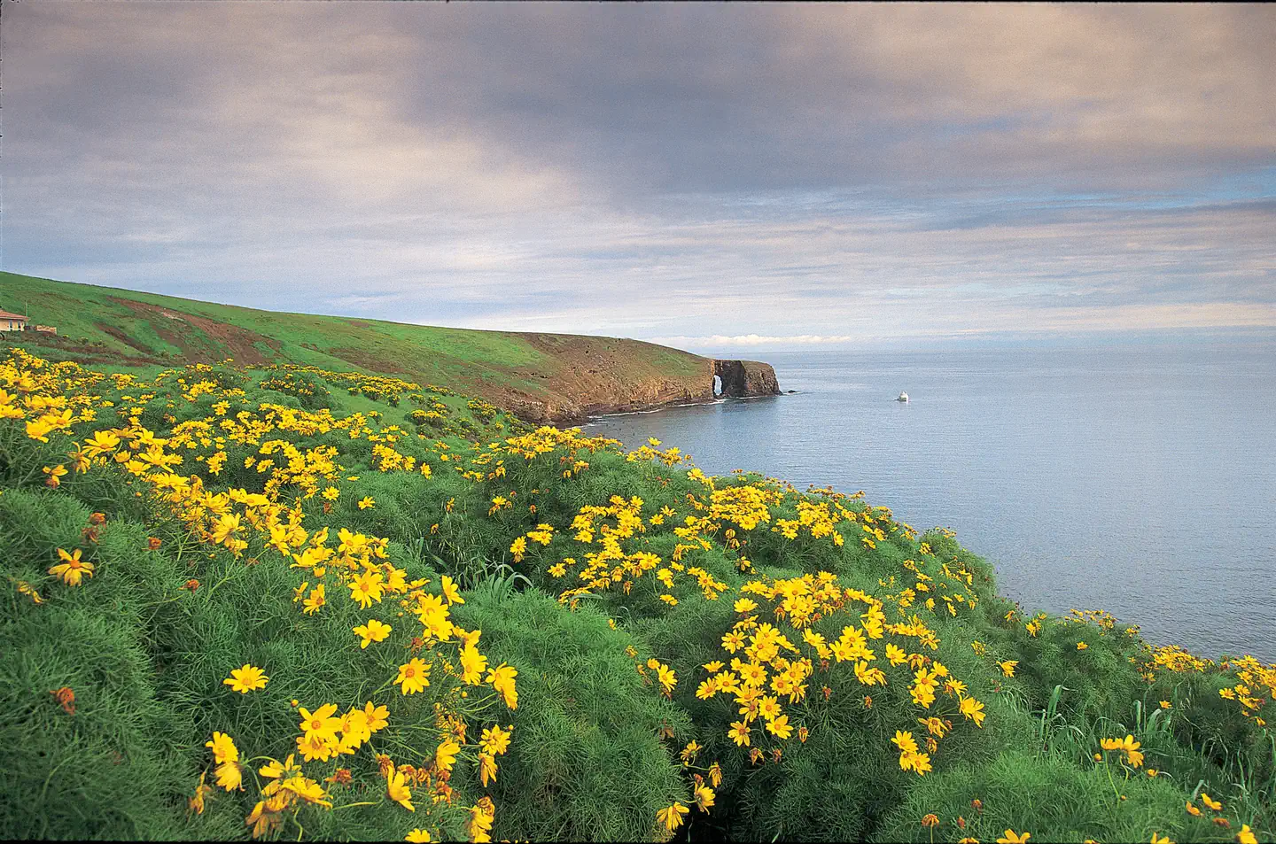
Once visitors have scaled the rugged cliffs using the steep trail from the Landing Cove, they will be rewarded with a campground perched on the bluffs with magnificent coastal views.
Santa Barbara lies much further south than the other four northern Channel Islands and is the smallest, measuring just one square mile. The islands' native vegetation is recovering slowly with the help of the National Park Service's restoration efforts. This recovery, along with the removal of nonnative predators, has aided in the reestablishment of nesting land birds and seabirds. The island is one of the most important seabird nesting sites within the Channel Islands, with 11 nesting species, including western gulls, California brown pelicans, three species of cormorants, three species of storm-petrels, and one of the world's largest colonies of Scripps's murrelets. The rocky shores of Santa Barbara Island also provide resting and breeding areas for California sea lions, harbor seals and northern elephant seals.
Recreation
With five miles of hiking trails, ocean access nearby the campground and generally good weather, Santa Barbara Island offers a variety of recreational activities, including hiking, swimming, snorkeling, diving, kayaking and wildlife/wildflower viewing. Since Santa Barbara Island is a cliff island, access to the water is only at the Landing Cove via a dock. There are no other accessible beaches unless you have a watercraft. There are no services on the island, so all gear has to be brought to the island. For more information about recreational activities in the park, visit https://www.nps.gov/chis/planyourvisit/index.htm.Facilities
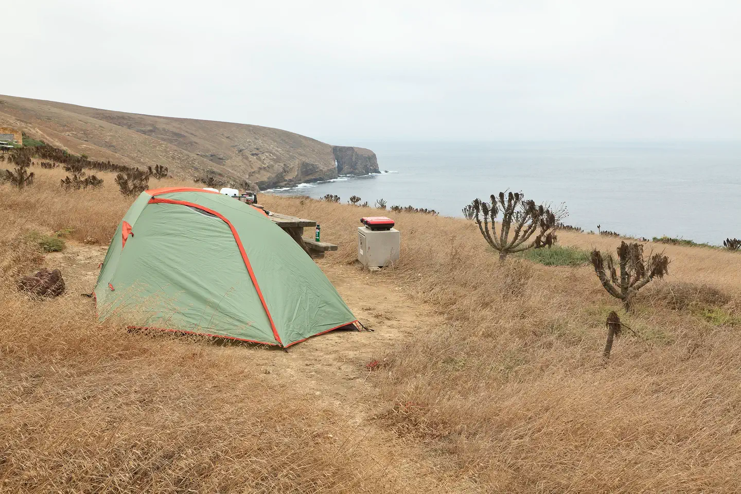
Santa Barbara Island Campground offers 10 campsites (4 persons per site). Camping is primitive and campers must bring their own food, equipment and water. Picnic table, food storage box and pit toilet are provided. Distance from landing to campground is a quarter-mile and includes a 200-foot climb. Access to the island is by Island Packers Cruises or by private boat. Due to the Island Packer boat schedule, minimum stay is generally three days.Natural Features
Steep cliffs on this small island rise above rocky shores and give way to a grassy mesa flanked with twin peaks. The highest point, Signal Peak, is 635 feet in elevation.Nearby Attractions
The Landing Cove near the campground is an ideal place for swimming, diving, snorkeling and kayaking, but there are no lifeguards on the island.
The island is also home to just over five miles of trails that meander over gentle slopes and low mountain tops to dramatic overlooks and magnificent coastal views. All hikers must stay on the trails for visitor safety and to protect fragile vegetation and nesting seabirds. No off-trail hiking is allowed. Portions of trails are subject to closure when pelicans are nesting from January through August.
The facts
- 20 bookable sites
- 21 sites in total, including non-bookable
- Up to 4 people per site
- Loops: SANTA BARBARA ISLAND, SANTA BARBARA ISLAND AREA
Site types
- 20 Tent Only Nonelectric
- 1 Management
Amenities
- Picnic tables
- Campfires allowed — not available
- Pets allowed — not available
Not recorded upstream: electric hookups, water hookups, sewer hookups, fire pits, grills, shade.
21 campsites at Santa Barbara Island
| Site | Loop | Type | Entry | Surface | Access | Water | Max rig | People | |
|---|---|---|---|---|---|---|---|---|---|
| TENT NONELECT | SANTA BARBARA ISLAND | Management | — | — | Hike In | Island | — | 4 | |
| 001 | SANTA BARBARA ISLAND AREA | Tent Only Nonelectric | — | — | Hike In | Island | — | 4 | |
| 001 old | SANTA BARBARA ISLAND AREA | Tent Only Nonelectric | — | — | — | — | — | — | |
| 002 | SANTA BARBARA ISLAND AREA | Tent Only Nonelectric | — | — | Hike In | Island | — | 4 | |
| 002 old | SANTA BARBARA ISLAND AREA | Tent Only Nonelectric | — | — | — | — | — | — | |
| 003 | SANTA BARBARA ISLAND AREA | Tent Only Nonelectric | — | — | Hike In | Island | — | 4 | |
| 003 old | SANTA BARBARA ISLAND AREA | Tent Only Nonelectric | — | — | — | — | — | — | |
| 004 | SANTA BARBARA ISLAND AREA | Tent Only Nonelectric | — | — | Hike In | Island | — | 4 | |
| 004 old | SANTA BARBARA ISLAND AREA | Tent Only Nonelectric | — | — | — | — | — | — | |
| 005 old | SANTA BARBARA ISLAND AREA | Tent Only Nonelectric | — | — | — | — | — | — | |
| 005A | SANTA BARBARA ISLAND AREA | Tent Only Nonelectric | — | — | Hike In | Island | — | 4 | |
| 005B | SANTA BARBARA ISLAND AREA | Tent Only Nonelectric | — | — | Hike In | Island | — | 4 | |
| 006 | SANTA BARBARA ISLAND AREA | Tent Only Nonelectric | — | — | Hike In | Island | — | 4 | |
| 006 old | SANTA BARBARA ISLAND AREA | Tent Only Nonelectric | — | — | — | — | — | — | |
| 007 | SANTA BARBARA ISLAND AREA | Tent Only Nonelectric | — | — | Hike In | Island | — | 4 | |
| 007 old | SANTA BARBARA ISLAND AREA | Tent Only Nonelectric | — | — | — | — | — | — | |
| 008 | SANTA BARBARA ISLAND AREA | Tent Only Nonelectric | — | — | Hike In | Island | — | 4 | |
| 008 old | SANTA BARBARA ISLAND AREA | Tent Only Nonelectric | — | — | — | — | — | — | |
| 009 | SANTA BARBARA ISLAND AREA | Tent Only Nonelectric | — | — | Hike In | Island | — | 4 | |
| 009 old | SANTA BARBARA ISLAND AREA | Tent Only Nonelectric | — | — | — | — | — | — | |
| 010 | SANTA BARBARA ISLAND AREA | Tent Only Nonelectric | — | — | — | — | — | — |
Getting there
To park headquarters in Ventura, California: Highway 101, exit Victoria or Seaward to Ventura Harbor.
33.47985, -119.02989 · 33°28'47.5"N 119°1'47.6"W
Typical weather
Typically 79°F in Aug, down to 60°F in Feb.
| Jan | Feb | Mar | Apr | May | Jun | Jul | Aug | Sep | Oct | Nov | Dec | |
|---|---|---|---|---|---|---|---|---|---|---|---|---|
| High °F | 62 | 60 | 61 | 64 | 67 | 70 | 77 | 79 | 78 | 73 | 67 | 60 |
| Low °F | 50 | 49 | 49 | 50 | 52 | 55 | 59 | 62 | 63 | 58 | 54 | 49 |
| Precip in | 3.0 | 2.8 | 1.7 | 0.8 | 0.4 | 0.2 | 0.1 | 0.0 | 0.1 | 0.5 | 1.0 | 2.2 |
1991–2020 averages from the nearest NOAA station, 35.8 mi away — not measured at the facility itself, and elevation can make a real difference over that distance.
Map
More photos
Member photos
Common questions about Santa Barbara Island
- Can you reserve a site at Santa Barbara Island?
- Yes, Santa Barbara Island is reservable through Recreation.gov.
- How many campsites does Santa Barbara Island have?
- 21 sites in total, of which 20 can be booked.
- Are pets allowed at Santa Barbara Island?
- No, pets are not allowed at Santa Barbara Island.
- Are campfires allowed at Santa Barbara Island?
- Campfires are not allowed at Santa Barbara Island.
Camping near Santa Barbara Island
- Anacapa Island 41.7 mi · Campground · we watch it
- Circle X Ranch Group Campground 43.8 mi · Campground · we watch it
- Santa Cruz Island Scorpion 49.7 mi · Campground · we watch it
- Santa Cruz Island Del Norte Backcountry 51.6 mi · Campground · we watch it
- Visitor Center Anacapa Island 41.7 mi · Visitor Center
- Satwiwa Native American Indian Culture Center 46.5 mi · Facility
- Santa Monica Mountains Anthony C. Beilenson Interagency Visitor Center 46.9 mi · Visitor Center
- Santa Monica Mountains Anthony C. Beilenson Interagency Visitor Center 46.9 mi · Facility
- Prisoners Harbor Campground 52.7 mi · Campground
- Museum of Latin American Art 53 mi · Facility
- Channel Islands National Park Visitor Center 54.8 mi · Facility
- Ronald Reagan Presidential Library and Museum 55.2 mi · Library
Contact
- Phone 805-658-5730
- Book Recreation.gov
Recreation.gov last updated this record on 2026-02-25.
Facility information and photographs from Recreation.gov (RIDB). SpotOpened is not affiliated with Recreation.gov or any federal agency.
Comments