Lava Beds Visitor Center
Facility · California ·
Managed by the National Park Service
Lava Beds National Monument (National Monument) · Open Access
- 4,787 ft
- Elevation
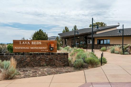
Lava Beds is home to one visitor center located at the south end of the park, near cave loop road. An entrance station is located at the north end of the park, but is only open in the summer. As you drive through the park you can find information kiosks with park maps at Petroglyph Point, and Gillem's Camp.
Getting there
Lava Beds is truly a remote park, in a corner of California most people never visit. Most roads into this area wind through mountains and along rivers, and travel may take longer than expected. Services are few and far between, and winter driving conditions can be encountered any time between fall and spring.
Remember to Plan Ahead - There is no gas available at Lava Beds. We encourage you to top your tank off in one of the nearby communities of Klamath Falls, OR, Merrill, OR, Tulelake, CA, or Alturas, CA.
41.71420, -121.50986 · 41°42'51.1"N 121°30'35.5"W
Typical weather
Typically 86°F in Jul, down to 41°F in Dec.
| Jan | Feb | Mar | Apr | May | Jun | Jul | Aug | Sep | Oct | Nov | Dec | |
|---|---|---|---|---|---|---|---|---|---|---|---|---|
| High °F | 43 | 46 | 52 | 57 | 66 | 76 | 86 | 86 | 78 | 66 | 50 | 41 |
| Low °F | 23 | 25 | 28 | 31 | 38 | 44 | 53 | 51 | 45 | 36 | 27 | 22 |
| Precip in | 1.6 | 2.1 | 1.9 | 1.3 | 1.4 | 1.0 | 0.4 | 0.3 | 0.4 | 0.8 | 1.5 | 1.5 |
1991–2020 averages from the nearest NOAA station, 1 mi away — not measured at the facility itself, and elevation can make a real difference over that distance.
Map
Member photos
Common questions about Lava Beds Visitor Center
- Can you reserve a site at Lava Beds Visitor Center?
- No. Lava Beds Visitor Center is not reservable through Recreation.gov, so sites are first-come, first-served or booked elsewhere.
Camping near Lava Beds Visitor Center
- Lava Beds National Monument Tours 0.1 mi · Tickets · we watch it
- Medicine Lake Recreation Area 9.7 mi · Campground · we watch it
- Little MT. Hoffman Lookout 12.2 mi · Campground · we watch it
- Indian Well Campground 0.4 mi · Campground
- Schonchin Springs Campground 10.1 mi · Campground
- Blanche Lake Campground 11.3 mi · Campground
- Payne Springs Campground 11.3 mi · Campground
- Tule Lake Visitor Center 13.8 mi · Facility
- Harris Spring Campground 22.8 mi · Campground
- Shafter Campground 24.3 mi · Campground
- Orr Lake Campground 25.2 mi · Campground
- Trout Creek Campground 26.9 mi · Campground
Contact
- Phone (530) 667-8113
- Email LABE_Information@nps.gov
- Info Recreation.gov
Recreation.gov last updated this record on 2026-02-25.
Facility information and photographs from Recreation.gov (RIDB). SpotOpened is not affiliated with Recreation.gov or any federal agency.
Comments