Dirt Flat
Campground · California · 7 bookable sites ·
Managed by the USDA Forest Service
Stanislaus National Forest (NF) · Open Access
- 7
- Bookable sites
- up to 6
- People per site
- 1,580 ft
- Elevation
Overview
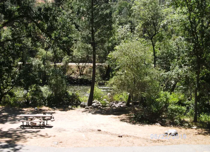
Dirt Flat campground is situated on the north side of the Merced River. This small camp features walk-in tent sites on the river. The remote locates of the site makes for a quiet and peaceful camping experience.Recreation
During the spring and early summer, the Merced River is a popular location for white water rafting and kayaking. Several private companies offer guided rafting trips.Facilities
The campsites at Dirt Flat meet accessibility standards and offer picnic tables, grills and fire rings. Vault toilets are available.Natural Features
The Sierra National Forest, located on the western slope of the central Sierra Nevada, is known for its spectacular mountain scenery and abundant natural resources.The terrain includes rolling, oak-covered foothills, heavily forested middle elevation slopes and the starkly beautiful alpine landscape of the High Sierra.
Nearby Attractions
This campground is close to the west entrance to Yosemite National Park. Yosemite offers a variety of activities that include scenic driving, picnicking, hiking and fishing.Charges & Cancellations
Once your reservation start date has begun, neither the Recreation.gov Contact Center nor the campground manager will be able to modify your reservation.
The facts
- 7 bookable sites
- Up to 6 people per site
- Loops: AREA DIRT FLAT
Site types
- 7 Tent Only Nonelectric
Amenities
- Campfires allowed
- Fire pits
- Pets allowed
Not recorded upstream: electric hookups, water hookups, sewer hookups, picnic tables, grills, shade.
7 campsites at Dirt Flat
Check-in 2:00 PM · Check-out 12:00 PM
| Site | Loop | Type | Entry | Surface | Max rig | People | |
|---|---|---|---|---|---|---|---|
| FT1-20 | AREA DIRT FLAT | Tent Only Nonelectric | Back In | Paved | — | 6 | 🐾 |
| FT1-201 | AREA DIRT FLAT | Tent Only Nonelectric | — | — | — | — | |
| FT1-202 | AREA DIRT FLAT | Tent Only Nonelectric | — | — | — | — | |
| FT1-203 | AREA DIRT FLAT | Tent Only Nonelectric | — | — | — | — | |
| FT1-204 | AREA DIRT FLAT | Tent Only Nonelectric | — | — | — | — | |
| FT1-205 | AREA DIRT FLAT | Tent Only Nonelectric | — | — | — | — | |
| FT1-20N | AREA DIRT FLAT | Tent Only Nonelectric | Back In | Paved | — | 6 | 🐾 |
Getting there
37.66823, -119.83949 · 37°40'5.6"N 119°50'22.2"W
Typical weather
Typically 75°F in Aug, down to 42°F in Feb.
| Jan | Feb | Mar | Apr | May | Jun | Jul | Aug | Sep | Oct | Nov | Dec | |
|---|---|---|---|---|---|---|---|---|---|---|---|---|
| High °F | 44 | 42 | 45 | 49 | 58 | 67 | 75 | 75 | 70 | 60 | 49 | 43 |
| Low °F | 32 | 31 | 32 | 36 | 43 | 52 | 60 | 59 | 54 | 46 | 37 | 32 |
| Precip in | 6.9 | 5.6 | 5.8 | 3.7 | 2.4 | 0.8 | 0.3 | 0.1 | 0.7 | 2.3 | 4.4 | 7.7 |
1991–2020 averages from the nearest NOAA station, 6.4 mi away — not measured at the facility itself, and elevation can make a real difference over that distance.
Map
More photos
Member photos
Common questions about Dirt Flat
- Can you reserve a site at Dirt Flat?
- Yes, Dirt Flat is reservable through Recreation.gov.
- How many campsites does Dirt Flat have?
- 7 sites.
- Are pets allowed at Dirt Flat?
- Yes, pets are allowed at Dirt Flat.
- Are campfires allowed at Dirt Flat?
- Campfires are allowed at Dirt Flat. Check for a current fire restriction before you go.
Camping near Dirt Flat
- Dry Gulch 0.3 mi · Campground · we watch it
- Crane Flat Campground 6.6 mi · Campground · we watch it
- Tamarack Flat Campground 8.1 mi · Campground · we watch it
- Hodgdon Meadow Campground 9.1 mi · Campground · we watch it
- Willow Placer Campground 10.1 mi · Campground · we watch it
- McCabe Flat Campground 10.2 mi · Campground · we watch it
- Briceburg Put-in 8.2 mi · Facility
- Briceburg Visitor Center 8.2 mi · Facility
- Jerseydale Campground 8.5 mi · Campground
- Big Oak Flat Information Station 9.3 mi · Visitor Center
- Cable Rock Day Use Site 9.6 mi · Facility
- Carlon Day Use Area 10.1 mi · Facility
Contact
- Phone 559-642-3212
- Email clm@clm-services.com
- Book Recreation.gov
Recreation.gov last updated this record on 2026-03-11.
Facility information and photographs from Recreation.gov (RIDB). SpotOpened is not affiliated with Recreation.gov or any federal agency.
Comments