Painted Rock Petroglyph Campground
Campground · Arizona · 62 bookable sites ·
Managed by the Bureau of Land Management
Lower Sonoran Field Office (Bureau of Land Management AZ) · Open Access
- 62
- Bookable sites
- up to 37
- People per site
- 3
- Accessible sites
- 586 ft
- Elevation
Overview
Painted Rock Petroglyph Site, approximately 90 miles southwest of Phoenix, Arizona, provides visitors the opportunity to view an archaeological site containing hundreds of figures and designs carved into rocks, known as petroglyphs. These were produced centuries ago by indigenous peoples. This site is considered important and even sacred to many of the Native American tribes in southern Arizona. Please keep this in mind when you visit and be respectful. Climbing on the rocks is prohibited and we ask that you keep dogs out of the area.There are also inscriptions made by people who passed through during historic times.
Many important trails are near the site, some of which have been traveled for thousands of years. The 1775 expedition of Juan Bautista de Anza passed nearby on his way to deliver soldiers, padres, settlers, and their livestock to a new home in northern California to secure the area for Spain. In 1846, the Mormon Battalion passed through, following Philip St. George Cooke along some segments of this trail to help secure California from Mexico. This venture included road building tasks along the trail, assuring that future trips could accommodate wagons. A need to improve communication and travel from east to west prompted Congress to fund a stage line. The result was the Butterfield Overland Stage Route, which began service in 1858 and traveled by this site. This mail and freight service guaranteed that the mail, freight, or passengers would be able to travel from Saint Louis to San Francisco in 25 days. Use was halted when the railroad was constructed in 1879.
Formerly a unit of the Arizona State Park system, jurisdiction of Painted Rock Petroglyph Site returned to the Bureau of Land Management in 1989.
Recreation
The day-use site is right next door to the campground and offers two shaded picnic areas and a small interpretive trail around the petroglyph site with informational displays. The petroglyphs face the east-southeast primarily and would have been noticed by any travelers approaching from that direction. Hiking, birdwatching, and star gazing opportunities all present themselves at this site.
Facilities
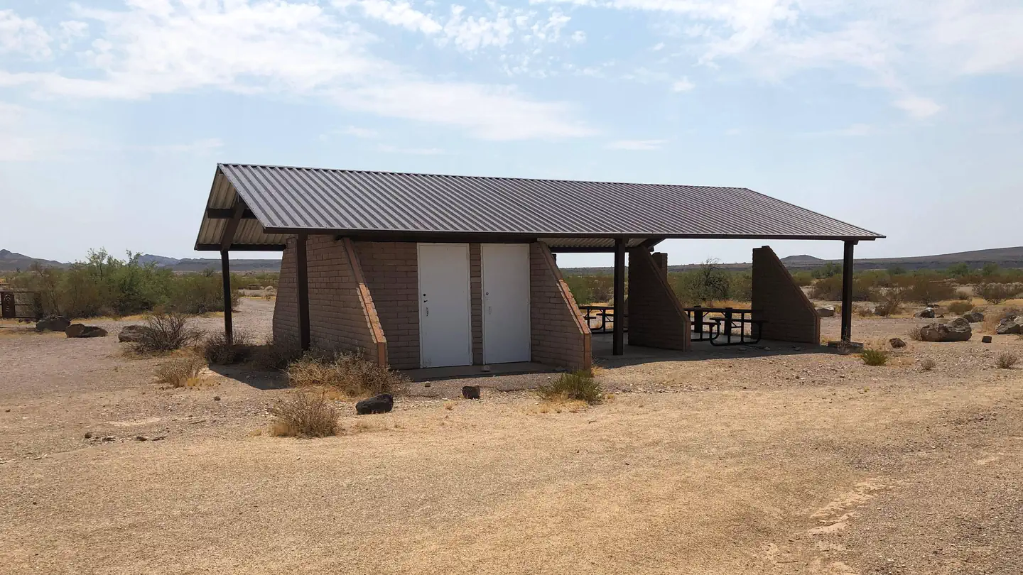
The campground offers visitors 59 individual campsites and two large group sites featuring picnic tables and steel fire rings. There is no water or electric hookups at the campground, but there are two vault toilets and trash collection. The neighboring day-use site has two shaded picnic areas with tables and charcoal grills.
The path to the Painted Rock Petroglyph Campground is on 11 miles of paved roads with an additional 1/2 mile of a dirt road. All roads in the campground and day-use site consist of hardened dirt and gravel suitable for larger RVs (Class A) and trailers (fifth wheels) when road conditions are dry. This area is prone to flash flooding during monsoon season, so be sure to check the weather before planning your visit.
Natural Features
Set between impressive geologic features such as Oatman Mountain, a few miles to the northwest and the Painted Rock Mountains, situated on the eastern horizon, this campground offers scenic panoramic views and plenty of opportunities for solitude and vast night skies. The surrounding area features a diverse Sonoran Desert plant community including the iconic saguaro cactus, various cholla species, barrel cactus, creosote bush, and both ironwood and palo verde trees. The area is home to a large population of desert mule deer and many other desert species such as kit fox, Gambel’s quail, chuckwalla, and desert iguana.
Contact Info
For facility specific information, please call (602) 867-5400.Nearby Attractions
Woolsey Peak Wilderness
Woolsey Peak Wilderness offers rugged topography, colorful scenic vistas, rich variety of wildlife and vegetation, and outstanding opportunities for solitude and unconfined recreation. Woolsey Peak stands 3,270 feet above sea level and about 2,500 feet above the Gila River (to the south). The Painted Rock Dam flood- control dam is situated on the Gila River not far from the southwestern corner of the area. Encompassing a major portion of the Gila Bend Mountains, it is barely separated from the smaller Signal Mountain Wilderness to the north.
Signal Mountain Wilderness
A narrow, four-wheel-drive road is all that separates Signal Mountain Wilderness from Woolsey Peak Wilderness to the south. Signal Mountain itself, rising just north of the center of the area, reaches a summit of 2,182 feet (1,200 feet above the surrounding desert floor).
The facts
- 62 bookable sites
- 64 sites in total, including non-bookable
- 3 accessible sites
- Up to 37 people per site
- Loops: Hohokam Loop, Inner Loop, Main Access Road, Patayan Loop
Site types
- 62 Standard Nonelectric
- 2 Management
Amenities
- Campfires allowed
- Pets allowed
Not recorded upstream: electric hookups, water hookups, sewer hookups, fire pits, picnic tables, grills, shade.
64 campsites at Painted Rock Petroglyph Campground
Check-in 02:00 PM · Check-out 12:00 PM
| Site | Loop | Type | Entry | Surface | Grade | Max rig | People | |
|---|---|---|---|---|---|---|---|---|
| 1 | Hohokam Loop | Standard Nonelectric | Pull Through | Gravel | Slight | — | 10 | ♿ 🐾 |
| 10 | Hohokam Loop | Standard Nonelectric | Pull Through | Gravel | Slight | — | 7 | 🐾 |
| 11 | Hohokam Loop | Standard Nonelectric | Back In | Gravel | Slight | — | 10 | 🐾 |
| 12 | Hohokam Loop | Standard Nonelectric | Pull Through | Gravel | Slight | — | 7 | 🐾 |
| 13 | Hohokam Loop | Standard Nonelectric | Pull Through | Gravel | Slight | — | 7 | 🐾 |
| 14 | Hohokam Loop | Standard Nonelectric | Pull Through | Gravel | Slight | — | 5 | 🐾 |
| 15 | Hohokam Loop | Standard Nonelectric | Pull Through | Gravel | Slight | — | 7 | 🐾 |
| 16 | Hohokam Loop | Standard Nonelectric | Pull Through | Gravel | Slight | — | 5 | 🐾 |
| 17 | Hohokam Loop | Standard Nonelectric | Back In | Gravel | Slight | — | 7 | 🐾 |
| 18 | Hohokam Loop | Standard Nonelectric | Pull Through | Gravel | Slight | — | 7 | 🐾 |
| 19 | Hohokam Loop | Standard Nonelectric | Back In | Gravel | Slight | — | 7 | 🐾 |
| 2 | Hohokam Loop | Standard Nonelectric | Pull Through | Gravel | Slight | — | 5 | ♿ 🐾 |
| 20 | Hohokam Loop | Standard Nonelectric | Pull Through | Gravel | Slight | — | 7 | 🐾 |
| 21 | Hohokam Loop | Standard Nonelectric | Back In | Gravel | Slight | — | 2 | 🐾 |
| 22 | Hohokam Loop | Standard Nonelectric | Pull Through | Gravel | Slight | — | 10 | 🐾 |
| 23 | Hohokam Loop | Standard Nonelectric | Pull Through | Gravel | Slight | — | 7 | 🐾 |
| 24 | Hohokam Loop | Standard Nonelectric | Pull Through | Gravel | Slight | — | 7 | 🐾 |
| 25 | Hohokam Loop | Standard Nonelectric | Pull Through | Gravel | Slight | — | 5 | 🐾 |
| 3 | Hohokam Loop | Standard Nonelectric | Pull Through | Gravel | Slight | — | 7 | 🐾 |
| 4 | Hohokam Loop | Standard Nonelectric | Back In | Gravel | Slight | — | 5 | 🐾 |
| 5 | Hohokam Loop | Standard Nonelectric | Pull Through | Gravel | Slight | — | 7 | 🐾 |
| 6 | Hohokam Loop | Standard Nonelectric | Back In | Gravel | Slight | — | 5 | 🐾 |
| 7 | Hohokam Loop | Standard Nonelectric | Back In | Gravel | Slight | — | 2 | 🐾 |
| 8 | Hohokam Loop | Standard Nonelectric | Back In | Gravel | Slight | — | 2 | 🐾 |
| 9 | Hohokam Loop | Standard Nonelectric | Pull Through | Gravel | Slight | — | 7 | 🐾 |
| Assistant Host Site | Hohokam Loop | Management | — | — | — | — | — | |
| Host Site | Inner Loop | Management | — | — | — | — | — | |
| Group Site A | Main Access Road | Standard Nonelectric | Pull Through | Gravel | Slight | — | 25 | 🐾 |
| Group Site B | Main Access Road | Standard Nonelectric | Pull Through | Gravel | Slight | — | 37 | 🐾 |
| 26 | Patayan Loop | Standard Nonelectric | Back In | Gravel | Slight | — | 5 | 🐾 |
| 27 | Patayan Loop | Standard Nonelectric | Pull Through | Gravel | Slight | — | 7 | 🐾 |
| 28 | Patayan Loop | Standard Nonelectric | Pull Through | Gravel | Slight | — | 7 | 🐾 |
| 29 | Patayan Loop | Standard Nonelectric | Pull Through | Gravel | Slight | — | 10 | 🐾 |
| 30 | Patayan Loop | Standard Nonelectric | Pull Through | Gravel | Slight | — | 7 | 🐾 |
| 31 | Patayan Loop | Standard Nonelectric | Back In | Gravel | Slight | — | 7 | 🐾 |
| 32 | Patayan Loop | Standard Nonelectric | Pull Through | Gravel | Slight | — | 5 | 🐾 |
| 33 | Patayan Loop | Standard Nonelectric | Pull Through | Gravel | Slight | — | 10 | 🐾 |
| 34 | Patayan Loop | Standard Nonelectric | Pull Through | Gravel | Slight | — | 7 | 🐾 |
| 35 | Patayan Loop | Standard Nonelectric | Pull Through | Gravel | Slight | — | 10 | 🐾 |
| 36 | Patayan Loop | Standard Nonelectric | Pull Through | Gravel | Slight | — | 10 | ♿ 🐾 |
| 37 | Patayan Loop | Standard Nonelectric | Pull Through | Gravel | Slight | — | 10 | 🐾 |
| 38 | Patayan Loop | Standard Nonelectric | Pull Through | Gravel | Slight | — | 7 | 🐾 |
| 39 | Patayan Loop | Standard Nonelectric | Pull Through | Gravel | Slight | — | 7 | 🐾 |
| 40 | Patayan Loop | Standard Nonelectric | Pull Through | Gravel | Slight | — | 7 | 🐾 |
| 41 | Patayan Loop | Standard Nonelectric | Pull Through | Gravel | Slight | — | 7 | 🐾 |
| 42 | Patayan Loop | Standard Nonelectric | Pull Through | Gravel | Slight | — | 10 | 🐾 |
| 43 | Patayan Loop | Standard Nonelectric | Pull Through | Gravel | Slight | — | 7 | 🐾 |
| 44 | Patayan Loop | Standard Nonelectric | Pull Through | Gravel | Slight | — | 7 | 🐾 |
| 45 | Patayan Loop | Standard Nonelectric | Pull Through | Gravel | Slight | — | 10 | 🐾 |
| 46 | Patayan Loop | Standard Nonelectric | Pull Through | Gravel | Slight | — | 10 | 🐾 |
| 47 | Patayan Loop | Standard Nonelectric | Pull Through | Gravel | Slight | — | 10 | 🐾 |
| 48 | Patayan Loop | Standard Nonelectric | Pull Through | Gravel | Slight | — | 7 | 🐾 |
| 49 | Patayan Loop | Standard Nonelectric | Pull Through | Gravel | Slight | — | 7 | 🐾 |
| 50 | Patayan Loop | Standard Nonelectric | Back In | Gravel | Slight | — | 7 | 🐾 |
| 51 | Patayan Loop | Standard Nonelectric | Back In | Gravel | Slight | — | 10 | 🐾 |
| 52 | Patayan Loop | Standard Nonelectric | Pull Through | Gravel | Slight | — | 7 | 🐾 |
| 53 | Patayan Loop | Standard Nonelectric | Pull Through | Gravel | Slight | — | 7 | 🐾 |
| 54 | Patayan Loop | Standard Nonelectric | Pull Through | Gravel | Slight | — | 5 | 🐾 |
| 55 | Patayan Loop | Standard Nonelectric | Pull Through | Gravel | Slight | — | 5 | 🐾 |
| 56 | Patayan Loop | Standard Nonelectric | Pull Through | Gravel | Slight | — | 7 | 🐾 |
| 57 | Patayan Loop | Standard Nonelectric | Pull Through | Gravel | Slight | — | 5 | 🐾 |
| 58 | Patayan Loop | Standard Nonelectric | Pull Through | Gravel | Slight | — | 7 | 🐾 |
| 59 | Patayan Loop | Standard Nonelectric | Pull Through | Gravel | Slight | — | 7 | 🐾 |
| 60 | Patayan Loop | Standard Nonelectric | Pull Through | Gravel | Slight | — | 10 | 🐾 |
Getting there
Exit Interstate 8 at Painted Rock Dam Road/Exit 102, about 12.5 miles west of Gila Bend. Travel north on Painted Rocks Dam Road 10.7 miles to Rocky Point Road. Painted Rocks Petroglyph Site is 0.6 miles west of Painted Rock Dam Road on Rocky Point Road.
33.02437, -113.04543 · 33°1'27.7"N 113°2'43.5"W
Typical weather
Typically 108°F in Jul, down to 69°F in Dec.
| Jan | Feb | Mar | Apr | May | Jun | Jul | Aug | Sep | Oct | Nov | Dec | |
|---|---|---|---|---|---|---|---|---|---|---|---|---|
| High °F | 69 | 73 | 80 | 87 | 95 | 105 | 108 | 107 | 102 | 91 | 78 | 69 |
| Low °F | 41 | 45 | 50 | 57 | 64 | 73 | 82 | 81 | 74 | 59 | 47 | 40 |
| Precip in | 0.7 | 0.5 | 0.6 | 0.2 | 0.2 | 0.0 | 0.9 | 0.8 | 0.4 | 0.5 | 0.6 | 0.7 |
1991–2020 averages from the nearest NOAA station, 3.7 mi away — not measured at the facility itself, and elevation can make a real difference over that distance.
Map
Fees and stay limits
The fee for the standard, accessible and group sites is $8.00 per vehicle per night- all sites are first-come, first-serve. This is a Scan and Pay campground. There are no refunds, modifications, cancellations, or other fee changes allowed with Scan and Pay payments. This system is the same as putting cash into a fee tube and cannot be refunded.
From Recreation.gov, which is not always current. The operator's own page is the authority on what you will be charged.
More photos


Member photos
Common questions about Painted Rock Petroglyph Campground
- Can you reserve a site at Painted Rock Petroglyph Campground?
- Yes, Painted Rock Petroglyph Campground is reservable through Recreation.gov.
- How many campsites does Painted Rock Petroglyph Campground have?
- 64 sites in total, of which 62 can be booked.
- Are pets allowed at Painted Rock Petroglyph Campground?
- Yes, pets are allowed at Painted Rock Petroglyph Campground.
- Are campfires allowed at Painted Rock Petroglyph Campground?
- Campfires are allowed at Painted Rock Petroglyph Campground. Check for a current fire restriction before you go.
Also listed by
Painted Rock Petroglyph Campground also appears in other federal recreation data. Facts below are matched by name and location, not confirmed by Painted Rock Petroglyph Campground's operator.
Bureau of Land Management — data as of Aug 24, 2026
- The campground offers visitors 59 individual campsites and two large group sites featuring picnic tables and steel fire rings. There is no water or electric hookups at the campground, but there are two vault toilets and trash collection.
Camping near Painted Rock Petroglyph Campground
- Painted Rock Petroglyph Site and Campground less than 0.1 mi · Campground
- Gila Bend Visitor Center 19.1 mi · Visitor Center
- Margies Cove West Trailhead 27.7 mi · Facility
- Margies Cove West Campground 27.7 mi · Campground
- Brittlebush Trailhead 30.4 mi · Facility
- North Maricopa Mountains Wilderness Area 30.4 mi · Facility
- Margies Cove East Trailhead 33.5 mi · Facility
- South Maricopa Mountains Wilderness Area 38.1 mi · Facility
- Harquahala Byway Staging Area 50.8 mi · Facility
- Box Canyon Recreational Shooting Site 51.8 mi · Facility
- Gunsight Wash 56.9 mi · Facility
- Harquahala Peak Observatory 57.1 mi · Facility
Contact
- Phone (602) 867-5400
- Email blm_az_pdoweb@blm.gov
- Book Recreation.gov
Recreation.gov last updated this record on 2026-03-11.
Facility information and photographs from Recreation.gov (RIDB). SpotOpened is not affiliated with Recreation.gov or any federal agency.
Comments