South Brush Creek Campground (WY)
Campground · Wyoming · 20 bookable sites ·
Managed by the USDA Forest Service
Medicine Bow National Forest (NF) · Open Access
- 20
- Bookable sites
- up to 8
- People per site
- 8,324 ft
- Elevation
Overview
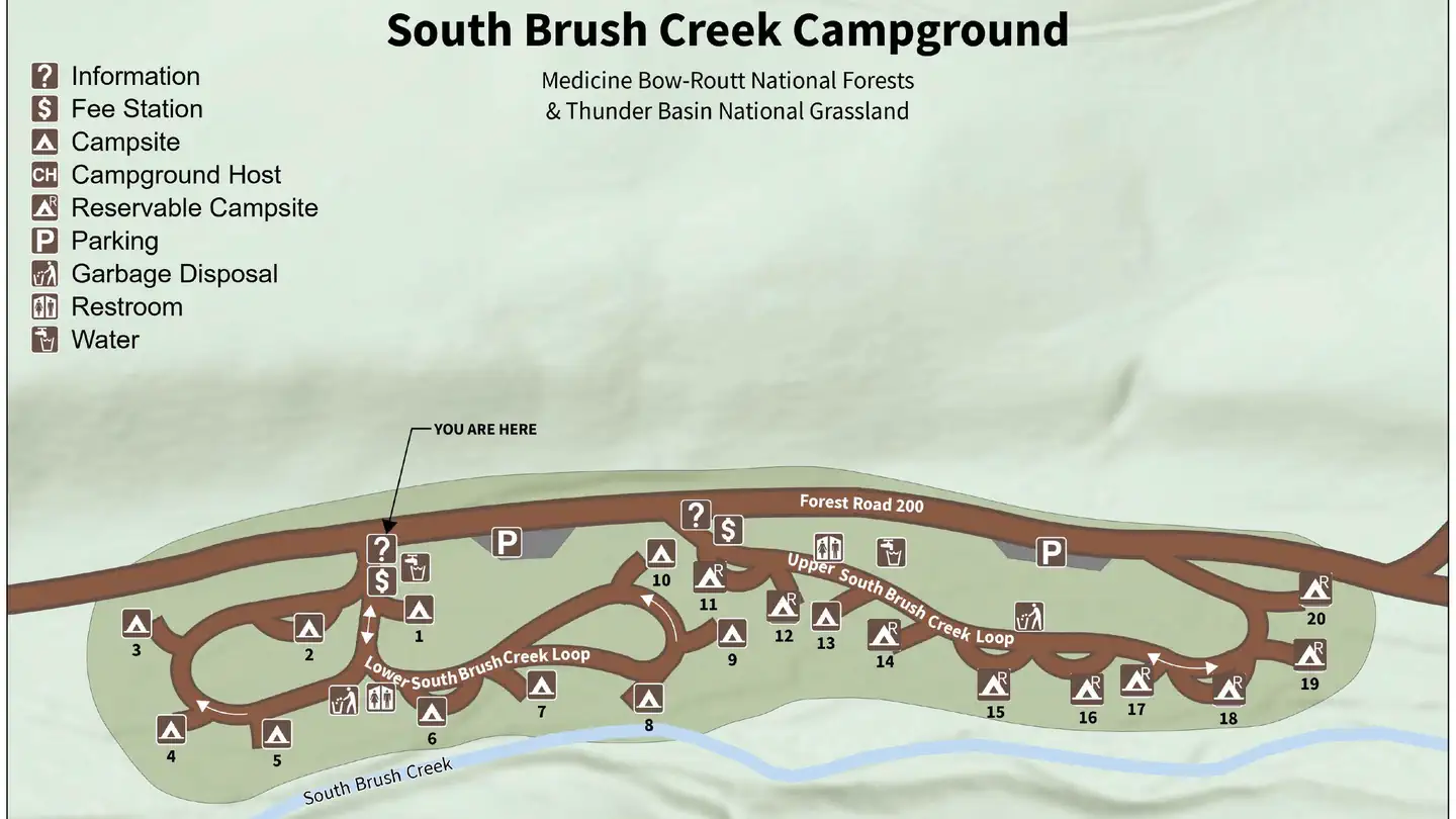
South Brush Creek Campground is located on the west side of the Snowy Range along the shore of South Brush Creek and is a sunny campground composed of two sections located in a dense stand of Lodgepole pines, fir and Aspen trees next to South Brush Creek. The campground has 20 sites, with 6 pull-through sites for trailers under 25 feet. Amenities include picnic tables, fire grates, toilets, trash service, and a camp host on site, and water is available late May through mid September. Pets are allowed but must be kept on a leash no longer than 6 feet and under control at all times. Many hiking, OHV, and fishing opportunities are available in the area
Recreation
The Snowy Range area in the Medicine Bow National Forest is located in southeast Wyoming. The Laramie Ranger District, Brush Creek/Hayden Ranger District, and Parks Ranger District manage portions of the Snowy Range. Year-round recreation uses include hiking, fishing, hunting, snowmobiling, skiing, OHV riding, camping, and biking. Primary access across the Snowy Range is by Highway 130, known as the Snowy Range Scenic Byway.
Mountain Biking
Areas for Mountain Biking at Snowy Range Area
- Bow River Campground
- Deep Creek Campground
- French Creek Campground
- French Creek Canyon Trail
- Keystone Cabins
- Lake Owen Trailhead
- Little Brooklyn Guard Station
- Little Laramie Trailhead
- North Fork Campground
- Pinkham Mountain Trailhead
- Rock Creek Trailhead
- Sheep Lake Trailhead
- Snow Survey Cabin
- Spruce Mountain Fire Lookout
- Tie Hack Lower Trailhead
- Tie Hack Upper Trailhead
- Tipple Trail Trailhead
Mountain Climbing
Areas for Mountain Climbing at Snowy Range Area
- Lewis Lake Picnic Site
- Libby Lake Picnic Site
Day Hiking
Areas for Day Hiking at Snowy Range Area
- Brooklyn Lake Campground
- Brush Creek Trails
- Chimney Park Trailhead
- Corner Mountain Trailhead
- Crater Lake Trailhead
- Deep Creek Campground
- Deep Lake Trail
- Dipper Lake Trail
- French Creek Campground
- French Creek Canyon Trail
- Green Rock Parking Lot
- Green Rock Picnic Site
- Keystone Cabins
- Lake Owen Trailhead
- Lakes Trailhead
- Lewis Lake Picnic Site
- Libby Lake Picnic Site
- Little Brooklyn Guard Station
- Little Laramie Trailhead
- Meadow Falls Trailhead
- Miner's Cabin Trailhead
- North Fork Campground
- Platte River Wilderness
- Quealy Lake Trailhead
- Rock Creek Trailhead
- Routt Access Trailhead
- Ryan Park Campground
- Savage Run Wilderness
- Sheep Lake Trailhead
- Silver Lake Campground
- Silver Lake Trailhead
- Six Mile Trailhead
- Snow Survey Cabin
- South Brush Creek Campground
- Spruce Mountain Fire Lookout
- Sugarloaf Campground
- Tie Hack Lower Trailhead
- Tie Hack Upper Trailhead
- Tipple Trail Trailhead
- West Lake Marie
Backpacking
Areas for Backpacking at Snowy Range Area
- Crater Lake Trailhead
- Deep Lake Trail
- Dipper Lake Trail
- Lakes Trailhead
- Lewis Lake Picnic Site
- Libby Lake Picnic Site
- Platte River Wilderness
- Quealy Lake Trailhead
- Rock Creek Trailhead
- Savage Run Wilderness
- Sheep Lake Trailhead
- Six Mile Trailhead
Viewing Wildlife
Areas for Viewing Wildlife at Snowy Range Area
- Brooklyn Lake Campground
- Keystone Cabins
- Libby Flats Observation Site
- Little Brooklyn Guard Station
- Snow Survey Cabin
- Spruce Mountain Fire Lookout
- Tipple Trail Trailhead
Facilities
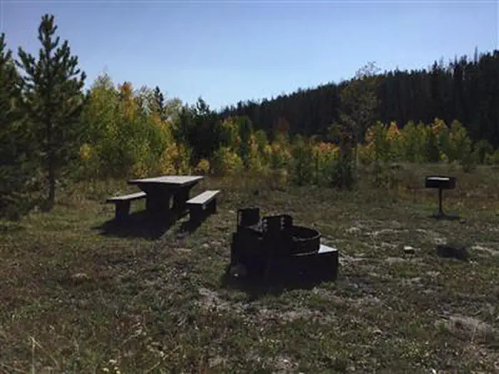
South Brush Creek Campground has sites able to accommodate tents, trailers and RVs. Sites are equipped with picnic tables and campfire rings. The campground also offers vault toilets, trash receptacles, and potable water.
Natural Features
South Brush Creek Campground is situated in a pine, fir and aspen forest forest on the shores of South Brush Creek in the Medicine Bow National Forest in south-central Wyoming. Black bear, bobcat, coyote, elk, mule deer and moose are just some of the many animals that inhabit these rich and diverse lands.
Nearby Attractions
The Snowy Range Scenic Byway is a 29-mile stretch of paved road crosses through spectacular alpine habitats.
The facts
- Season: June – September — USDA Forest Service, Aug 24, 2026
- 20 bookable sites
- Up to 8 people per site
- Loops: South Brush Creek
Site types
- 18 Standard Nonelectric
- 1 RV Nonelectric
- 1 Tent Only Nonelectric
Amenities
- Campfires allowed
- Shade
- Pets allowed
- Water hookups — not available
Not recorded upstream: electric hookups, sewer hookups, fire pits, picnic tables, grills.
20 campsites at South Brush Creek Campground (WY)
Check-in 2:00 PM · Check-out 1:00 PM
| Site | Loop | Type | Entry | Surface | Max rig | People | |
|---|---|---|---|---|---|---|---|
| 001 | South Brush Creek | Standard Nonelectric | Back In | Gravel | — | 8 | 🐾 |
| 002 | South Brush Creek | Standard Nonelectric | Pull Through | Gravel | — | 8 | 🐾 |
| 003 | South Brush Creek | Standard Nonelectric | Back In | — | — | 8 | 🐾 |
| 004 | South Brush Creek | Standard Nonelectric | Back In | — | — | 8 | 🐾 |
| 005 | South Brush Creek | Standard Nonelectric | Back In | — | — | 8 | 🐾 |
| 006 | South Brush Creek | Standard Nonelectric | Pull Through | — | — | 8 | 🐾 |
| 007 | South Brush Creek | Standard Nonelectric | Back In | — | — | 8 | 🐾 |
| 008 | South Brush Creek | Standard Nonelectric | Back In | — | — | 8 | 🐾 |
| 009 | South Brush Creek | Standard Nonelectric | Back In | — | — | 8 | 🐾 |
| 010 | South Brush Creek | Standard Nonelectric | Back In | — | — | 8 | 🐾 |
| 011 | South Brush Creek | Standard Nonelectric | Pull Through | — | — | 8 | 🐾 |
| 012 | South Brush Creek | Standard Nonelectric | Back In | — | — | 8 | 🐾 |
| 013 | South Brush Creek | Rv Nonelectric | Back In | — | — | 8 | 🐾 |
| 014 | South Brush Creek | Standard Nonelectric | Back In | — | — | 8 | 🐾 |
| 015 | South Brush Creek | Standard Nonelectric | Back In | — | — | 8 | 🐾 |
| 016 | South Brush Creek | Standard Nonelectric | Pull Through | — | — | 8 | 🐾 |
| 017 | South Brush Creek | Standard Nonelectric | Back In | — | — | 8 | 🐾 |
| 018 | South Brush Creek | Standard Nonelectric | Pull Through | — | — | 8 | 🐾 |
| 019 | South Brush Creek | Standard Nonelectric | Back In | — | — | 8 | 🐾 |
| 020 | South Brush Creek | Tent Only Nonelectric | Back In | — | — | 8 | 🐾 |
Getting there
Fort Collins, Colorado
Take N Shields St to US-287 N
8 min (3.4 mi)
Head north on S Sherwood St toward W Oak St
0.3 mi
Turn left at the 3rd cross street onto Laporte Ave
0.6 mi
Turn right onto N Shields St
0.5 mi
At the traffic circle, continue straight to stay on N Shields St
2.0 mi
Continue on US-287 N. Take WY-230 W to WY-130 E in Carbon County
2 hr 33 min (158 mi)
Turn left onto US-287 N
0.4 mi
Keep right, follow signs for US-287/Laramie/CO-14/Poudre Cyn
0.5 mi
Continue onto US-287 N
Entering Wyoming
59.2 mi
Slight right to merge onto I-80 W toward Rawlins
1.7 mi
Take exit 311 for WY-130/WY-230 toward Snowy Range Rd
0.3 mi
Turn left onto WY-130 W/WY-230 W/Snowy Range Rd
Pass by McDonald's (on the left in 0.2 mi)
0.8 mi
Continue straight onto W Jackson St
0.4 mi
Continue straight onto WY-230 W
Entering Colorado
39.5 mi
Continue onto CO-127 S
9.1 mi
Turn right onto CO-125 N
Entering Wyoming
8.8 mi
Continue onto WY-230 W
27.0 mi
Turn right to stay on WY-230 W
10.1 mi
Continue on WY-130 E. Drive to S Brush Creek Campground
18 min (13.7 mi)
Turn right onto WY-130 E
12.3 mi
Turn left onto N Brush Creek Rd
0.3 mi
Turn right onto Forest Rd 200
1.1 mi
Turn right onto S Brush Creek Campground
23 ft
South Brush Creek Campground
S Brush Creek Campground, Saratoga, WY 82331
Laramie, Wyoming
Get on I-80 W from S 3rd St and I-80BL W/E Curtis St/Old Stockyard Rd
7 min (2.8 mi)
Head south on S 5th St toward Grand Ave
180 ft
Turn right onto Grand Ave
0.1 mi
Turn right onto S 3rd St
Pass by Subway (on the left)
1.1 mi
Turn left onto I-80BL W/E Curtis St/Old Stockyard Rd
1.2 mi
Turn right to merge onto I-80 W toward Rawlines
0.3 mi
Follow I-80 W to US-287 N/US-30 W/WY-130 E in Walcott. Take exit 235 from I-80 W
1 hr 7 min (74.8 mi)
Merge onto I-80 W
Parts of this road may be closed at certain times or days
74.3 mi
Take exit 235 for US-30 E/US-287 S/WY-130 E toward Walcott/Saratoga
0.4 mi
Follow WY-130 E to S Brush Creek Campground
46 min (41.9 mi)
Turn left onto US-287 N/US-30 W/WY-130 E
Continue to follow WY-130 E
28.2 mi
Turn left to stay on WY-130 E
12.3 mi
Turn left onto N Brush Creek Rd
0.3 mi
Turn right onto Forest Rd 200
1.1 mi
Turn right onto S Brush Creek Campground
23 ft
South Brush Creek Campground
S Brush Creek Campground, Saratoga, WY 82331
Saratoga, Wyoming 82331
Head west on E Bridge Ave toward S 1st St
341 ft
Turn left at the 1st cross street onto WY-130 E/S 1st St
Continue to follow WY-130 E
7.8 mi
Turn left to stay on WY-130 E
12.3 mi
Turn left onto N Brush Creek Rd
0.3 mi
Turn right onto Forest Rd 200
1.1 mi
Turn right onto S Brush Creek Campground
23 ft
South Brush Creek Campground
S Brush Creek Campground, Saratoga, WY 82331
41.34434, -106.50290 · 41°20'39.6"N 106°30'10.4"W
Typical weather
| Jan | Feb | Mar | Apr | May | Jun | Jul | Aug | Sep | Oct | Nov | Dec | |
|---|---|---|---|---|---|---|---|---|---|---|---|---|
| High °F | — | — | — | — | — | — | — | — | — | — | — | — |
| Low °F | — | — | — | — | — | — | — | — | — | — | — | — |
| Precip in | 2.3 | 2.2 | 2.5 | 3.4 | 3.1 | 1.3 | 1.1 | 1.2 | 1.9 | 2.4 | 2.1 | 2.3 |
1991–2020 averages from the nearest NOAA station, 1 mi away — not measured at the facility itself, and elevation can make a real difference over that distance.
Map
Fees and stay limits
$20 night
From Recreation.gov, which is not always current. The operator's own page is the authority on what you will be charged.
More photos
Member photos
Common questions about South Brush Creek Campground (WY)
- Can you reserve a site at South Brush Creek Campground (WY)?
- Yes, South Brush Creek Campground (WY) is reservable through Recreation.gov.
- How many campsites does South Brush Creek Campground (WY) have?
- 20 sites.
- Are pets allowed at South Brush Creek Campground (WY)?
- Yes, pets are allowed at South Brush Creek Campground (WY).
- Does South Brush Creek Campground (WY) have hookups?
- No hookups are recorded here.
- Are campfires allowed at South Brush Creek Campground (WY)?
- Campfires are allowed at South Brush Creek Campground (WY). Check for a current fire restriction before you go.
Also listed by
South Brush Creek Campground (WY) also appears in other federal recreation data. Facts below are matched by name and location, not confirmed by South Brush Creek Campground (WY)'s operator.
USDA Forest Service — data as of Aug 24, 2026
- $20 per site.
Restrictions:
- Maximum trailer length: 25 feet
Camping near South Brush Creek Campground (WY)
- Brush Creek Work Center Barrack 0.9 mi · Campground · we watch it
- Brush Creek Pavilion 1.2 mi · Campground · we watch it
- Ryan Park 1.4 mi · Campground · we watch it
- Snow Survey Cabin 6.6 mi · Campground · we watch it
- Silver Lake Campground (WY) 7.8 mi · Campground · we watch it
- French Creek Campground (WY) 8.2 mi · Campground · we watch it
- Brush Creek Visitor Center 1.1 mi · Facility
- Lincoln Park Campground 2.1 mi · Campground
- Bennett Peak Campground 6.7 mi · Campground
- Bennett Creek Campground 6.8 mi · Campground
- Corral Creek Campground 6.8 mi · Campground
- Quealy Lake Trailhead 8.8 mi · Facility
Contact
- Phone (307) 326-5258
- Book Recreation.gov
Recreation.gov last updated this record on 2026-03-11.
Facility information and photographs from Recreation.gov (RIDB). SpotOpened is not affiliated with Recreation.gov or any federal agency.
Comments