Cottonwood Creek Trailhead
Facility · Wyoming ·
Managed by the Bureau of Land Management
Cody Field Office (Bureau of Land Management WY) · Open Access
- 4,762 ft
- Elevation
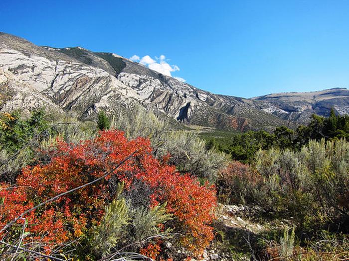
Located near the Cottonwood Canyon Campground and Day-Use site, this highly scenic trail is suitable for hiking and horseback riding (advanced riders). Cottonwood Canyon has steep, vertical cliffs. The elevation at the mouth of the canyon is 4,800 feet with the top of the canyon wall at 7,200 feet. At the upper end of the trail, the elevation at the creek is 7,000 feet and the top of the canyon wall is 7,900 feet.
The trail is about 4 1/2 miles long and winds through BLM-managed public land, Bighorn National Forest land and State of Wyoming land. The trail accesses the Bighorn National Forest where one can continue hiking or horseback riding on primitive roads and trails.
Vegetation in Cottonwood Canyon include narrowleaf cottonwood, willow, waterbirch, red osier dogwood, big sagebrush, juniper, mountain mahogany, Rocky Mountain maple, Indian ricegrass, ninebark, limber pine, Douglas-fir, aspen, and bluebunch wheatgrass.
Things to note: Bring drinking water as Cottonwood Creek disappears underground at times. If using water from the creek, filter it or otherwise treat before drinking.
The trail is about 4 1/2 miles long and winds through BLM-managed public land, Bighorn National Forest land and State of Wyoming land. The trail accesses the Bighorn National Forest where one can continue hiking or horseback riding on primitive roads and trails.
Vegetation in Cottonwood Canyon include narrowleaf cottonwood, willow, waterbirch, red osier dogwood, big sagebrush, juniper, mountain mahogany, Rocky Mountain maple, Indian ricegrass, ninebark, limber pine, Douglas-fir, aspen, and bluebunch wheatgrass.
Things to note: Bring drinking water as Cottonwood Creek disappears underground at times. If using water from the creek, filter it or otherwise treat before drinking.
Getting there
Take Highway 14A until about 10 miles east of Lovell. Immediately on the east side of Bighorn Lake, after the causeway, turn left onto the John Blue Canyon Road (#1122). Take the first road on the right, travel this road for approximately 5 miles until you reach the campground and trailhead.
44.86783, -108.07102 · 44°52'4.2"N 108°4'15.7"W
Typical weather
| Jan | Feb | Mar | Apr | May | Jun | Jul | Aug | Sep | Oct | Nov | Dec | |
|---|---|---|---|---|---|---|---|---|---|---|---|---|
| High °F | — | — | — | — | — | — | — | — | — | — | — | — |
| Low °F | — | — | — | — | — | — | — | — | — | — | — | — |
| Precip in | 2.6 | 2.5 | 2.8 | 3.5 | 3.8 | 3.4 | 1.3 | 1.1 | 2.2 | 2.8 | 2.4 | 2.3 |
1991–2020 averages from the nearest NOAA station, 12.3 mi away — not measured at the facility itself, and elevation can make a real difference over that distance.
Map
Member photos
Common questions about Cottonwood Creek Trailhead
- Can you reserve a site at Cottonwood Creek Trailhead?
- No. Cottonwood Creek Trailhead is not reservable through Recreation.gov, so sites are first-come, first-served or booked elsewhere.
Camping near Cottonwood Creek Trailhead
- Porcupine Campground (Wy) 10.7 mi · Campground · we watch it
- Bald Mountain Campground 11.2 mi · Campground · we watch it
- North Tongue 27 mi · Campground · we watch it
- Cottonwood Creek Campground 0.1 mi · Campground
- Five Springs Falls Campground 6.5 mi · Campground
- Duncom Mountain Burn Observation Site 9.7 mi · Facility
- Horseshoe Bend Campground 11.2 mi · Campground
- Bald Mountain Overlook 12 mi · Facility
- Medicine Creek Campground 18 mi · Campground
- Barry's Landing & Trail Creek Campground 18 mi · Campground
- Big Ice Cave Picnic Area and Interpretive Site 25.9 mi · Facility
- Black Canyon Campground 27 mi · Campground
Contact
- Phone 307-578-5900
- Email cody_wymail@blm.gov
- Info Recreation.gov
Recreation.gov last updated this record on 2026-06-26.
Facility information and photographs from Recreation.gov (RIDB). SpotOpened is not affiliated with Recreation.gov or any federal agency.
Comments