Rock Creek Recreation Site
Facility · Washington ·
Managed by the Bureau of Land Management
Spokane Border Field Office (Bureau of Land Management OR) · Open Access
- 1,462 ft
- Elevation
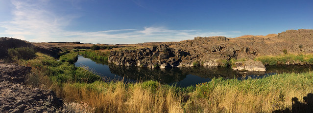
Within BLM’s Rock Creek Management Area, Rock Creek flows through Channeled Scablands, formed approximately 12,000 years ago by massive Glacial Lake Missoula floods. Striking landscapes and geologic features including buttes, mesas, and columnar basalt outcrops enhance the beauty of perennial Rock Creek.
The area’s developed Rock Creek Recreation Site is located within view of Rock Creek. It is the area’s primary parking and excursion starting point, via its multiple trailheads, as well as for overland hiking and horseback riding trips.
Especially popular activities are hiking, horseback riding, trout fishing, hunting, mountain biking, picnicking, camping, wildlife and wildflower viewing, photography, and natural and cultural history appreciation.
Although mostly unmaintained, more than 20 miles of non-motorized trails are available. Motorized use is allowed on the recreation site access road, Breeden Road, and Towell Falls Road when/if seasonally open.
Know Before You Go:
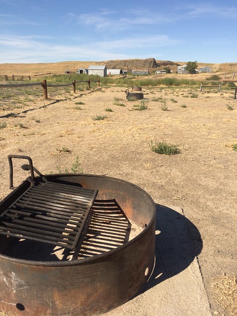
- The east side of the recreation site is for vehicle parking, picnicking, and camping. It has 3 developed campsites each with a fire ring and a picnic table. You’ll also find 2 additional picnic tables within a picnic shelter and a vault toilet.
- The west side of the recreation site is separated from the east side by a wood fence. It is an equestrian/RV loop parking and camping area with six RV parking slots. It has two small corrals (one with a perennial spring-fed stock water trough), high line poles (rope not provided), and a manure bin with wheelbarrow. Additional equestrian amenities (more corrals + 2 campsites with picnic table and fire ring) will be added in spring 2021.
- Towell Falls Road this year is not seasonally open to vehicle travel. That 3-mile long trail/road (with its trailhead at the recreation site) remains open to hiking, equestrian, and biking (and other non-motorized mechanized use).
- When recreating on public lands, please practice Leave-No-Trace Principles.
- Beware of rattlesnakes, especially from May through October.
Point of Interest:
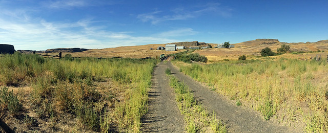
From the recreation site, visitors can mosey across the bridge over Rock Creek and explore the historic Escure Ranch, operated for sheep and cattle from the 1930s to the 1980s.
Getting there
From Sprague, Washington: Travel south on Highway 23 for 12.2 miles and turn right onto Davis Road. At 4 miles, stay to the right at the “y”. Continue south for 3 more miles and turn left onto Jordan Knott Road. Travel 2.1 miles and turn right onto the BLM access road, marked with a BLM Rock Creek Management Area sign. Travel 2 miles to the recreation site at road’s end.
47.01468, -117.94328 · 47°0'52.8"N 117°56'35.8"W
Typical weather
Typically 90°F in Jul, down to 38°F in Dec.
| Jan | Feb | Mar | Apr | May | Jun | Jul | Aug | Sep | Oct | Nov | Dec | |
|---|---|---|---|---|---|---|---|---|---|---|---|---|
| High °F | 39 | 45 | 54 | 62 | 72 | 79 | 90 | 89 | 79 | 63 | 47 | 38 |
| Low °F | 26 | 27 | 31 | 36 | 42 | 48 | 53 | 52 | 44 | 36 | 30 | 25 |
| Precip in | 2.0 | 1.3 | 1.7 | 1.3 | 1.3 | 1.0 | 0.3 | 0.3 | 0.5 | 1.1 | 2.0 | 2.4 |
1991–2020 averages from the nearest NOAA station, 14 mi away — not measured at the facility itself, and elevation can make a real difference over that distance.
Map
Fees and stay limits
No fees.
Stay limit: 14 days.
From Recreation.gov, which is not always current. The operator's own page is the authority on what you will be charged.
More photos
Member photos
Common questions about Rock Creek Recreation Site
- Can you reserve a site at Rock Creek Recreation Site?
- No. Rock Creek Recreation Site is not reservable through Recreation.gov, so sites are first-come, first-served or booked elsewhere.
- How long can you stay at Rock Creek Recreation Site?
- 14 days.
Camping near Rock Creek Recreation Site
- Tucannon Guard Station 54.3 mi · Campground · we watch it
- Crab Creek - Rocky Ford Area 24.6 mi · Facility
- Pomeroy Ranger District 40 mi · Facility
- Coffeepot Lake Recreation Site 44.2 mi · Facility
- Windust Park 45 mi · Campground
- Pacific Lake Recreation Site - Lakeview Ranch 46.3 mi · Facility
- University of Idaho/Lionel Hampton Center 48.7 mi · Facility
- Northwest Museum of Arts and Culture 50.1 mi · Facility
- Forest Boundary Campground 53.1 mi · Campground
- Pataha Campground 53.9 mi · Campground
- Tucannon Campground 54.7 mi · Campground
- Alder Thicket Campground 55.2 mi · Campground
Contact
- Phone 509-536-1200
- Email BLM_OR_SP_Mail@blm.gov
- Info Recreation.gov
Recreation.gov last updated this record on 2026-02-25.
Facility information and photographs from Recreation.gov (RIDB). SpotOpened is not affiliated with Recreation.gov or any federal agency.
Comments