Raccoon Branch Campground
Campground · Virginia · 17 bookable sites ·
Managed by the USDA Forest Service
Mount Rogers National Recreation Area (National Recreation Area) · Open Access
- 17
- Bookable sites
- 60 ft
- Max rig length
- up to 8
- People per site
- 2,735 ft
- Elevation
Overview
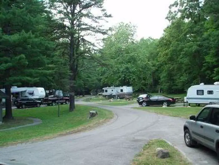
Raccoon Branch Campground, nestled at the base of Dickey Knob, offers scenic mountain views, hiking trail access from campsites and cool mountain streams. Campers can access Dickey Creek and the Raccoon Branch from the campground. The most notable time to visit is fall, when the trees boast gorgeous fall foliage.With a location just 11 miles from Interstate 81, the beautiful campground is easily reached by drivers heading out from one of the surrounding cities.
Recreation
The beautiful Dickey Knob Trail takes hikers through a Wilderness to the top of Dickey Knob for spectacular views of Sugar Grove and Rye Valley. The creek provides a setting for wading and fishing.Facilities
Every site accommodates RV or tent camping and five campsites have electric hookups. Perks of the campground include flush toilets, drinking water, paved roads and spurs and a dump station. There are no showers. A volunteer host is onsite to welcome visitors and offer advice on the region.
Natural Features
The campground is at an elevation of 2,880 ft., along a large grassy area, surrounded by pines, hardwoods and rhododendrons. Perched in the Appalachian Mountains, Raccoon Branch is part of the Mount Rogers National Recreation Area, a 200,000-acre stretch of designated wilderness areas.Nearby Attractions
Hike the Appalachian Trail, which extends more than 2,175 miles throughout the Appalachian Mountains across 14 states. The trail was designated as the first National Scenic Trail. The Virginia Creeper Trail, Hungry Mother State Park and Grayson Highlands State Park are nearby.The facts
- Season: mid-April – late-November — USDA Forest Service, Aug 24, 2026
- 17 bookable sites
- 20 sites in total, including non-bookable
- Vehicles up to 60 ft
- Up to 8 people per site
- Loops: RABC
Site types
- 12 Standard Nonelectric
- 5 Standard Electric
- 3 Management
Amenities
- Electric hookups
- Water hookups
- Picnic tables
- Shade
- Pets allowed
Not recorded upstream: sewer hookups, campfires allowed, fire pits, grills.
20 campsites at Raccoon Branch Campground
Check-in 2:00 PM · Check-out 12:00 PM
| Site | Loop | Type | Entry | Surface | Max rig | People | |
|---|---|---|---|---|---|---|---|
| 001 | RABC | Standard Nonelectric | Back In | Paved | 25 ft | 8 | 🐾 |
| 002 | RABC | Standard Nonelectric | Back In | Paved | 20 ft | 8 | 🐾 |
| 003 | RABC | Standard Nonelectric | Back In | Paved | 35 ft | 8 | 🐾 |
| 004 | RABC | Standard Nonelectric | Back In | Paved | 30 ft | 8 | 🐾 |
| 005 | RABC | Standard Nonelectric | Back In | Paved | 25 ft | 8 | 🐾 |
| 006 | RABC | Standard Nonelectric | Back In | Paved | 25 ft | 8 | 🐾 |
| 007 | RABC | Standard Nonelectric | Back In | Paved | 30 ft | 8 | 🐾 |
| 008 | RABC | Standard Nonelectric | Back In | Paved | 35 ft | 8 | 🐾 |
| 009 | RABC | Standard Nonelectric | Back In | Paved | 45 ft | 8 | 🐾 |
| 010 | RABC | Standard Electric | Back In | Paved | 35 ft | 8 | 🐾 |
| 011 | RABC | Standard Electric | Back In | Paved | 60 ft | 8 | 🐾 |
| 012 | RABC | Management | Back In | Paved | 25 ft | 8 | 🐾 |
| 013 | RABC | Standard Electric | Back In | Paved | 35 ft | 8 | 🐾 |
| 014 | RABC | Standard Nonelectric | Back In | Paved | 30 ft | 8 | 🐾 |
| 015 | RABC | Standard Electric | Back In | Paved | 50 ft | 8 | 🐾 |
| 016 | RABC | Standard Nonelectric | Back In | Paved | 30 ft | 8 | 🐾 |
| 017 | RABC | Standard Electric | Back In | Paved | 40 ft | 8 | 🐾 |
| 018 | RABC | Management | Back In | Paved | 40 ft | 8 | 🐾 |
| 019 | RABC | Standard Nonelectric | Back In | Paved | 35 ft | 8 | 🐾 |
| 020 | RABC | Management | Back In | Paved | 40 ft | 8 | 🐾 |
Getting there
36.74749, -81.42474 · 36°44'51.0"N 81°25'29.1"W
Typical weather
| Jan | Feb | Mar | Apr | May | Jun | Jul | Aug | Sep | Oct | Nov | Dec | |
|---|---|---|---|---|---|---|---|---|---|---|---|---|
| High °F | — | — | — | — | — | — | — | — | — | — | — | — |
| Low °F | — | — | — | — | — | — | — | — | — | — | — | — |
| Precip in | 3.7 | 3.2 | 4.3 | 4.1 | 5.1 | 4.4 | 5.1 | 4.1 | 3.5 | 2.8 | 2.7 | 3.5 |
1991–2020 averages from the nearest NOAA station, 6.5 mi away — not measured at the facility itself, and elevation can make a real difference over that distance.
Map
More photos


Member photos
Common questions about Raccoon Branch Campground
- Can you reserve a site at Raccoon Branch Campground?
- Yes, Raccoon Branch Campground is reservable through Recreation.gov.
- How many campsites does Raccoon Branch Campground have?
- 20 sites in total, of which 17 can be booked.
- What is the maximum RV length at Raccoon Branch Campground?
- 60 ft. That is the longest vehicle the sites here are recorded as taking; individual sites may be shorter.
- Are pets allowed at Raccoon Branch Campground?
- Yes, pets are allowed at Raccoon Branch Campground.
- Does Raccoon Branch Campground have hookups?
- Electric, Water.
Also listed by
Raccoon Branch Campground also appears in other federal recreation data. Facts below are matched by name and location, not confirmed by Raccoon Branch Campground's operator.
USDA Forest Service — data as of Aug 24, 2026
- $20 per site per night. $7 hookup fee.
Camping near Raccoon Branch Campground
- Hurricane Campground 3.9 mi · Campground · we watch it
- Old Virginia Group Horse Camp 5 mi · Campground · we watch it
- Fox Creek Horse Camp 5.6 mi · Campground · we watch it
- Grindstone 7.7 mi · Campground · we watch it
- Blue Springs Gap Cabin 8.6 mi · Campground · we watch it
- Comer's Rock Recreation Area 11.2 mi · Campground · we watch it
- Beartree 13.1 mi · Campground · we watch it
- Hussy Mountain Horse Camp 15.6 mi · Campground · we watch it
- Pat Jennings Visitor Center 4.4 mi · Facility
- Comers Rock Recreation Area 11.1 mi · Facility
- Whitetop Station Visitor Center 14.1 mi · Facility
- Beartree Recreation Area 15.3 mi · Campground
Contact
- Phone 800-628-7202
- Email sm.fs.mrnra@usda.gov
- Book Recreation.gov
Recreation.gov last updated this record on 2026-02-25.
Facility information and photographs from Recreation.gov (RIDB). SpotOpened is not affiliated with Recreation.gov or any federal agency.
Comments