Comer's Rock Recreation Area
Campground · Virginia · 1 bookable site ·
Managed by the USDA Forest Service
Mount Rogers National Recreation Area (National Recreation Area) · Open Access
- 1
- Bookable site
- up to 16
- People per site
- 2
- Accessible sites
- 3,783 ft
- Elevation

Overview
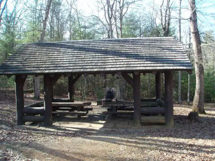
This historic log picnic shelter was built by the Civilian Conservation Corps. It is located next to Comers Rock Campground in the heart of the Mount Rogers National Recreation Area.Recreation
There are primitive campsites available in the adjoing campground for $5.00 per night (first-come, first-served) and vault toilets are available. There are hiking trails in the area, including into Dry Run Wilderness, which is within walking distance from the campground and shelter.Facilities
There are vault toilets available. There are picnic tables and a large fire place. Parking is available. Drinking water is not available
Natural Features
Hale Lake is nearby for fishing, or stop at Comers Rock Overlook for breath taking long distance views of the valley.Nearby Attractions
Hale Lake for fishing and Comers Rock Overlook for wonderful views.The facts
- 1 bookable site
- 2 sites in total, including non-bookable
- 1 site for day use only
- 2 accessible sites
- Up to 16 people per site
- Loops: Comers Rock Campground, S&P
Site types
- 1 Group Shelter Nonelectric
- 1 Management
Amenities
- Campfires allowed
- Fire pits
- Picnic tables
- Grills
- Shade
- Pets allowed
Not recorded upstream: electric hookups, water hookups, sewer hookups.
2 campsites at Comer's Rock Recreation Area
| Site | Loop | Type | Entry | Surface | Max rig | People | |
|---|---|---|---|---|---|---|---|
| 01 | Comers Rock Campground | Group Shelter Nonelectric | — | Gravel | — | 16 | ♿ 🐾 |
| Single, S&P | S&P | Management | — | Gravel | — | 8 | ♿ 🐾 |
Getting there
36.76302, -81.22411 · 36°45'46.9"N 81°13'26.8"W
Typical weather
Typically 79°F in Jul, down to 41°F in Jan.
| Jan | Feb | Mar | Apr | May | Jun | Jul | Aug | Sep | Oct | Nov | Dec | |
|---|---|---|---|---|---|---|---|---|---|---|---|---|
| High °F | 41 | 45 | 52 | 62 | 69 | 76 | 79 | 77 | 72 | 63 | 54 | 46 |
| Low °F | 22 | 25 | 31 | 41 | 52 | 59 | 63 | 61 | 55 | 44 | 35 | 27 |
| Precip in | — | — | — | — | — | — | — | — | — | — | — | — |
1991–2020 averages from the nearest NOAA station, 6.5 mi away — not measured at the facility itself, and elevation can make a real difference over that distance.
Map
More photos
Member photos
Common questions about Comer's Rock Recreation Area
- Can you reserve a site at Comer's Rock Recreation Area?
- Yes, Comer's Rock Recreation Area is reservable through Recreation.gov.
- How many campsites does Comer's Rock Recreation Area have?
- 2 sites in total, of which 1 can be booked.
- Are pets allowed at Comer's Rock Recreation Area?
- Yes, pets are allowed at Comer's Rock Recreation Area.
- Are campfires allowed at Comer's Rock Recreation Area?
- Campfires are allowed at Comer's Rock Recreation Area. Check for a current fire restriction before you go.
Camping near Comer's Rock Recreation Area
- Blue Springs Gap Cabin 2.6 mi · Campground · we watch it
- Hussy Mountain Horse Camp 4.5 mi · Campground · we watch it
- Raven Cliff Recreation Area 10.2 mi · Campground · we watch it
- Collins Cove Horse Campground 11.1 mi · Campground · we watch it
- Raccoon Branch Campground 11.2 mi · Campground · we watch it
- Sunrise Cabin 12.9 mi · Campground · we watch it
- Hurricane Campground 14.9 mi · Campground · we watch it
- Old Virginia Group Horse Camp 15.3 mi · Campground · we watch it
- Fox Creek Horse Camp 16.1 mi · Campground · we watch it
- Stony Fork Campground 17.2 mi · Campground · we watch it
- Comers Rock Recreation Area less than 0.1 mi · Facility
- Pat Jennings Visitor Center 11.4 mi · Facility
Contact
- Phone 276-783-5196
- Email sm.fs.mrnra@usda.gov
- Book Recreation.gov
Recreation.gov last updated this record on 2026-02-25.
Facility information and photographs from Recreation.gov (RIDB). SpotOpened is not affiliated with Recreation.gov or any federal agency.
Comments