Storm Mountain Day Use Area
Campground · Utah · 20 bookable sites ·
Managed by the USDA Forest Service
Wasatch National Forest (NF) · Open Access
- 20
- Bookable sites
- 18 ft
- Max rig length
- up to 200
- People per site
- 19
- Accessible sites
- 5,809 ft
- Elevation
Overview
Storm Mountain Day Use Area is just 3 miles up Big Cottonwood Canyon, conveniently close to Salt Lake City. Big Cottonwood Creek runs alongside the site. Visitors enjoy fishing, hiking and biking.Recreation
Big Cottonwood Creek flows through the area, offering trout fishing. Hiking and mountain biking are popular activities on canyon trails.Facilities
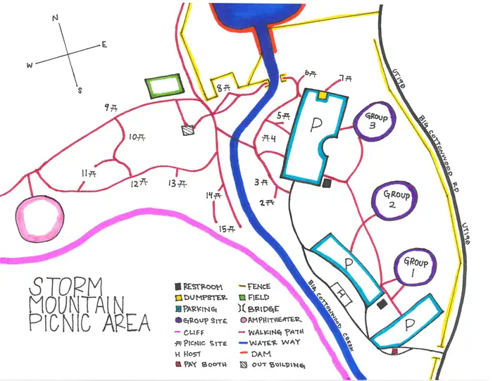
The picnic area contains four group sites and several single sites, most of which are accessible. All contain picnic tables and campfire rings. Some sites have grills and serving tables. A historic stone amphitheater is available for reservations.
Flush toilets are provided but picnickers must bring their own drinking water. Horseshoe pits are on-site. Roads, parking spurs and footpaths are paved. This picnic area is located in a watershed area and no pets are allowed.
Natural Features
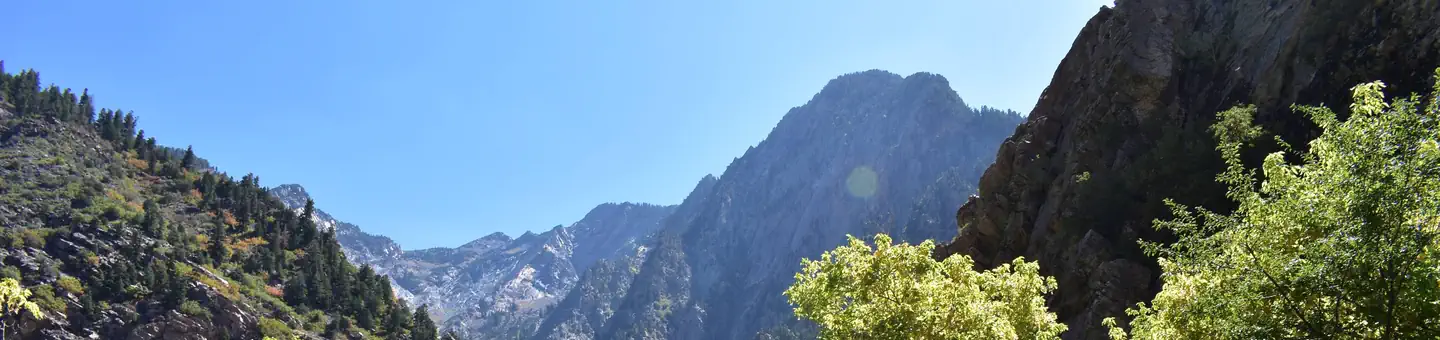
The picnic area is set among shady oaks and aspens at the foot of rugged Storm Mountain. Vivid summer wildflowers are abundant and autumn leaves put on quite a show.Contact Info
For facility specific information, please call (385) 273-1100.Nearby Attractions
Big Cottonwood Canyon is a beautiful area known for its soaring peaks, pristine hidden lakes and cascading streams. Numerous hiking and mountain biking trails are in the area. Rock climbing is a popular activity as well.Solitude Mountain Resort is 10 miles up-canyon, offering scenic chairlift rides, hiking, a few dining options and a challenging 18-hole disc golf course.
Silver Lake is another mile past Solitude. Fishing and canoeing are popular activities. An easy trail loops around the small lake.
Charges & Cancellations
Change and Cancellation Policies and Fees
- Overnight and Day Use Facilities: To ensure fairness, reservation arrival or departure dates may not be changed beyond the booking window until 18 days after booking the reservation.
- Camping / Day Use: A $10.00 service fee will apply if you change or cancel your reservation (including campsites, cabins, lookouts, group facilities, etc.). The $10.00 service fee will be deducted from the refund amount.
- You can cancel or change reservations through Recreation.gov or by calling 1-877-444-6777.
Late Cancellations
- Overnight and Day Use Facilities: Late cancellations are those cancelled between 12:01 a.m. (Eastern) on the day before arrival and check out time on the day after arrival.
- Individual Campsites: If a customer cancels a reservation the day before or on the day of arrival they will be charged a $10.00 service fee and will also forfeit the first night's use fee (not to exceed the total paid for the original reservation). Cancellations for a single night's reservation will forfeit the entire use fee but no cancellation fee will apply.
- Cabins / Lookouts: Customers will be charged a $10.00 cancellation fee and forfeit the first night's use fee if a cabin or lookout reservation is cancelled within 14 days of the scheduled arrival date. Cancellations for a single night's use will not be assessed a service fee.
- Group Facility: If a customer cancels a group overnight facility reservation within 14 days of the scheduled arrival date they will be charged the $10.00 service fee and forfeit the first night's use fee. Cancellations for a single night's use will not be assessed a service fee.
- Group Day Use Area: If a customer cancels a group day use facility reservation within 14 days of the scheduled arrival date, they will forfeit the total day use fee with no service fee charge.
No-Shows
- Camping / Day Use: A camping no-show customer is one who does not arrive at a campground and does not cancel the reservation by check-out time on the day after the scheduled arrival date. Reserved campsites and group overnight facilities will be held until check-out time on the day following your scheduled arrival. Group day-use facilities will be held until check-in time on your scheduled arrival date.
- If a customer does not arrive at the campground or group facility by check-out time the day after arrival or does not cancel the reservation by the times listed under "Late Cancellations" above, the customer may be assessed a $20.00 service fee and forfeit use fees.
Refunds
- Customers must request refunds no later than 14 days after the scheduled departure date. Recreation.gov will not grant refund requests after 14 days of departure.
- Reservation Fee: For some facilities, tours or permits an additional reservation fee is charged. For some overnight and day-use facilities, an additional non-refundable reservation fee may apply. The non-refundable reservation fee for tours and tickets is $1.00. The non-refundable reservation fee for permits varies by location.
- Refunds for Bankcard Purchases: Refunds for bank card payments will be issued as a credit to the original bank card.
- Refunds for Check or Cash Purchases: Refunds for Recreation.gov payments made by check or money order, and cash payments at selected campgrounds will be issued a check refund. A refund will be processed within 30 days of receipt and approval. Please Note: Refund requests made during or after departure can only be processed when approved by the facility management staff based upon local policy.
- Refunds for Emergency Closures: In the event of an emergency closure, the Recreation.gov team will attempt to notify users and offer alternate dates (as appropriate). If this is not possible, reservations will be cancelled and all fees paid will be refunded. Reservation fees for free tickets are non-refundable in the event of an emergency closure.
Recreation.gov Billing Information
- Reservation transaction will appear on customer's credit card statements as "Recreation.gov 877-444-6777."
Changes to Policies and Procedures
- Recreation.gov reserves the right, when necessary, to modify reservation policies. These policies were last updated July 2018.
The facts
- 20 bookable sites
- 20 sites for day use only
- 19 accessible sites
- Vehicles up to 18 ft
- Up to 200 people per site
- Loops: Amphitheater, Day Use, Group Site
Site types
- 14 Picnic
- 6 Group Picnic Area
Amenities
- Campfires allowed
- Fire pits
- Picnic tables
- Shade
- Water hookups — not available
Not recorded upstream: electric hookups, sewer hookups, grills, pets allowed.
20 campsites at Storm Mountain Day Use Area
| Site | Loop | Type | Entry | Surface | Access | Max rig | People | |
|---|---|---|---|---|---|---|---|---|
| AAFT | Amphitheater | Group Picnic Area | — | Paved | — | 18 ft | 200 | ♿ |
| AEVE | Amphitheater | Group Picnic Area | — | Paved | — | 18 ft | 200 | ♿ |
| AMORN | Amphitheater | Group Picnic Area | — | Paved | — | 18 ft | 200 | ♿ |
| 002 | Day Use | Picnic | — | Paved | — | 18 ft | 8 | ♿ |
| 003 | Day Use | Picnic | — | Paved | — | 18 ft | 8 | ♿ |
| 004 | Day Use | Picnic | — | Paved | — | 18 ft | 8 | ♿ |
| 005 | Day Use | Picnic | — | Paved | — | 18 ft | 8 | ♿ |
| 006 | Day Use | Picnic | — | Paved | — | 18 ft | 8 | ♿ |
| 007 | Day Use | Picnic | — | Paved | — | 18 ft | 8 | ♿ |
| 008 | Day Use | Picnic | — | Paved | — | 18 ft | 8 | ♿ |
| 009 | Day Use | Picnic | Back In | Paved | Hike In | 18 ft | 16 | |
| 010 | Day Use | Picnic | — | Paved | — | 18 ft | 8 | ♿ |
| 011 | Day Use | Picnic | — | Paved | — | 18 ft | 8 | ♿ |
| 012 | Day Use | Picnic | — | Paved | — | 18 ft | 8 | ♿ |
| 013 | Day Use | Picnic | — | Paved | — | 18 ft | 8 | ♿ |
| 014 | Day Use | Picnic | — | Paved | — | 18 ft | 8 | ♿ |
| 015 | Day Use | Picnic | — | Paved | — | 18 ft | 8 | ♿ |
| G1 | Group Site | Group Picnic Area | — | Paved | — | 18 ft | 50 | ♿ |
| G2 | Group Site | Group Picnic Area | — | Paved | — | 18 ft | 50 | ♿ |
| G3 | Group Site | Group Picnic Area | — | Paved | — | 18 ft | 50 | ♿ |
Getting there
40.62333, -111.74306 · 40°37'24.0"N 111°44'35.0"W
Typical weather
Typically 91°F in Jul, down to 38°F in Jan.
| Jan | Feb | Mar | Apr | May | Jun | Jul | Aug | Sep | Oct | Nov | Dec | |
|---|---|---|---|---|---|---|---|---|---|---|---|---|
| High °F | 38 | 44 | 54 | 61 | 71 | 82 | 91 | 89 | 79 | 64 | 49 | 38 |
| Low °F | 23 | 27 | 34 | 40 | 48 | 57 | 68 | 66 | 56 | 43 | 32 | 23 |
| Precip in | 2.2 | 2.3 | 2.7 | 3.3 | 2.8 | 1.4 | 0.6 | 0.9 | 1.6 | 2.1 | 2.1 | 2.4 |
1991–2020 averages from the nearest NOAA station, 2.1 mi away — not measured at the facility itself, and elevation can make a real difference over that distance.
Map
Fees and stay limits
Cash, Check, or Scan & Pay Amphitheater (4 hour blocks: 8am-12pm, 1pm-5pm, 6pm-10pm) - $159.00 - capacity - 200 people + 15 vehicle 3 Group Day Use sites - $153.00 - capacity - 50 people + 8 vehicle Day Use - $15.00 + 1 vehicle Walk-in - $8.00 per person Parking - $15.00 per vehicle Big Cottonwood Canyon Season Day Use Pass - $95.00* *This pass includes entrance to Mueller Park and Big Cottonwood Canyon day-use areas (Strom Mtn., Dogwood, Birches, Ledgemere). Pass does NOT include access to group sites, amphitheaters, or glamping sites.
From Recreation.gov, which is not always current. The operator's own page is the authority on what you will be charged.
More photos

Member photos
Common questions about Storm Mountain Day Use Area
- Can you reserve a site at Storm Mountain Day Use Area?
- Yes, Storm Mountain Day Use Area is reservable through Recreation.gov.
- How many campsites does Storm Mountain Day Use Area have?
- 20 sites.
- What is the maximum RV length at Storm Mountain Day Use Area?
- 18 ft. That is the longest vehicle the sites here are recorded as taking; individual sites may be shorter.
- Does Storm Mountain Day Use Area have hookups?
- No hookups are recorded here.
- Are campfires allowed at Storm Mountain Day Use Area?
- Campfires are allowed at Storm Mountain Day Use Area. Check for a current fire restriction before you go.
Camping near Storm Mountain Day Use Area
- Birches Picnic Area 0.7 mi · Campground · we watch it
- Ledgemere Picnic Area 1 mi · Campground · we watch it
- Dogwood Day Use 1.4 mi · Campground · we watch it
- Tanners Flat 4.2 mi · Campground · we watch it
- Jordan Pines 5.3 mi · Campground · we watch it
- Spruces - Big Cottonwood 5.7 mi · Campground · we watch it
- Albion Basin 7.6 mi · Campground · we watch it
- Redman Campground 8.1 mi · Campground · we watch it
- Granite Flat (Utah) 10.5 mi · Campground · we watch it
- Little Mill 12.6 mi · Campground · we watch it
- Spruces Campground 5.7 mi · Campground
- Timpanogos Cave Visitor Center 12.6 mi · Facility
Contact
- Phone SALT LAKE RANGER DISTRICT OFFICE 801-733-2660 OR UTAH RECREATION COMPANY 385-273-1100
- Email comments@AmericanLL.com
- Book Recreation.gov
Recreation.gov last updated this record on 2026-03-11.
Facility information and photographs from Recreation.gov (RIDB). SpotOpened is not affiliated with Recreation.gov or any federal agency.
Comments