Panther Bay Park
Campground · 15 bookable sites ·
Managed by the US Army Corps of Engineers
Norfork Recreation Area (Recreation Area) · Open Access
- 15
- Bookable sites
- 68 ft
- Max rig length
- up to 50
- People per site
- 16
- Accessible sites
- 637 ft
- Elevation

Overview
Panther Bay is conveniently located between the Highway 62 and 101 bridges allowing quick and easy access to several hiking trails, marinas, and boat ramps.
Recreation
Hiking trails in the area lead nature observers and photographers to picturesque overlooks of the Ozarks. A wide array of fresh water game fish are found in the lake, which is fed by the North Fork River and its tributaries. Bass, walleye, crappie, bream and catfish all make their home here.
Facilities
The campground offers 15 campsites, all with electric hookups and water available for filling holding tanks.
Panther Bay Marina and several boat ramps are located nearby to provide easy access to the recreational activities that Norfork Lake has to offer.
Natural Features
Norfork Lake covers 22,000 acres with 550 miles of shoreline. Densely wooded hills and hollows surround the lake in the Ozark Mountains. The North Fork River feeds into the lake, and beyond the dam, extends on to connect with the White River.
Nearby Attractions
Hike the Robinson Point National Recreation Trail for wonderful views of the Ozarks.
Just south of the lake, The Ozark National Forest spans 1.2 million acres.
Contact Info
For facility specific information, please call (870) 425-2700.Charges & Cancellations
Cancellations up to 2 days before a reservation start date incur a $10.00 cancellation fee.
The facts
- 15 bookable sites
- 16 sites in total, including non-bookable
- 1 site for day use only
- 16 accessible sites
- Vehicles up to 68 ft
- Up to 50 people per site
- Loops: Panther Bay Park
Site types
- 14 Standard Electric
- 1 Group Shelter Electric
- 1 Management
Amenities
- Electric hookups
- Water hookups
- Campfires allowed
- Pets allowed
Not recorded upstream: sewer hookups, fire pits, picnic tables, grills, shade.
16 campsites at Panther Bay Park
| Site | Loop | Type | Entry | Surface | Max rig | People | |
|---|---|---|---|---|---|---|---|
| 10 | Panther Bay Park | Standard Electric | — | — | 50 ft | 10 | ♿ 🐾 |
| 11 | Panther Bay Park | Standard Electric | — | — | 64 ft | 10 | ♿ 🐾 |
| 12 | Panther Bay Park | Standard Electric | — | — | 40 ft | 10 | ♿ 🐾 |
| 13 | Panther Bay Park | Standard Electric | — | — | 40 ft | 10 | ♿ 🐾 |
| 14 | Panther Bay Park | Standard Electric | — | — | 48 ft | 10 | ♿ 🐾 |
| 15 | Panther Bay Park | Standard Electric | — | — | 55 ft | 10 | ♿ 🐾 |
| 16 | Panther Bay Park | Standard Electric | — | — | — | 10 | ♿ 🐾 |
| 17 | Panther Bay Park | Standard Electric | — | — | 48 ft | 10 | ♿ 🐾 |
| 18 | Panther Bay Park | Standard Electric | — | — | 58 ft | 10 | ♿ 🐾 |
| 19 | Panther Bay Park | Management | — | — | 68 ft | 10 | ♿ 🐾 |
| 20 | Panther Bay Park | Standard Electric | — | — | 36 ft | 10 | ♿ 🐾 |
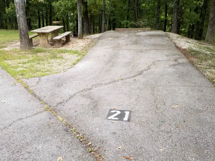
| 21 | Panther Bay Park | Standard Electric | — | — | 36 ft | 10 | ♿ 🐾 |
| 22 | Panther Bay Park | Standard Electric | — | — | 45 ft | 10 | ♿ 🐾 |
| 8 | Panther Bay Park | Standard Electric | — | — | 56 ft | 10 | ♿ 🐾 |
| 9 | Panther Bay Park | Standard Electric | — | — | 40 ft | 10 | ♿ 🐾 |
| GS1 | Panther Bay Park | Group Shelter Electric | — | — | — | 50 | ♿ 🐾 |
Getting there
From Mountain Home, AR, travel approximately 10 miles east on US 412/62. The entrance to the campground will be on the left just before you cross the 62 bridge. Follow signs into campground.
36.37051, -92.25056 · 36°22'13.9"N 92°15'2.0"W
Typical weather
| Jan | Feb | Mar | Apr | May | Jun | Jul | Aug | Sep | Oct | Nov | Dec | |
|---|---|---|---|---|---|---|---|---|---|---|---|---|
| High °F | — | — | — | — | — | — | — | — | — | — | — | — |
| Low °F | — | — | — | — | — | — | — | — | — | — | — | — |
| Precip in | 3.1 | 3.0 | 4.5 | 5.3 | 5.1 | 3.7 | 4.0 | 3.4 | 3.6 | 3.6 | 4.3 | 3.6 |
1991–2020 averages from the nearest NOAA station, 3.3 mi away — not measured at the facility itself, and elevation can make a real difference over that distance.
Map
More photos

Member photos
Common questions about Panther Bay Park
- Can you reserve a site at Panther Bay Park?
- Yes, Panther Bay Park is reservable through Recreation.gov.
- How many campsites does Panther Bay Park have?
- 16 sites in total, of which 15 can be booked.
- What is the maximum RV length at Panther Bay Park?
- 68 ft. That is the longest vehicle the sites here are recorded as taking; individual sites may be shorter.
- Are pets allowed at Panther Bay Park?
- Yes, pets are allowed at Panther Bay Park.
- Does Panther Bay Park have hookups?
- Electric, Water.
- Are campfires allowed at Panther Bay Park?
- Campfires are allowed at Panther Bay Park. Check for a current fire restriction before you go.
Camping near Panther Bay Park
- Henderson Park 1.1 mi · Campground · we watch it
- Bidwell Point Park 1.3 mi · Campground · we watch it
- Robinson Point 1.4 mi · Campground · we watch it
- Gamaliel 3.8 mi · Campground · we watch it
- Cranfield Park 4.6 mi · Campground · we watch it
- Dam - Quarry 7.8 mi · Campground · we watch it
- Udall Park 12.1 mi · Campground · we watch it
- Lakeview Park 16.5 mi · Campground · we watch it
- Oakland Park 21.6 mi · Campground · we watch it
- Barkshed Campground 24.3 mi · Campground · we watch it
- Norfork National Fish Hatchery 8.4 mi · Facility
- Rush Campground 23.9 mi · Campground
Contact
- Book Recreation.gov
Recreation.gov last updated this record on 2026-06-16.
Facility information and photographs from Recreation.gov (RIDB). SpotOpened is not affiliated with Recreation.gov or any federal agency.
Comments