Landslide
Campground · 8 bookable sites ·
Managed by the USDA Forest Service
Sequoia National Forest (NF) · Open Access
- 8
- Bookable sites
- up to 6
- People per site
- 5,766 ft
- Elevation
Overview
Landslide campground is at 5800' elevation and within Giant Sequoia National Monument.
Recreation
Recreational opportunities abound with Hume Lake nearby, many miles of OHV roads, and hiking trails that can be found within the National Monument and nearby Sequoia and Kings Canyon National Parks.
Facilities
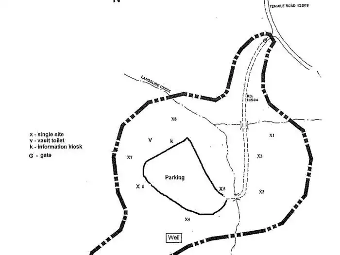
5800-foot elevation. Nine campsites, including six tent-only sites, with hiking in two nearby groves of giant sequoias. This campground is within the Giant Sequoia National Monument. Trails in the monument, open to hikers, horses, and bikes (outside the wilderness areas), wind through giant sequoia groves, up mountains, and alongside wild rivers. Compacted dirt surfaces, fee required Maximum RV length 16 feet. Special food storage rule in effect because this is black bear country! Check current fire restrictions before venturing out.
Campfire permits are required for campfires, barbeques, and camp stoves. Permits are available at your local Ranger Station or online at Campfire Permit - Ready for Wildfire.
Natural Features
This campground is surrounded by a mixed conifer forest and sits along Landslide Creek.
Nearby Attractions
Kings Canyon National Park
Sequoia National Park
General Sherman Tree
The General Grant Tree
Hume Lake Recreation Area
Contact Info
For facility specific information, please call (661) 702-1420.The facts
- 8 bookable sites
- Up to 6 people per site
- Loops: Landslide
Site types
- 8 Tent Only Nonelectric
Amenities
- Campfires allowed
- Fire pits
- Picnic tables
- Pets allowed
- Water hookups — not available
- Shade — not available
Not recorded upstream: electric hookups, sewer hookups, grills.
8 campsites at Landslide
Check-in 02:00 PM · Check-out 12:00 PM
| Site | Loop | Type | Entry | Surface | Max rig | People | |
|---|---|---|---|---|---|---|---|
| 2 | Landslide | Tent Only Nonelectric | — | — | — | 6 | 🐾 |
| 3 | Landslide | Tent Only Nonelectric | — | — | — | 6 | 🐾 |
| 4 | Landslide | Tent Only Nonelectric | — | — | — | 6 | 🐾 |
| 5 | Landslide | Tent Only Nonelectric | — | — | — | 6 | 🐾 |
| 6 | Landslide | Tent Only Nonelectric | — | — | — | 6 | 🐾 |
| 7 Management | Landslide | Tent Only Nonelectric | — | — | — | 6 | 🐾 |
| 8 | Landslide | Tent Only Nonelectric | — | — | — | 6 | 🐾 |
| 9 | Landslide | Tent Only Nonelectric | — | — | — | 6 | 🐾 |
Getting there
From Grant Grove, go 13 miles north on CA 180 and Hume Rd, then 3 miles south on FR13S09 past Hume Lake.
36.76375, -118.88221 · 36°45'49.5"N 118°52'56.0"W
Typical weather
Typically 79°F in Jul, down to 46°F in Dec.
| Jan | Feb | Mar | Apr | May | Jun | Jul | Aug | Sep | Oct | Nov | Dec | |
|---|---|---|---|---|---|---|---|---|---|---|---|---|
| High °F | 46 | 46 | 48 | 52 | 60 | 71 | 79 | 79 | 73 | 63 | 53 | 46 |
| Low °F | 26 | 25 | 27 | 30 | 38 | 46 | 53 | 52 | 47 | 39 | 32 | 25 |
| Precip in | 8.0 | 7.3 | 7.8 | 3.6 | 1.4 | 0.5 | 0.3 | 0.2 | 0.3 | 2.4 | 3.3 | 6.6 |
1991–2020 averages from the nearest NOAA station, 4.8 mi away — not measured at the facility itself, and elevation can make a real difference over that distance.
Map
Member photos
Common questions about Landslide
- Can you reserve a site at Landslide?
- Yes, Landslide is reservable through Recreation.gov.
- How many campsites does Landslide have?
- 8 sites.
- Are pets allowed at Landslide?
- Yes, pets are allowed at Landslide.
- Does Landslide have hookups?
- No hookups are recorded here.
- Are campfires allowed at Landslide?
- Campfires are allowed at Landslide. Check for a current fire restriction before you go.
Also listed by
Landslide also appears in other federal recreation data. Facts below are matched by name and location, not confirmed by Landslide's operator.
USDA Forest Service — data as of Aug 24, 2026
- Campsite fees range from $34/night for single unit, $68/night for double unit, $8/night for extra vehicle
Camping near Landslide
- Ten Mile Campground (Ca) 1 mi · Campground · we watch it
- Logger Flat Group 1.1 mi · Campground · we watch it
- Aspen Hollow Group (Sequoia National Forest, CA) 1.7 mi · Campground · we watch it
- Hume Lake 2.6 mi · Campground · we watch it
- Big Meadows Cabin (CA) 4.1 mi · Campground · we watch it
- Princess 4.1 mi · Campground · we watch it
- Tenmile Campground 0.9 mi · Campground
- Buck Rock Lookout 2.2 mi · Facility
- Hume Lake 2.3 mi · Facility
- Kennedy Meadows Trailhead 2.8 mi · Facility
- Quail Flat Winter Trailhead 3.3 mi · Facility
- Buck Rock Campground 3.3 mi · Campground
Contact
- Email jgross@goexplorus.com
- Book Recreation.gov
Recreation.gov last updated this record on 2026-02-25.
Facility information and photographs from Recreation.gov (RIDB). SpotOpened is not affiliated with Recreation.gov or any federal agency.
Comments