Dana Peak
Campground · Texas · 31 bookable sites ·
Managed by the US Army Corps of Engineers
Stillhouse Recreation Area (REC) · Open Access
- 31
- Bookable sites
- 91 ft
- Max rig length
- up to 100
- People per site
- 668 ft
- Elevation
Overview
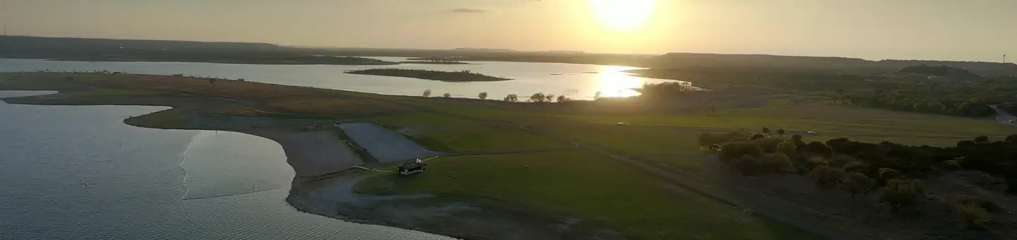
Dana Peak Campground is located on a peninsula on the shoreline of Stillhouse Hollow Lake in central Texas. The lake offers a wide variety of recreation opportunities, including water sports, hiking, biking, horseback riding, picnicking, large group pavilions, hunting, fishing and more.The facility is one of only two reservable campgrounds on the lake and often fills up on weekends during summer.
Stillhouse Hollow Lake was created by the U.S. Army Corps of Engineers with the construction of Stillhouse Hollow Dam in 1968. The 6,430-acre lake is located 16 miles upstream of the confluence of the Lampasas and Leon Rivers, which flow into the Little River.
Recreation
With 58 miles of shoreline, Stillhouse Hollow Lake is an often uncrowded haven for boaters and fishermen. The campground has a four-lane boat ramp, and visitors who do not have motor boats, canoes or kayaks can rent them nearby.Families can enjoy soaking up the sun, swimming at the beach or exploring the Dana Peak Trails (located just outside the main entrance to the park) by foot, bike or horseback.
Birding is a favorite pastime for many visitors with hawks, Great Blue herons, ducks, geese, many species of songbirds, bobwhite quail, Rio Grande turkey and even an occasional bald eagle, yielding year-round opportunities for bird sightings.
Facilities
The campground has more than 30 campsites, including RV and tent sites with electric hookups and eight primitive tent sites. The park offers restrooms with flush toilets and showers, a swimming beach, several picnic sites and a boat ramp.Primitive campsites include a picnic table and a campfire ring with a grill.
A group shelter is available by reservation for up to 80 people at a time.
Natural Features
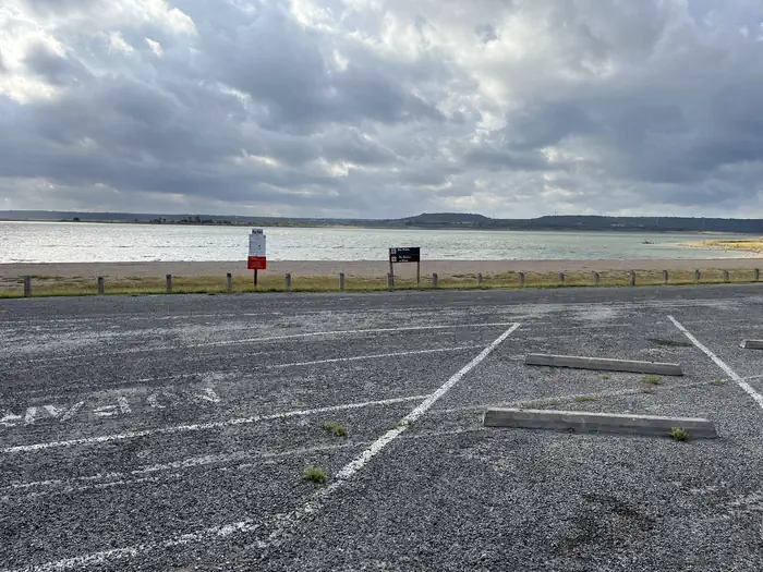
Aside from two campgrounds and a nearby day-use park, very little of the lakeshore is developed. The edges consist of rocky beaches and sandy bluffs.Much of the lake area is forested, though the campground is mostly grassy, flat and open with little to no shade. Most campsites are right along the water's edge; others are within a short walk.
The lake has noticeably clear and deep water inhabited by largemouth bass, smallmouth bass and channel catfish. A man-made wetland was constructed on the south shore of the lake, providing an additional 10 acres of wildlife habitat in the area.
Contact Info
This location is unstaffed. To speak with our main office for general information, please call: (254) 939-2461.Nearby Attractions
Within a short drive, the Village of Salado offers golf, art galleries and shopping, among other pastimes.Chalk Ridge Falls Environmental Learning Center is below the Stillhouse Hollow Lake Dam. The center has about five miles of hiking trails, including a one-mile nature trail along the Lampasas River, a spring-fed creek, a waterfall, bridges and several wildlife viewing points.
Stillhouse Hollow Lake is located near the Fort Hood Army Base, which has several points of interest for the military buff.
The facts
- 31 bookable sites
- 34 sites in total, including non-bookable
- 1 site for day use only
- Vehicles up to 91 ft
- Up to 100 people per site
- Loops: COMANCHE GAP, DANA PEAK
Site types
- 17 Standard Electric
- 8 Tent Only Nonelectric
- 5 Tent Only Electric
- 3 Management
- 1 Group Shelter Electric
Amenities
- Electric hookups
- Water hookups
- Campfires allowed
- Fire pits
- Picnic tables
- Shade
- Pets allowed
Not recorded upstream: sewer hookups, grills.
34 campsites at Dana Peak
| Site | Loop | Type | Entry | Surface | Water | Max rig | People | |
|---|---|---|---|---|---|---|---|---|
| Comanche Gap Pavilion | COMANCHE GAP | Group Shelter Electric | — | Paved | Lakefront | — | 100 | 🐾 |
| 01T | DANA PEAK | Tent Only Nonelectric | — | Paved | — | — | 8 | 🐾 |
| 02T | DANA PEAK | Tent Only Nonelectric | — | Paved | — | — | 8 | 🐾 |
| 03T | DANA PEAK | Tent Only Nonelectric | — | Paved | — | — | 8 | 🐾 |
| 04T | DANA PEAK | Tent Only Nonelectric | — | Paved | — | — | 8 | 🐾 |
| 05T | DANA PEAK | Tent Only Nonelectric | — | Paved | — | — | 8 | 🐾 |
| 06T | DANA PEAK | Tent Only Nonelectric | — | Paved | — | — | 8 | 🐾 |
| 07T | DANA PEAK | Tent Only Nonelectric | — | Paved | — | — | 8 | 🐾 |
| 08T | DANA PEAK | Tent Only Nonelectric | Back In | Paved | — | — | 8 | 🐾 |
| 09 | DANA PEAK | Management | Back In | Paved | — | 62 ft | 8 | 🐾 |
| 10 | DANA PEAK | Standard Electric | Back In | Paved | — | 64 ft | 8 | 🐾 |
| 11 | DANA PEAK | Standard Electric | Back In | Paved | — | 64 ft | 8 | 🐾 |
| 12 | DANA PEAK | Standard Electric | Back In | Paved | — | 59 ft | 8 | 🐾 |
| 13 | DANA PEAK | Standard Electric | Back In | Paved | — | 60 ft | 8 | 🐾 |
| 14 | DANA PEAK | Standard Electric | Pull Through | Paved | — | 91 ft | 8 | 🐾 |
| 15 | DANA PEAK | Standard Electric | Back In | Paved | — | 57 ft | 8 | 🐾 |
| 16 | DANA PEAK | Standard Electric | Back In | Paved | — | 64 ft | 8 | 🐾 |
| 17 | DANA PEAK | Standard Electric | Back In | Paved | — | 75 ft | 8 | 🐾 |
| 18 | DANA PEAK | Standard Electric | Back In | Paved | — | 78 ft | 16 | 🐾 |
| 19 | DANA PEAK | Standard Electric | Back In | Paved | — | 86 ft | 8 | 🐾 |
| 20 | DANA PEAK | Standard Electric | Back In | Paved | — | 68 ft | 8 | 🐾 |
| 21 | DANA PEAK | Standard Electric | Back In | Paved | — | 85 ft | 8 | 🐾 |
| 22 | DANA PEAK | Standard Electric | Back In | Paved | — | 63 ft | 8 | 🐾 |
| 23 | DANA PEAK | Standard Electric | Back In | Paved | — | 61 ft | 8 | 🐾 |
| 24 | DANA PEAK | Standard Electric | Back In | Paved | — | 78 ft | 8 | 🐾 |
| 25 | DANA PEAK | Standard Electric | Back In | Paved | — | 88 ft | 16 | 🐾 |
| 26 | DANA PEAK | Standard Electric | Back In | Paved | — | 77 ft | 8 | 🐾 |
| 27T | DANA PEAK | Tent Only Electric | Back In | Paved | — | — | 8 | 🐾 |
| 28T | DANA PEAK | Tent Only Electric | Back In | Paved | — | — | 8 | 🐾 |
| 29T | DANA PEAK | Tent Only Electric | Back In | Paved | — | — | 8 | 🐾 |
| 30T | DANA PEAK | Tent Only Electric | Back In | Paved | — | — | 8 | 🐾 |
| 31T | DANA PEAK | Tent Only Electric | Back In | Paved | — | — | 8 | 🐾 |
| Host1 | DANA PEAK | Management | Back In | Paved | — | 66 ft | 16 | 🐾 |
| Host2 | DANA PEAK | Management | Pull Through | Paved | — | 70 ft | 8 | 🐾 |
Getting there
From Interstate 35 in Belton, Texas take Highway 190 west to the Simmons Road exit. Cross under the highway and turn west on Farm-to-Market Road 2410. Turn left (south) on Commanche Gap Road and drive for five miles to reach the park.
31.02863, -97.60558 · 31°1'43.1"N 97°36'20.1"W
Typical weather
| Jan | Feb | Mar | Apr | May | Jun | Jul | Aug | Sep | Oct | Nov | Dec | |
|---|---|---|---|---|---|---|---|---|---|---|---|---|
| High °F | — | — | — | — | — | — | — | — | — | — | — | — |
| Low °F | — | — | — | — | — | — | — | — | — | — | — | — |
| Precip in | 2.4 | 2.5 | 3.4 | 3.3 | 4.6 | 3.6 | 1.9 | 3.0 | 3.1 | 4.1 | 2.8 | 2.7 |
1991–2020 averages from the nearest NOAA station, 2.7 mi away — not measured at the facility itself, and elevation can make a real difference over that distance.
Map
More photos
Member photos
Common questions about Dana Peak
- Can you reserve a site at Dana Peak?
- Yes, Dana Peak is reservable through Recreation.gov.
- How many campsites does Dana Peak have?
- 34 sites in total, of which 31 can be booked.
- What is the maximum RV length at Dana Peak?
- 91 ft. That is the longest vehicle the sites here are recorded as taking; individual sites may be shorter.
- Are pets allowed at Dana Peak?
- Yes, pets are allowed at Dana Peak.
- Does Dana Peak have hookups?
- Electric, Water.
- Are campfires allowed at Dana Peak?
- Campfires are allowed at Dana Peak. Check for a current fire restriction before you go.
Camping near Dana Peak
- Union Grove 1.5 mi · Campground · we watch it
- Stillhouse 4.2 mi · Campground · we watch it
- Westcliff 7.9 mi · Campground · we watch it
- Belton Lakeview Park 8.9 mi · Campground · we watch it
- Temples Lake 9.7 mi · Campground · we watch it
- Live Oak Ridge 9.9 mi · Campground · we watch it
- Cedar Ridge (TX) 13.7 mi · Campground · we watch it
- White Flint Park 16.1 mi · Campground · we watch it
- Winkler Park 17.3 mi · Campground · we watch it
- Jim Hogg Park 25 mi · Campground · we watch it
- Russell Park 25.9 mi · Campground · we watch it
- Friendship Park 26 mi · Campground · we watch it
Contact
- Phone 254-698-4282
- Book Recreation.gov
Recreation.gov last updated this record on 2026-02-25.
Facility information and photographs from Recreation.gov (RIDB). SpotOpened is not affiliated with Recreation.gov or any federal agency.
Comments