Chisos Basin Campground (Big Bend, TX)
Campground · Texas · 56 bookable sites ·
Managed by the National Park Service
Big Bend National Park (National Park) · Open Access
- 56
- Bookable sites
- 24 ft
- Max rig length
- up to 8
- People per site
- 1
- Accessible site
- 5,174 ft
- Elevation
Overview
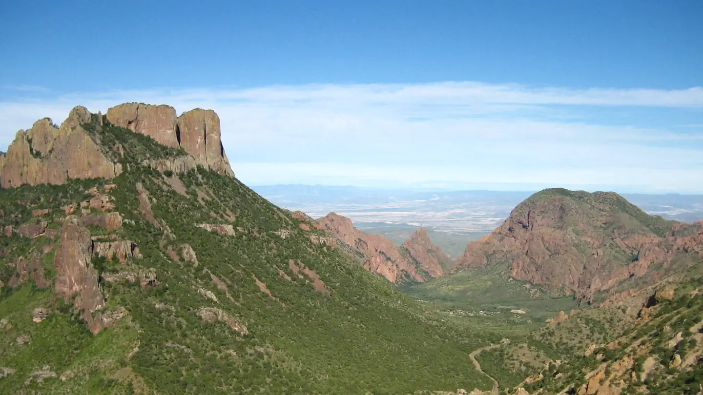
Chisos Basin Campground, perched high in the rugged Chisos Mountains, is the most sought-after campground in Big Bend National Park. At an altitude of 5,400 ft. (1646 m), the campground is surrounded on all sides by tall, rocky cliffs and is conveniently located near some of the park's most spectacular and popular trails. This campground offers excellent views and mild temperatures.
Also found in the Chisos Basin area is the Chisos Basin Visitor Center, the General Store and the Chisos Mountains Lodge, which houses the only restaurant in Big Bend National Park.
Important: The road to the campground is steep and winding with sharp hairpin turns. Trailers over 19 feet and RVs over 24 feet are not recommended, and will not be accommodated. No RV parking is available at the group campground, nor is generator use allowed. All sites where you may have a generator are now reservable. If you need to use a generator and you do not have a reservation in a site that will allow generator use, you will need to camp elsewhere.
Note: Campsites are small, rocky, and not level, so there are very few sites truly suitable for RVs. Many sites will allow an RV/Trailer/Van/Camper, but you will not be able to get level. The campground is almost always full, and if the site you booked doesn’t work, in all likelihood you will NOT be able to switch sites, and will either have to make your site work, or find accommodations at another campground. It is necessary that you carry some form of leveling blocks/devices with you. Please carefully review the site details before making a reservation.
Recreation
This campground is a hub for hikers. Some of the park's most spectacular and popular Day Hike trails are nearby, including the Lost Mine Trail, the Window Trail, the South Rim Trail and the Pinnacles Trail, with its access to the park's highest point, Emory Peak (elevation 7,825 ft./2385 m). Campers can find the trailheads for most of these trails in the main Chisos Basin area a mile or so further down the basin road from the campground.
Access to the river is approximately 30 miles (48 km) away, where visitors can canoe, kayak and fish.
Facilities
The Chisos Basin Campground has 60 individual campsites. The campground is reservable year-round, some sites six months in advance, some two weeks in advance (Sites 8 - 10, 12 - 15, 31, 37 (accessible), and 48 - 60. There is no first-come, first served camping. A few sites are set aside for administrative use.
Because of the size of each campsite, they are more suitable to tent camping than RVs or trailers, though both are allowed at some campsites. Each site comes with a picnic table, charcoal grill and bear-proof food storage container, and some sites come with picnic shelters for shade. Sites are generally rocky and not level. Most campsites are within easy walking distance to drinking water and toilets, and a dump station is provided for RVs and trailers.
The dump station is oddly situated and requires EXTRA long hoses, as it's on the right side of the road, opposite from most RV sewer outlets. Another more easily utilized dump station is located at Rio Grande Village.
Natural Features
The national park is named for a curve in the Rio Grande called the "big bend." For 1,250 miles (2012 km), the river is an International Boundary between the United States and Mexico.
The campground lies at the base of several sloping cliffs amidst montane shrubland; desert plants such as Arizona cyprus and mesquite trees fill the landscape. Maple, aspen, pinyon and ponderosa pines grow at higher elevations just above the campground. Though it is lower than the surrounding cliffs, the Chisos Basin is at a higher elevation than other campgrounds within the park. Summer temperatures here are cool, yet warmer than other areas in fall and winter due to the cold air sinking into lower regions.
The Chisos Mountains are a popular nesting site for migratory birds. The mountains provide the only nesting ground in the United States for the Colima warbler, which arrives in mid-April and departs for its wintering grounds in southwestern Mexico by mid-September.
Nearby Attractions
Big Bend National Park encompasses 801,000 acres (324,153 ha) and the Chisos Basin area is centrally located. This allows visitors an excellent opportunity to explore all areas of the park in a relatively short drive. Big Bend offers excellent hiking trails, miles of rugged dirt roads, and endless possibilities for sightseeing.
The facts
- 56 bookable sites
- 62 sites in total, including non-bookable
- 1 accessible site
- Vehicles up to 24 ft
- Up to 8 people per site
- Loops: CHISOS BASIN (BIG BEND), Loop 1, Loop 2, Loop 3
Site types
- 56 Standard Nonelectric
- 6 Management
Amenities
- Picnic tables
- Shade
- Pets allowed
- Water hookups — not available
- Campfires allowed — not available
Not recorded upstream: electric hookups, sewer hookups, fire pits, grills.
62 campsites at Chisos Basin Campground (Big Bend, TX)
Check-in 1:00 PM · Check-out 12:00 PM
| Site | Loop | Type | Entry | Surface | Grade | Access | Max rig | People | |
|---|---|---|---|---|---|---|---|---|---|
| HOST-1 | CHISOS BASIN (BIG BEND) | Management | Pull Through | Paved | — | Drive In | 24 ft | 8 | 🐾 |
| HOST-2 | CHISOS BASIN (BIG BEND) | Management | Pull Through | Paved | — | Drive In | 24 ft | 8 | 🐾 |
| 001 | Loop 1 | Standard Nonelectric | Back In | Paved | Severe | Drive In | 20 ft | 8 | 🐾 |
| 002 | Loop 1 | Standard Nonelectric | Back In | Paved | — | Drive In | 23 ft | 8 | 🐾 |
| 003 | Loop 1 | Standard Nonelectric | Parallel | Paved | Severe | Drive In | 24 ft | 8 | 🐾 |
| 004 | Loop 1 | Standard Nonelectric | Parallel | Paved | — | Drive In | 24 ft | 8 | 🐾 |
| 005 | Loop 1 | Standard Nonelectric | Parallel | Paved | — | Drive In | 24 ft | 8 | 🐾 |
| 006 | Loop 1 | Standard Nonelectric | Pull Through | Paved | — | Drive In | 24 ft | 8 | 🐾 |
| 007 | Loop 1 | Standard Nonelectric | Pull Through | Paved | — | Drive In | 24 ft | 8 | 🐾 |
| 008 | Loop 1 | Standard Nonelectric | Parallel | Gravel | Moderate | Drive In | 15 ft | 8 | 🐾 |
| 009 | Loop 1 | Standard Nonelectric | Back In | Paved | — | Drive In | 24 ft | 8 | 🐾 |
| 010 | Loop 1 | Standard Nonelectric | Parallel | Gravel | Severe | Drive In | 20 ft | 8 | 🐾 |
| 011 | Loop 1 | Management | Back In | Paved | Moderate | Drive In | 20 ft | 8 | 🐾 |
| 012 | Loop 1 | Standard Nonelectric | Back In | Paved | Moderate | Drive In | 20 ft | 8 | 🐾 |
| 013 | Loop 1 | Standard Nonelectric | Back In | Paved | Moderate | Drive In | 24 ft | 8 | 🐾 |
| 014 | Loop 1 | Standard Nonelectric | Back In | Paved | — | Drive In | 24 ft | 8 | 🐾 |
| 015 | Loop 1 | Standard Nonelectric | Back In | Paved | — | Drive In | 24 ft | 8 | 🐾 |
| 016 | Loop 1 | Standard Nonelectric | Back In | Paved | — | — | 24 ft | 8 | 🐾 |
| 017 | Loop 1 | Standard Nonelectric | Back In | Paved | — | Drive In | 24 ft | 8 | 🐾 |
| 018 | Loop 1 | Standard Nonelectric | Back In | Paved | — | Drive In | 24 ft | 8 | 🐾 |
| 019 | Loop 1 | Standard Nonelectric | Parallel | Paved | — | Drive In | 20 ft | 8 | 🐾 |
| 020 | Loop 1 | Standard Nonelectric | Parallel | Paved | — | Drive In | 20 ft | 8 | 🐾 |
| 021 | Loop 2 | Standard Nonelectric | Back In | Paved | Severe | Drive In | 20 ft | 8 | 🐾 |
| 022 | Loop 2 | Management | Parallel | Paved | — | Drive In | 15 ft | 8 | 🐾 |
| 023 | Loop 2 | Standard Nonelectric | Parallel | Paved | Slight | Drive In | 20 ft | 8 | 🐾 |
| 024 | Loop 2 | Standard Nonelectric | Parallel | Paved | — | Drive In | 20 ft | 8 | 🐾 |
| 025 | Loop 2 | Standard Nonelectric | Parallel | Paved | — | Drive In | 24 ft | 8 | 🐾 |
| 026 | Loop 2 | Standard Nonelectric | Parallel | Paved | — | Drive In | 24 ft | 8 | 🐾 |
| 027 | Loop 2 | Standard Nonelectric | Back In | Paved | Slight | Drive In | 20 ft | 8 | 🐾 |
| 028 | Loop 2 | Standard Nonelectric | Back In | Paved | — | Drive In | 20 ft | 8 | 🐾 |
| 029 | Loop 2 | Standard Nonelectric | Parallel | Paved | Slight | Drive In | 20 ft | 8 | 🐾 |
| 030 | Loop 2 | Standard Nonelectric | Back In | Paved | — | Drive In | 22 ft | 8 | 🐾 |
| 031 | Loop 2 | Standard Nonelectric | Parallel | Paved | Severe | Drive In | 20 ft | 8 | 🐾 |
| 032 | Loop 2 | Standard Nonelectric | Back In | Paved | Moderate | Drive In | 20 ft | 8 | 🐾 |
| 033 | Loop 2 | Standard Nonelectric | Back In | Paved | Moderate | Drive In | 20 ft | 8 | 🐾 |
| 034 | Loop 2 | Standard Nonelectric | Back In | Paved | Moderate | Drive In | 20 ft | 8 | 🐾 |
| 035 | Loop 2 | Standard Nonelectric | Back In | Paved | — | — | 20 ft | 8 | 🐾 |
| 036 | Loop 2 | Standard Nonelectric | Parallel | Paved | — | Drive In | 24 ft | 8 | 🐾 |
| 037 - ADA Only | Loop 2 | Standard Nonelectric | Pull Through | Paved | — | Drive In | 24 ft | 8 | ♿ 🐾 |
| 038 | Loop 2 | Standard Nonelectric | Parallel | Paved | — | Drive In | 22 ft | 8 | 🐾 |
| 039 | Loop 2 | Standard Nonelectric | Parallel | Paved | — | Drive In | 20 ft | 8 | 🐾 |
| 040 | Loop 2 | Standard Nonelectric | Parallel | Paved | Moderate | Drive In | 17 ft | 8 | 🐾 |
| 041 | Loop 3 | Standard Nonelectric | Parallel | Paved | Moderate | Drive In | 20 ft | 8 | 🐾 |
| 042 | Loop 3 | Standard Nonelectric | Parallel | Paved | — | Drive In | 20 ft | 8 | 🐾 |
| 043 | Loop 3 | Standard Nonelectric | Parallel | Paved | — | Drive In | 19 ft | 8 | 🐾 |
| 044 | Loop 3 | Standard Nonelectric | Parallel | Paved | — | Drive In | 22 ft | 8 | 🐾 |
| 045 | Loop 3 | Standard Nonelectric | Back In | Paved | Severe | Drive In | 23 ft | 8 | 🐾 |
| 046 | Loop 3 | Management | Back In | Paved | — | Drive In | 23 ft | 8 | 🐾 |
| 047 | Loop 3 | Management | Back In | Paved | Slight | Drive In | 24 ft | 8 | 🐾 |
| 048 | Loop 3 | Standard Nonelectric | Parallel | Paved | Moderate | Drive In | 20 ft | 8 | 🐾 |
| 049 | Loop 3 | Standard Nonelectric | — | Paved | Severe | Hike In | 19 ft | 4 | 🐾 |
| 050 | Loop 3 | Standard Nonelectric | Parallel | Paved | Slight | Drive In | 20 ft | 8 | 🐾 |
| 051 | Loop 3 | Standard Nonelectric | Back In | Paved | Severe | Drive In | 20 ft | 8 | 🐾 |
| 052 | Loop 3 | Standard Nonelectric | Back In | Paved | Moderate | Drive In | 24 ft | 8 | 🐾 |
| 053 | Loop 3 | Standard Nonelectric | Parallel | Paved | Slight | Drive In | 22 ft | 8 | 🐾 |
| 054 | Loop 3 | Standard Nonelectric | Parallel | Paved | — | Drive In | 24 ft | 8 | 🐾 |
| 055 | Loop 3 | Standard Nonelectric | Parallel | Paved | — | Hike In | 19 ft | 8 | 🐾 |
| 056 | Loop 3 | Standard Nonelectric | Parallel | Paved | — | Hike In | 19 ft | 8 | 🐾 |
| 057 | Loop 3 | Standard Nonelectric | Parallel | Paved | Severe | Drive In | 19 ft | 8 | 🐾 |
| 058 | Loop 3 | Standard Nonelectric | Back In | Paved | — | Drive In | 24 ft | 8 | 🐾 |
| 059 | Loop 3 | Standard Nonelectric | Parallel | Paved | Severe | Drive In | 19 ft | 8 | 🐾 |
| 060 | Loop 3 | Standard Nonelectric | Parallel | Paved | Slight | Drive In | 19 ft | 8 | 🐾 |
Getting there
From Interstate 10, take highway 385 south to Fort Stockton and then on to Marathon. From Marathon, go 40 miles (64 km) south on Highway 385 to the north entrance of Big Bend National Park. Drive straight 26 miles (42 km) to Park Headquarters at Panther Junction. Turn right and drive for three miles (1 km). Turn left at the Basin sign and go seven miles (2.1 km) before making a right into the campground road.
29.27500, -103.30417 · 29°16'30.0"N 103°18'15.0"W
Typical weather
Typically 87°F in Jun, down to 58°F in Jan.
| Jan | Feb | Mar | Apr | May | Jun | Jul | Aug | Sep | Oct | Nov | Dec | |
|---|---|---|---|---|---|---|---|---|---|---|---|---|
| High °F | 58 | 63 | 69 | 76 | 83 | 87 | 85 | 84 | 79 | 74 | 65 | 59 |
| Low °F | 38 | 41 | 46 | 52 | 60 | 65 | 65 | 65 | 60 | 54 | 45 | 39 |
| Precip in | 0.6 | 0.6 | 0.5 | 0.6 | 1.6 | 2.7 | 3.6 | 3.1 | 2.7 | 1.3 | 0.6 | 0.5 |
1991–2020 averages from the nearest NOAA station, 0.4 mi away — not measured at the facility itself, and elevation can make a real difference over that distance.
Map
Fees and stay limits
Entrance Fee. Big Bend charges an entrance fee separate from the camping fee. You may pay the fee upon arrival or purchase in advance. The park also honors Federal interagency passes (e.g., annual, senior, military, access, 4th grade, Golden Age pass etc.). For more information visit the park's Fees & Passes web page.
From Recreation.gov, which is not always current. The operator's own page is the authority on what you will be charged.
More photos
Member photos
Common questions about Chisos Basin Campground (Big Bend, TX)
- Can you reserve a site at Chisos Basin Campground (Big Bend, TX)?
- Yes, Chisos Basin Campground (Big Bend, TX) is reservable through Recreation.gov.
- How many campsites does Chisos Basin Campground (Big Bend, TX) have?
- 62 sites in total, of which 56 can be booked.
- What is the maximum RV length at Chisos Basin Campground (Big Bend, TX)?
- 24 ft. That is the longest vehicle the sites here are recorded as taking; individual sites may be shorter.
- Are pets allowed at Chisos Basin Campground (Big Bend, TX)?
- Yes, pets are allowed at Chisos Basin Campground (Big Bend, TX).
- Does Chisos Basin Campground (Big Bend, TX) have hookups?
- No hookups are recorded here.
- Are campfires allowed at Chisos Basin Campground (Big Bend, TX)?
- Campfires are not allowed at Chisos Basin Campground (Big Bend, TX).
Camping near Chisos Basin Campground (Big Bend, TX)
- Chisos Basin Group Campground (Big Bend, TX) less than 0.1 mi · Campground · we watch it
- Big Bend Backcountry Camping 7 mi · Campground · we watch it
- Cottonwood (Big Bend, TX) 16.2 mi · Campground · we watch it
- Rio Grande Village (Big Bend, TX) 21.9 mi · Campground · we watch it
- Rio Grande Village Group Campground (Big Bend, TX) 21.9 mi · Campground · we watch it
- Chisos Basin Visitor Center 0.4 mi · Facility
- Panther Junction Visitor Center 7 mi · Facility
- Castolon Visitor Center 16 mi · Facility
- Rio Grande Village RV 21.5 mi · Facility
- Rio Grande Village Visitor Center 21.5 mi · Visitor Center
- Rio Grande Village Visitor Center 21.5 mi · Visitor Center
- Persimmon Gap Visitor Center 27.7 mi · Facility
Contact
- Phone 432-477-1121
- Book Recreation.gov
Recreation.gov last updated this record on 2026-02-25.
Facility information and photographs from Recreation.gov (RIDB). SpotOpened is not affiliated with Recreation.gov or any federal agency.
Comments