Congaree Picnic Shelter
Campground · South Carolina · 2 bookable sites ·
Managed by the National Park Service
Congaree National Park Wilderness Area (Wilderness Area) · Restricted Access
- 2
- Bookable sites
- 2
- Accessible sites
- 116 ft
- Elevation

Overview
The Congaree Picnic Shelter is located a short distance from the Harry Hampton Visitor Center and is adjacent to the park's primary parking area. The picnic shelter is also near the park's popular Boardwalk Trail.
Recreation
Congaree National Park offers a wide range of opportunities to explore and experience the great outdoors. Many miles of hiking trails can be found in the park ranging from easy to moderately strenuous. Old growth forests, teeming with wildlife can be accessed by park trails or by exploring the many miles of waterways in a canoe or kayak. Interpretive programs including guided hikes, canoe tours and special ranger-led programs are offered throughout the year.
Facilities
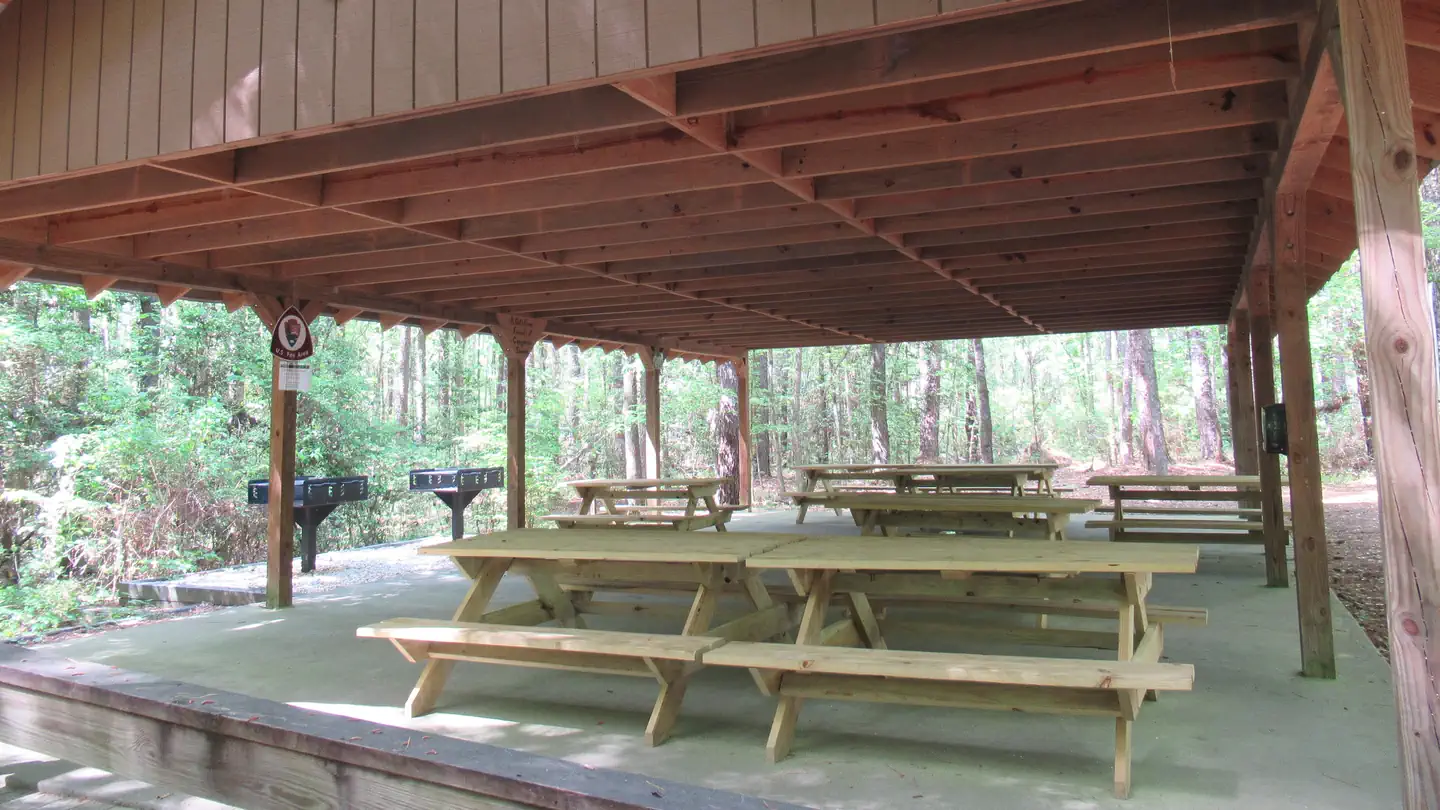
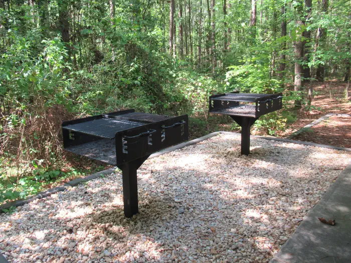
The picnic shelter offers picnic tables and two large barbeque grills, as well as trash and recycling cans.
Natural Features
The picnic shelter is located in an upland pine forest. The shelter is a short walk away from the Boardwalk Trail, which takes visitors into the old-growth floodplain forest that Congaree is most notable for, as well as access to other trails that take visitors into the park's backcountry where they can see champion-sized trees and wildlife. The shelter is also close to trails that take visitors through the upland pine forest where they can see how fire is a natural part of the ecosystem and is used to maintain and restore this fire-dependent habitat.
Nearby Attractions
Congaree National Park is located near many attractions including state parks, forests and parks. The city of Columbia is a short drive from the park and offers access to many attractions including museums, city parks and shopping.
Charges & Cancellations
Customers who cancel a picnic shelter reservation less than seven (7) days before the arrival date will forfeit the total fee.
The facts
- 2 bookable sites
- 2 sites for day use only
- 2 accessible sites
Site types
- 2 Group Picnic Area
Amenities
- Picnic tables
- Grills
- Shade
- Pets allowed
- Water hookups — not available
- Campfires allowed — not available
Not recorded upstream: electric hookups, sewer hookups, fire pits.
2 campsites at Congaree Picnic Shelter
Check-in 01:00 PM · Check-out 05:00 PM
| Site | Loop | Type | Entry | Surface | Max rig | People | |
|---|---|---|---|---|---|---|---|
| Congaree Picnic Shelter 1:00 PM to 5:00 PM | — | Group Picnic Area | — | — | — | — | ♿ 🐾 |
| Congaree Picnic Shelter 9:00 AM to 1:00 PM | — | Group Picnic Area | — | — | — | — | ♿ |
Getting there
From Spartanburg - Follow Interstate 26 east towards Charleston for 92 miles and then take Exit 116 for Interstate 77 north towards Charlotte (on the left). Follow Interstate 77 for approximately five miles to Exit 5, Bluff Road. Follow directions below from I 77, Exit 5. (Approximate travel time: 2 hours)
From Charleston - Follow Interstate 26 west (towards Columbia) for approximately 75 miles. Take Exit 145, US 601 north towards St. Matthews. Follow US 601 for 23 miles. Turn left onto Route 48 (Bluff Road) and follow for 11 miles to Mt. View Road. Turn left and follow Mt. View Road to Old Bluff Road. Turn right on Old Bluff Road for half a mile to the park entrance, which will be on your left. (Approximate travel time: 2 hours)
From Charlotte - Take Interstate 77 south towards Columbia for approximately 95 miles to Exit 5, Bluff Road. Follow directions below from Interstate 77, Exit 5. (Approximate travel time: 2 hours)
From Augusta, GA - Follow Interstate 20 east towards Columbia for 65 miles to Exit 64B. Merge onto Interstate 26 and follow for 8 miles to Exit 116, Interstate 77 north towards Charlotte (on the left). Follow Interstate 77 for 5 miles to Exit 5, Bluff Road. Follow directions below from Interstate 77, Exit 5. (Approximate travel time: 1 hour 45 minutes)
From Interstate 77, Exit 5 At Exit 5 turn onto SC Hwy 48 East/Bluff Road - Following the brown and white "Congaree National Park" directional signs, travel approximately 8 miles on and then take a slight right onto Old Bluff Road. Follow Old Bluff Road for 4.5 miles to the park entrance sign, which will be on the right. Proceed one mile to the Harry Hampton Visitor Center. Parking lots will be on the right.
33.83039, -80.82361 · 33°49'49.4"N 80°49'25.0"W
Typical weather
| Jan | Feb | Mar | Apr | May | Jun | Jul | Aug | Sep | Oct | Nov | Dec | |
|---|---|---|---|---|---|---|---|---|---|---|---|---|
| High °F | — | — | — | — | — | — | — | — | — | — | — | — |
| Low °F | — | — | — | — | — | — | — | — | — | — | — | — |
| Precip in | 3.8 | 3.7 | 4.0 | 3.3 | 3.7 | 5.1 | 5.0 | 4.6 | 4.7 | 3.5 | 3.0 | 3.9 |
1991–2020 averages from the nearest NOAA station, 9 mi away — not measured at the facility itself, and elevation can make a real difference over that distance.
Map
Fees and stay limits
The Congaree Picnic Shelter may be rented for up to four hours for $25 (9:00 AM to 1:00 PM or 1:00 PM to 5:00 PM). If you wish to rent the shelter for the entire day (9:00 AM to 5:00 PM), then you will need to make two reservations (one for each time slot) for a total of $50.
From Recreation.gov, which is not always current. The operator's own page is the authority on what you will be charged.
More photos
Member photos
Common questions about Congaree Picnic Shelter
- Can you reserve a site at Congaree Picnic Shelter?
- Yes, Congaree Picnic Shelter is reservable through Recreation.gov.
- How many campsites does Congaree Picnic Shelter have?
- 2 sites.
- Are pets allowed at Congaree Picnic Shelter?
- Yes, pets are allowed at Congaree Picnic Shelter.
- Does Congaree Picnic Shelter have hookups?
- No hookups are recorded here.
- Are campfires allowed at Congaree Picnic Shelter?
- Campfires are not allowed at Congaree Picnic Shelter.
Camping near Congaree Picnic Shelter
- Congaree National Park Ranger-Guided Canoe Tours 0.1 mi · Tickets · we watch it
- Congaree National Park Firefly Viewing Lottery 0.1 mi · Tickets · we watch it
- Longleaf Campground 0.5 mi · Campground · we watch it
- Bluff Hike In Camping 0.5 mi · Campground · we watch it
- Rocky Branch Seasonal Campground (SC) 50.8 mi · Campground · we watch it
- Collins Creek Seasonal Campground (SC) 59.8 mi · Campground · we watch it
- Harry Hampton Visitor Center 0.1 mi · Visitor Center
- Orangeburg National Fish Hatchery 24.1 mi · Facility
- Molly's Rock Picnic Area 56.4 mi · Facility
- Enoree Ranger District 59.3 mi · Facility
Contact
- Phone 803.776.4396
- Email cong_information@nps.gov
- Book Recreation.gov
Recreation.gov last updated this record on 2026-03-11.
Facility information and photographs from Recreation.gov (RIDB). SpotOpened is not affiliated with Recreation.gov or any federal agency.
Comments