Timpanogas
Campground · Oregon · 1 bookable site ·
Managed by the USDA Forest Service
Willamette National Forest (NF) · Open Access
- 1
- Bookable site
- up to 6
- People per site
- 5,322 ft
- Elevation
Overview
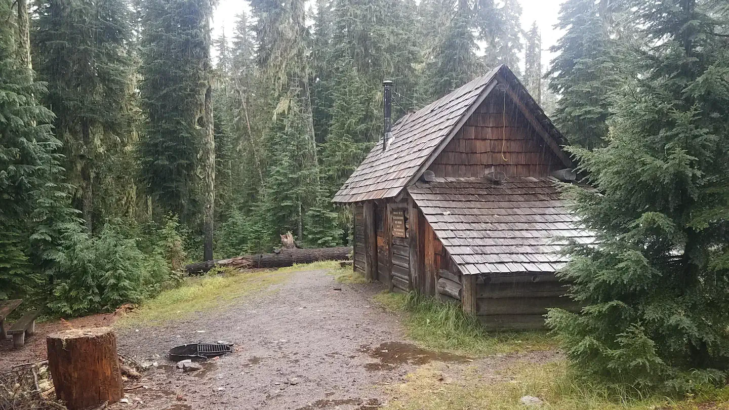
Timpanogas Shelter sits on shore of its namesake lake at an altitude of 5,300 feet in the Willamette National Forest within the Oregon Cascades Recreation Area. The cabin was patterned after the old Civilian Conservation Corps 3-sided shelter and was built in 1991 with the help of a University of Oregon outdoor school class and the Walker Rim Snowmobile Club.The cabin is typically open from late June through late October. It is accessible by car, but the last 7 miles of the road are rough and narrow.
Recreation
Anglers enjoy fishing for brook trout and cutthroat on upper and lower Timpanogas Lakes, even though the lakes are closed to motorcraft. Canoeing is also possible on the lakes.Those not inclined to fish can enjoy hiking or mountain biking on numerous trails in the Timpanogas area, especially in late August when huckleberries are ripe for picking. This includes the Timpanogas Lake Trail, which starts at the Timpanogas Campground.
The Diamond Peak Trail Area, Pacific Crest Trail and Diamond Peak Wilderness are also nearby.
Facilities
This rustic 15 x 18 shelter with a dirt floor is designed to accommodate 6-8 people and comes equipped with a sleeping loft, a table with benches and a wood stove for heat. A picnic table, campfire ring and pit toilet are located outside. Additional camping is available on-site for up to 20 people. Drinking water, firewood and electricity are not provided. The cabin does not have a cook stove or cooking supplies. Potable water is available from a hand pump at the nearby Timpanogas Campground until late September. Items such as bedding, lanterns or flashlights, matches, extra toilet paper, first aid supplies, trash bags, dish soap, towels and an ice chest are not available. Insect repellent is highly recommended. Guests are expected to pack out their trash and clean the cabin before leaving.Natural Features
The cabin is situated in a mountainous and heavily forested area where it is possible to see Diamond Peak, Sawtooth and Cowhorn Mountains. Timpanogas Lake is just one of several alpine lakes in the area.Willamette National Forest offers prime habitat for such species as Roosevelt elk, black bear, northern bald eagles, mule deer and bobcats, among other wildlife.
Nearby Attractions
Trails for hiking and mountain biking are located less than a mile from the shelter.The facts
- Season: June – Late October, weather dependent — USDA Forest Service, Aug 24, 2026
- 1 bookable site
- 3 sites in total, including non-bookable
- Up to 6 people per site
- Loops: AREA TIMPANOGAS, S&P
Site types
- 2 Management
- 1 Cabin Nonelectric
3 campsites at Timpanogas
| Site | Loop | Type | Entry | Surface | Max rig | People | |
|---|---|---|---|---|---|---|---|
| CABIN1 | AREA TIMPANOGAS | Cabin Nonelectric | — | — | — | 6 | |
| Extra Vehicle | S&P | Management | — | — | — | 6 | |
| Timpanogas CG | S&P | Management | — | — | — | 6 |
Getting there
From I-5, take Exit 188A onto Highway 58 and proceed just past MP 37 (east of Oakridge), turning right onto Kitson Springs Road. Proceed 0.5 mile to junction with Forest Service Road (FSR) 21, also signed as Diamond Drive. Turn right onto FSR 21 and continue approximately 32 miles, turning left onto paved FSR 2154. Continue on FSR 2154 approximately 10 miles (pavement ends at the 3.4 MP). At the 2154-6010 junction, stay on the 2154 (right); continue to stay on the 2154. At the next junction of the 2154-372 stay (right). Continue for a short distance. Watch for a gate on the left side of an unmarked spur, just after a switchback. If you reach the road into the Timpanogas campground, you've driven too far.
43.41391, -122.11338 · 43°24'50.1"N 122°6'48.2"W
Typical weather
| Jan | Feb | Mar | Apr | May | Jun | Jul | Aug | Sep | Oct | Nov | Dec | |
|---|---|---|---|---|---|---|---|---|---|---|---|---|
| High °F | — | — | — | — | — | — | — | — | — | — | — | — |
| Low °F | — | — | — | — | — | — | — | — | — | — | — | — |
| Precip in | 10.1 | 7.6 | 8.4 | 7.2 | 4.7 | 2.9 | 0.8 | 0.8 | 2.0 | 5.4 | 9.8 | 11.9 |
1991–2020 averages from the nearest NOAA station, 2.8 mi away — not measured at the facility itself, and elevation can make a real difference over that distance.
Map
More photos
Member photos
Common questions about Timpanogas
- Can you reserve a site at Timpanogas?
- Yes, Timpanogas is reservable through Recreation.gov.
- How many campsites does Timpanogas have?
- 3 sites in total, of which 1 can be booked.
Also listed by
Timpanogas also appears in other federal recreation data. Facts below are matched by name and location, not confirmed by Timpanogas's operator.
USDA Forest Service — data as of Aug 24, 2026
- Single Campsites - $14 per night
- Extra Vehicles - $6 per vehicle, per night
Restrictions:
- Camping is not allowed more than 14 days in a 60 day period.
- Check-in time: 2:00 pm or later. Check-out time: 1:00 pm
- Use of chainsaws in the campground is prohibited
- Dogs MUST be on leash at all times within the campground
Camping near Timpanogas
- Windy Group Camp 5.3 mi · Campground · we watch it
- Whitefish Horse Camp 5.4 mi · Campground · we watch it
- Spring 5.9 mi · Campground · we watch it
- Contorta Point Group Camp 6.2 mi · Campground · we watch it
- Contorta Flat Campground 6.6 mi · Campground · we watch it
- Kelsay Valley Horse Camp 6.7 mi · Campground · we watch it
- Inlet Campground 7.4 mi · Campground · we watch it
- Bunker Hill Campground 7.5 mi · Campground · we watch it
- East Lemolo Campground 7.5 mi · Campground · we watch it
- Tandy Bay Picnic Area 5.4 mi · Facility
- Lemolo Lake/Crater Lake N KOA 7.8 mi · Campground
- Poole Creek Swimming Site 8.1 mi · Facility
Contact
- Phone 541-782-2283
- Book Recreation.gov
Recreation.gov last updated this record on 2026-02-25.
Facility information and photographs from Recreation.gov (RIDB). SpotOpened is not affiliated with Recreation.gov or any federal agency.
Comments