Scaredman Recreation Site
Campground · Oregon · 10 bookable sites ·
Managed by the Bureau of Land Management
Roseburg District Swiftwater Field Office (Bureau of Land Management OR) · Open Access
- 10
- Bookable sites
- up to 8
- People per site
- 1,375 ft
- Elevation
Overview
Reservations must be made 5 days prior to arrival.
Disregard the "FF" (First-Come-First-Serve) availability. We do not allow on-site transactions.
Drinking water is currently unavailable from spigots within the campground.
Off the beaten path, this minimally developed campground along Canton Creek features riverside picnic sites, drinking water spigots, and a vault restroom facility. Nearby, there are several outstanding undeveloped swimming holes along both Canton and Steamboat Creeks. Canton Creek and Steamboat Creek are closed to all angling. Just 3 miles downstream from Scaredman, the North Umpqua River offers world-class fly-fishing.
Recreation
Picnicing, relaxing, and swimming are the primary recreation activites taking place at Cavitt Creek Recreation Site.
Fishing and whitewater rafting activites can take place just 3 miles downstream on the North Umpqua River.
Facilities
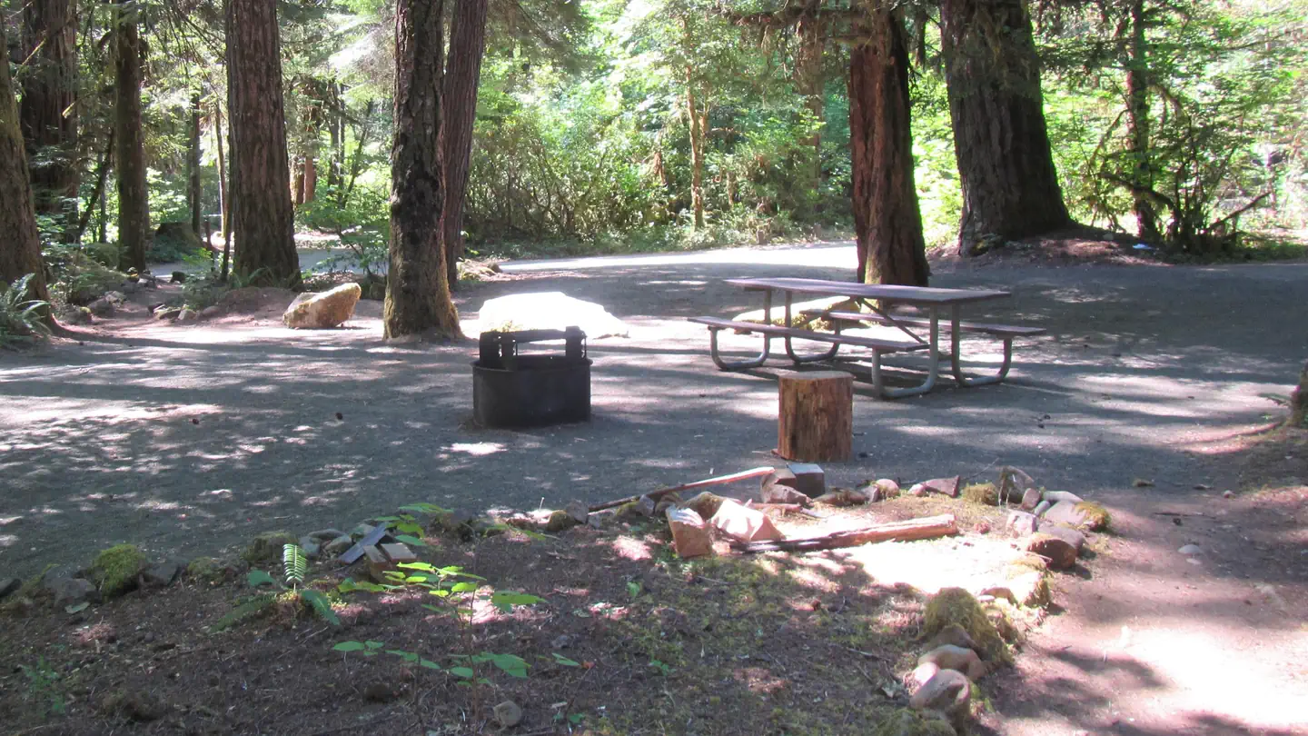
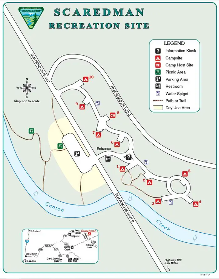
Scaredman has 10 campsites with tables and fire rings. Drinking water is currently unavailable from spigots within the campground. A vault toilet on site. Campers will also have access to the riverside day-use area.
Natural Features
The recreation site is remote in heavily wooded area of different species. The campground and day-use area are at 1390' along a creek and many waterfalls, rivers, and forests are in the surrounding region.
Nearby Attractions
Within a short drive from the campground you can have opportunities for day of rafting on the North Umpqua, fishing, hiking, viewing waterfalls, or driving along the Rogue - Umpqua National Scenic Byway. Just 3 miles downstream from Canton Creek is Steamboat Creek, a short tributary of the North Umpqua River, that can provide many opportunites for swimming.
The facts
- 10 bookable sites
- Up to 8 people per site
- Loops: Northern, Southern
Site types
- 10 Standard Nonelectric
Amenities
- Campfires allowed
- Shade
- Pets allowed
Not recorded upstream: electric hookups, water hookups, sewer hookups, fire pits, picnic tables, grills.
10 campsites at Scaredman Recreation Site
Check-in 01:00 PM · Check-out 11:00 AM
| Site | Loop | Type | Entry | Surface | Access | Water | Max rig | People | |
|---|---|---|---|---|---|---|---|---|---|
| Site 006 | Northern | Standard Nonelectric | Back In | — | — | — | — | 8 | 🐾 |
| Site 007 | Northern | Standard Nonelectric | Back In | — | — | — | — | 8 | 🐾 |
| Site 008 | Northern | Standard Nonelectric | Back In | — | — | — | — | 8 | 🐾 |
| Site 009 | Northern | Standard Nonelectric | Back In | — | — | — | — | 8 | 🐾 |
| Site 010 | Northern | Standard Nonelectric | Back In | — | — | — | — | 8 | 🐾 |
| Site 001 | Southern | Standard Nonelectric | Back In | — | — | Riverfront | — | 8 | 🐾 |
| Site 002 | Southern | Standard Nonelectric | Parallel | — | Hike In | Riverfront | — | 8 | 🐾 |
| Site 003 | Southern | Standard Nonelectric | Back In | — | — | Riverfront | — | 8 | 🐾 |
| Site 004 | Southern | Standard Nonelectric | Back In | — | — | Riverfront | — | 8 | 🐾 |
| Site 005 | Southern | Standard Nonelectric | Parallel | — | Hike In | — | — | 8 | 🐾 |
Getting there
From Roseburg, travel east on Highway 138 for 40 miles. Turn left/north onto Steamboat Creek Road and then after a half mile, turn left/north onto Canton Creek Road. Scaredman is three miles from the Steamboat Creek/Canton Creek junction. Elevation: 1390’
43.37987, -122.76139 · 43°22'47.5"N 122°45'41.0"W
Typical weather
| Jan | Feb | Mar | Apr | May | Jun | Jul | Aug | Sep | Oct | Nov | Dec | |
|---|---|---|---|---|---|---|---|---|---|---|---|---|
| High °F | — | — | — | — | — | — | — | — | — | — | — | — |
| Low °F | — | — | — | — | — | — | — | — | — | — | — | — |
| Precip in | 7.5 | 5.5 | 6.4 | 5.3 | 3.5 | 1.8 | 0.5 | 0.5 | 1.5 | 4.4 | 8.4 | 10.9 |
1991–2020 averages from the nearest NOAA station, 10.2 mi away — not measured at the facility itself, and elevation can make a real difference over that distance.
Map
More photos

Member photos
Common questions about Scaredman Recreation Site
- Can you reserve a site at Scaredman Recreation Site?
- Yes, Scaredman Recreation Site is reservable through Recreation.gov.
- How many campsites does Scaredman Recreation Site have?
- 10 sites.
- Are pets allowed at Scaredman Recreation Site?
- Yes, pets are allowed at Scaredman Recreation Site.
- Are campfires allowed at Scaredman Recreation Site?
- Campfires are allowed at Scaredman Recreation Site. Check for a current fire restriction before you go.
Camping near Scaredman Recreation Site
- Canton Creek Campground 2.7 mi · Campground · we watch it
- Steamboat Ball Field Group Site 3.2 mi · Campground · we watch it
- Bogus Creek Campground 4.3 mi · Campground · we watch it
- Rock Creek Pavilion 8.4 mi · Campground · we watch it
- Susan Creek Campground 8.8 mi · Campground · we watch it
- Deer Flat Group Site (Horseshoe Bend Campground) 9.2 mi · Campground · we watch it
- Steamboat Inn 2.9 mi · Facility
- Island Campground 3.3 mi · Campground
- Steamboat Falls Campground 5.5 mi · Campground
- Apple Creek Campground 6.7 mi · Campground
- Deer Flat Group Campground 7.1 mi · Campground
- Rock Creek Recreation Site 8.5 mi · Facility
Contact
- Phone 541-440-4930
- Email BLM_OR_RB_Mail@blm.gov
- Book Recreation.gov
Recreation.gov last updated this record on 2026-06-24.
Facility information and photographs from Recreation.gov (RIDB). SpotOpened is not affiliated with Recreation.gov or any federal agency.
Comments