Fish Lake Campground - Rogue River
Campground · Oregon · 20 bookable sites ·
Managed by the USDA Forest Service
Fish Lake Recreation Area (Recreation Area) · Open Access
- 20
- Bookable sites
- 60 ft
- Max rig length
- up to 5
- People per site
- 1
- Accessible site
- 4,653 ft
- Elevation
Overview
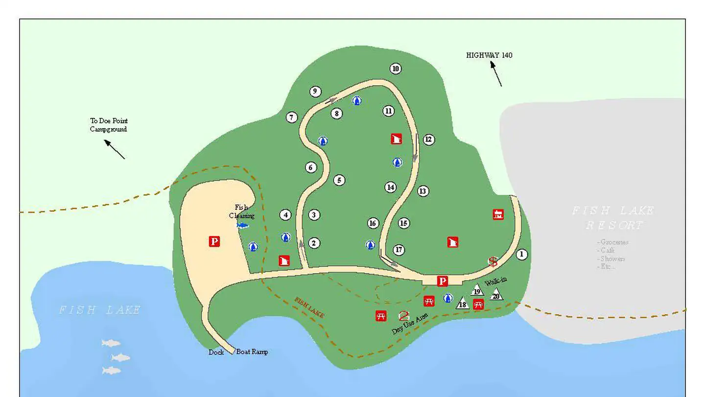
Fish Lake Campground is located 39 miles east of Medford, Oregon in the midst of an old growth forest and adjacent to Fish Lake. There are 17 campsites, that can accommodate trailers, rvs and tents and 3 sites that are tent camping only.
Fish Lake Resort is within walking distance of all campsites and provides access to a convenience store, cafe and lodging. The lake has a 10 m.p.h. speed limit and there is a boat launch within the campground and at the resort. A Historic picnic shelter is available for use with no reservations required.
Recreation
Fish Lake Campground offers biking, fishing, swimming, paddle / motor boating and hiking opportunities.
There is easy access to Fish Lake Trail, High Lakes Trail, Brown Mountain Trail and the Pacific Crest Trail. Sky Lakes Wilderness and Mount McLoughlin Trail system are less than an hour drive away.
Facilities
Drinking water and flush toilets with wash basins are provided, as well as a fish cleaning station, picnic tables and grills.
Natural Features
Fish Lake is a reservoir with 483 acres surface area and is located at 4,639 feet elevation. The lake is supplied by over 45 underground volcanic streams. The southern shore provides really good views of Mount McLoughlin and is bordered by a 2,000 year old lava flow from Brown Mountain. The northern shore accommodates 2 campgrounds and a resort.
Nearby Attractions
Campgrounds nearby include adjacent Doe Point Campground and North Fork Campground.
Lake of the Woods Resort is 8 miles east of Fish Lake Campground and provides opportunity for dining, swimming, hiking and boating.
Crater Lake National Park is 53 miles north of this campground.
Contact Info
For facility specific information, please call (541) 560-3400.The facts
- 20 bookable sites
- 22 sites in total, including non-bookable
- 1 accessible site
- Vehicles up to 60 ft
- Up to 5 people per site
- Loops: FISH LAKE CAMPGROUND - ROGUE RIVER, S&P
Site types
- 17 Standard Nonelectric
- 3 Walk To
- 2 Management
Amenities
- Campfires allowed
- Fire pits
- Picnic tables
- Grills
- Shade
- Pets allowed
Not recorded upstream: electric hookups, water hookups, sewer hookups.
22 campsites at Fish Lake Campground - Rogue River
Check-in 3:00 PM · Check-out 2:00 PM
| Site | Loop | Type | Entry | Surface | Grade | Water | Max rig | People | |
|---|---|---|---|---|---|---|---|---|---|
| 01 | FISH LAKE CAMPGROUND - ROGUE RIVER | Standard Nonelectric | Back In | — | Slight | — | 60 ft | 5 | 🐾 |
| 02 | FISH LAKE CAMPGROUND - ROGUE RIVER | Standard Nonelectric | Back In | — | Slight | — | 45 ft | 5 | 🐾 |
| 03 | FISH LAKE CAMPGROUND - ROGUE RIVER | Standard Nonelectric | Back In | — | Slight | — | 45 ft | 5 | 🐾 |
| 04 | FISH LAKE CAMPGROUND - ROGUE RIVER | Standard Nonelectric | Back In | — | Slight | — | 35 ft | 5 | 🐾 |
| 05 | FISH LAKE CAMPGROUND - ROGUE RIVER | Standard Nonelectric | Back In | — | Slight | — | 35 ft | 5 | 🐾 |
| 06 | FISH LAKE CAMPGROUND - ROGUE RIVER | Standard Nonelectric | Back In | — | Slight | — | 35 ft | 5 | 🐾 |
| 07 | FISH LAKE CAMPGROUND - ROGUE RIVER | Standard Nonelectric | Back In | — | Slight | — | 40 ft | 5 | 🐾 |
| 08 | FISH LAKE CAMPGROUND - ROGUE RIVER | Standard Nonelectric | Back In | — | Slight | — | 35 ft | 5 | 🐾 |
| 09 | FISH LAKE CAMPGROUND - ROGUE RIVER | Standard Nonelectric | Back In | — | Slight | — | 30 ft | 5 | 🐾 |
| 10 | FISH LAKE CAMPGROUND - ROGUE RIVER | Standard Nonelectric | Back In | — | Slight | — | 30 ft | 5 | 🐾 |
| 11 | FISH LAKE CAMPGROUND - ROGUE RIVER | Standard Nonelectric | Back In | — | Slight | — | 30 ft | 5 | 🐾 |
| 12 | FISH LAKE CAMPGROUND - ROGUE RIVER | Standard Nonelectric | Back In | — | Slight | — | 35 ft | 5 | ♿ 🐾 |
| 13 | FISH LAKE CAMPGROUND - ROGUE RIVER | Standard Nonelectric | Back In | — | Slight | — | 40 ft | 5 | 🐾 |
| 14 | FISH LAKE CAMPGROUND - ROGUE RIVER | Standard Nonelectric | Back In | — | Slight | — | 40 ft | 5 | 🐾 |
| 15 | FISH LAKE CAMPGROUND - ROGUE RIVER | Standard Nonelectric | Back In | — | Slight | — | 40 ft | 5 | 🐾 |
| 16 | FISH LAKE CAMPGROUND - ROGUE RIVER | Standard Nonelectric | Back In | — | Slight | — | 45 ft | 5 | 🐾 |
| 17 | FISH LAKE CAMPGROUND - ROGUE RIVER | Standard Nonelectric | Back In | — | Slight | — | 35 ft | 5 | 🐾 |
| 18 | FISH LAKE CAMPGROUND - ROGUE RIVER | Walk To | — | — | — | Lakefront | — | 5 | 🐾 |
| 19 | FISH LAKE CAMPGROUND - ROGUE RIVER | Walk To | — | — | — | Lakefront | — | 5 | 🐾 |
| 20 | FISH LAKE CAMPGROUND - ROGUE RIVER | Walk To | — | — | — | Lakefront | — | 5 | 🐾 |
| Standard S&P | S&P | Management | Back In | — | Slight | — | 60 ft | 5 | 🐾 |
| Walk In S&P | S&P | Management | — | — | — | Lakefront | — | 5 | 🐾 |
Getting there
42.39417, -122.31722 · 42°23'39.0"N 122°19'2.0"W
Typical weather
| Jan | Feb | Mar | Apr | May | Jun | Jul | Aug | Sep | Oct | Nov | Dec | |
|---|---|---|---|---|---|---|---|---|---|---|---|---|
| High °F | — | — | — | — | — | — | — | — | — | — | — | — |
| Low °F | — | — | — | — | — | — | — | — | — | — | — | — |
| Precip in | 6.1 | 4.5 | 5.3 | 5.0 | 3.7 | 1.7 | 0.5 | 0.5 | 1.3 | 3.2 | 6.0 | 7.5 |
1991–2020 averages from the nearest NOAA station, 1.9 mi away — not measured at the facility itself, and elevation can make a real difference over that distance.
Map
More photos
Member photos
Common questions about Fish Lake Campground - Rogue River
- Can you reserve a site at Fish Lake Campground - Rogue River?
- Yes, Fish Lake Campground - Rogue River is reservable through Recreation.gov.
- How many campsites does Fish Lake Campground - Rogue River have?
- 22 sites in total, of which 20 can be booked.
- What is the maximum RV length at Fish Lake Campground - Rogue River?
- 60 ft. That is the longest vehicle the sites here are recorded as taking; individual sites may be shorter.
- Are pets allowed at Fish Lake Campground - Rogue River?
- Yes, pets are allowed at Fish Lake Campground - Rogue River.
- Are campfires allowed at Fish Lake Campground - Rogue River?
- Campfires are allowed at Fish Lake Campground - Rogue River. Check for a current fire restriction before you go.
Camping near Fish Lake Campground - Rogue River
- Doe Point Campground 0.4 mi · Campground · we watch it
- North Fork Campground (Or) 2.5 mi · Campground · we watch it
- Big Elk Guard Station 3.2 mi · Campground · we watch it
- Willow Prairie Horsecamp 3.8 mi · Campground · we watch it
- Willow Prairie Cabin 3.9 mi · Campground · we watch it
- Aspen Point (Lake of the Woods, OR) 5.4 mi · Campground · we watch it
- Rainbow Bay 5.7 mi · Campground · we watch it
- Fourmile Lake Campground 6.3 mi · Campground · we watch it
- Sunset - Lake of the Woods (OR) 6.3 mi · Campground · we watch it
- Fish Lake Boating Site 0.1 mi · Facility
- Fish Lake Resort 0.2 mi · Facility
- Sunset Campground @ Lake of the Woods 6.2 mi · Campground
Contact
- Phone 541-560-3900
- Book Recreation.gov
Recreation.gov last updated this record on 2026-02-25.
Facility information and photographs from Recreation.gov (RIDB). SpotOpened is not affiliated with Recreation.gov or any federal agency.
Comments