Rob Jagger's Campground
Campground · New Mexico · 28 bookable sites ·
Managed by the Bureau of Land Management
Roswell Field Office (Bureau of Land Management NM) · Open Access
- 28
- Bookable sites
- up to 30
- People per site
- 6,216 ft
- Elevation
Overview
Rob Jaggers Camping Area:
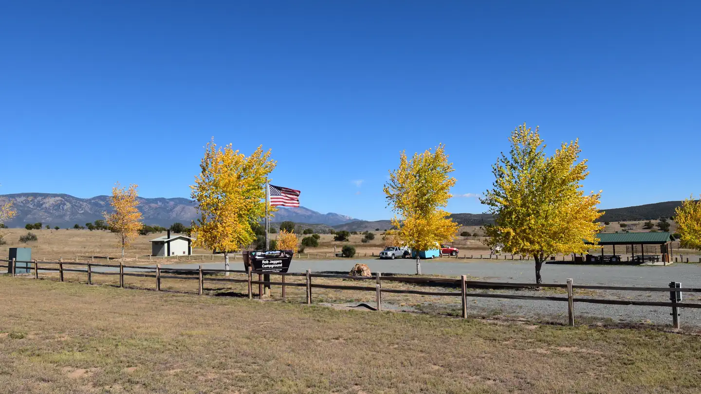
This site consists of 2 large day use parking areas, 2 vault toilets, and facilities for staging horseback riding. There are 27 campsites with electricity and potable water hookups, and other potable water outlets scattered throughout. Campites and horse corrals are first-come, first-served. Camping is restricted to the campground only and no camping is permitted in the day use parking area. Occasionally the campground is rented out for Special Recreation Permitted events. When this happens notification will be made to the public in the form of a news release. BLM requires a Special Recreation Permit for some events. Please contact the Roswell Field Office to determine if a Special Recreation Permit is required for your event. There is water and electricity located at the group shelter. To make group shelter reservations or for any other Rob Jaggers Campground information, please contact the camp host at 575-322-0030. For other information please contact the Roswell Field Office at 575-627-0272.
Recreation
RECREATION OPPORTUNITIES
This unique NCA has many opportunities for hiking, caving, horseback riding, mountain biking, camping, visiting cultural and historic sites, picnicking, hunting, wildlife viewing, nature study, and photography. There is drinking water and toilets at the Rob Jaggers Camping Area and at the Cave Campgrounds.
Trails
(Hiking, Biking, Horseback Riding) Fort Stanton NCA has 73 miles of sustainable horseback, mountain biking, and hiking trails that wind through open meadows and canyons. Trails are marked with flexible fiberglass markers with the trail name or an arrow attached to the marker. Cross-country horse and foot travel is allowed. Mountain bikes are strongly encouraged to stay on established trails to protect the rider as well as the landscape. The trails offer great views of the surrounding Sacramento and Capitan Mountains. The majority of the trails start at the Rob Jaggers Camping Area on NM 220 where you will find hitching rails, water for your animals, and a vault toilet.
Rio Bonito Petroglyph National Recreation Trail
Hike the Petroglyph Trail along the Rio Bonito and glimpse into the past. At the midpoint of the Trail, in the river bed, is Petroglyph Rock. Etched on this rock are depictions of an ancient people known as the Jornada Mogollon who have long since left the area. Very little evidence has stood the test of time, but here on the Petroglyph Trail remains a link to the culture and lifestyle of these ancient people.
The Trail can be reached from NM 220, west of the Sierra Blanca Regional Airport. Follow the highway signs stating “Upper Rio Bonito” to the bottom of the hill and turn right for approximately 250 ft then take the next left until you reach the trailhead (high-clearance vehicles are recommended). Petroglyph Rock is a short 450 ft walk from the parking area. The loop trail is approximately 2.1 miles in total length and is easy-to-moderate hiking with a few hills and areas with loose footing. Plan to spend approximately one hour on the Trail.
Historical Sites
Historic Fort Stanton is one of very few intact frontier forts in the West. Many of the original Fort buildings still stand. From 1855 to 1896, the Fort played host to some of the most colorful units and personalities of the West, including the 9th Cavalry, and the 24th, 57th, and 125th Infantry Buffalo Soldiers, Billy the Kid, Lew Wallace, Colonel Kit Carson, and General “Black Jack” Pershing. The post was also a Merchant Marine hospital & tuberculosis sanatorium, and World War II prisoner of war camp. In 1953, the Fort and 1,320 surrounding acres were transferred from Federal to State ownership, becoming a state hospital and training school until 1955. Today, the Fort area is active with other State activities and the Fort Stanton Museum is open on a daily basis (http://fortstanton.org/).
Caving
Fort Stanton Cave
With over 40 miles of mapped passages, the Cave is normally open for recreational caving under permit from April 15 to November 1. However, due to the threat of White Nose Syndrome (WNS), which has killed 8 million bats in the eastern and southern states, and has been identified nearby in Texas, the Cave has been placed in a recreational caving moratorium pending research and monitoring of the unwanted arrival of WNS.
The Cave is widely known for its rare velvet formations, and there are also interesting helictites, aragonite, selenite needles, and various forms of gypsum. During the winter months the Cave is closed to protect hibernating bats. The Cave is gated to protect other unique resources and to prevent unsupervised visitation. Please check back with this website for any changes to the recreational caving moratorium.
Snowy River
Very slow moving groundwater dissolved the grayish-brown limestone in which the Cave is formed and recrystallized that limestone into a white-colored mineral called calcite. Through numerous infillings of groundwater saturated with calcite, followed by draining and drying, repeated coats of calcite were laid on the bottom of the Cave through the entire 11 miles of Snowy River passage that has been surveyed to date. This unique white crystalline deposit glistens like snow and may be the longest calcite formation in North America. Several endemic microorganisms have been discovered in this new section of the Cave. In this sunless environment, species living here do not get their energy from the sun. Instead, they chemically break down rock. In the process, they create chemical byproducts that could have pharmaceutical uses. There are also several species that have formed symbiotic relationships with each other.
Continuing exploration and scientific research will help us better understand the formation of caves in this area, improve our understanding of groundwater hydrology of the region, and increase our knowledge of the biology of the Cave. In the years to come, many new biological discoveries are anticipated. Due to the scientific importance of the Cave, the Snowy River passage is not open to the public. BLM is planning interpretive products in the future so the public can enjoy and better understand this unique resource.
Camping
The Fort Stanton NCA is open to overnight camping with a 14-day maximum length of stay. To camp, vehicles may pull off any of the dirt roads, but no more than 90 feet from the road. There are two formal camping areas: The Rob Jaggers Camping Area on NM 220 and the small Cave Campground near Fort Stanton Cave entrance.
Cave Campground - Several tables and fire rings are located here, as well as a vault toilet. The access road is graveled.
Facilities
RECREATION OPPORTUNITIES
This unique NCA has many opportunities for hiking, caving, horseback riding, mountain biking, camping, visiting cultural and historic sites, picnicking, hunting, wildlife viewing, nature study, and photography. There is drinking water and toilets at the Rob Jaggers Camping Area and at the Cave Campgrounds.
Trails
(Hiking, Biking, Horseback Riding) Fort Stanton NCA has 73 miles of sustainable horseback, mountain biking, and hiking trails that wind through open meadows and canyons. Trails are marked with flexible fiberglass markers with the trail name or an arrow attached to the marker. Cross-country horse and foot travel is allowed. Mountain bikes are strongly encouraged to stay on established trails to protect the rider as well as the landscape. The trails offer great views of the surrounding Sacramento and Capitan Mountains. The majority of the trails start at the Rob Jaggers Camping Area on NM 220 where you will find hitching rails, water for your animals, and a vault toilet.
Rio Bonito Petroglyph National Recreation Trail
Hike the Petroglyph Trail along the Rio Bonito and glimpse into the past. At the midpoint of the Trail, in the river bed, is Petroglyph Rock. Etched on this rock are depictions of an ancient people known as the Jornada Mogollon who have long since left the area. Very little evidence has stood the test of time, but here on the Petroglyph Trail remains a link to the culture and lifestyle of these ancient people.
The Trail can be reached from NM 220, west of the Sierra Blanca Regional Airport. Follow the highway signs stating “Upper Rio Bonito” to the bottom of the hill and turn right for approximately 250ft then take the next left until you reach the trailhead (high-clearance vehicles are recommended). Petroglyph Rock is a short 450 ft walk from the parking area. The loop trail is approximately 2.1 miles in total length and is easy-to-moderate hiking with a few hills and areas with loose footing. Plan to spend approximately one hour on the Trail.
Historical Sites
Historic Fort Stanton is one of very few intact frontier forts in the West. Many of the original Fort buildings still stand. From 1855 to 1896, the Fort played host to some of the most colorful units and personalities of the West, including the 9th Cavalry, and the 24th, 57th, and 125th Infantry Buffalo Soldiers, Billy the Kid, Lew Wallace, Colonel Kit Carson, and General “Black Jack” Pershing. The post was also a Merchant Marine hospital & tuberculosis sanatorium, and World War II prisoner of war camp. In 1953, the Fort and 1,320 surrounding acres were transferred from Federal to State ownership, becoming a state hospital and training school until 1955. Today, the Fort area is active with other State activities and the Fort Stanton Museum is open on a daily basis (http://fortstanton.org/).
Caving
Fort Stanton Cave
With over 40 miles of mapped passages, the Cave is normally open for recreational caving under permit from April 15 to November 1. However, due to the threat of White Nose Syndrome (WNS), which has killed 8 million bats in the eastern and southern states, and has been identified nearby in Texas, the Cave has been placed in a recreational caving moratorium pending research and monitoring of the unwanted arrival of WNS.
The Cave is widely known for its rare velvet formations, and there are also interesting helictites, aragonite, selenite needles, and various forms of gypsum. During the winter months the Cave is closed to protect hibernating bats. The Cave is gated to protect other unique resources and to prevent unsupervised visitation. Please check back with this website for any changes to the recreational caving moratorium.
Snowy River
Very slow moving groundwater dissolved the grayish-brown limestone in which the Cave is formed and recrystallized that limestone into a white-colored mineral called calcite. Through numerous infillings of groundwater saturated with calcite, followed by draining and drying, repeated coats of calcite were laid on the bottom of the Cave through the entire 11 miles of Snowy River passage that has been surveyed to date. This unique white crystalline deposit glistens like snow and may be the longest calcite formation in North America. Several endemic microorganisms have been discovered in this new section of the Cave. In this sunless environment, species living here do not get their energy from the sun. Instead, they chemically break down rock. In the process, they create chemical byproducts that could have pharmaceutical uses. There are also several species that have formed symbiotic relationships with each other.
Continuing exploration and scientific research will help us better understand the formation of caves in this area, improve our understanding of groundwater hydrology of the region, and increase our knowledge of the biology of the Cave. In the years to come, many new biological discoveries are anticipated. Due to the scientific importance of the Cave, the Snowy River passage is not open to the public. BLM is planning interpretive products in the future so the public can enjoy and better understand this unique resource.
Camping
The Fort Stanton NCA is open to overnight camping with a 14-day maximum length of stay. To camp, vehicles may pull off any of the dirt roads, but no more than 90 feet from the road. There are two formal camping areas: The Rob Jaggers Camping Area on NM 220 and the small Cave Campground near Fort Stanton Cave entrance.
Cave Campground - Several tables and fire rings are located here, as well as a vault toilet. The access road is graveled.
Natural Features
Fort Stanton Snowy River Cave National Conservation Area:
Surrounding the Rob Jagger's campground is the Fort Stanton Snowy River Cave National Conservation Area (NCA). At around 6300' elevation the NCA offers a diverse habitat of High Desert cedar/juniper hillsides with Ponderosa Pine stringers and hardwoods meandering through the canyon bottoms.
Petroglyph Rock:
Along the Rio Bonito River petroglyph trail is Petroglyph Rock. Etched on this rock are depictions of an ancient people known as the Jornada Mogollon who have long since left the area. Very little evidence has stood the test of time, but here on the Petroglyph Trail remains a link to the culture and lifestyle of these ancient people.
Snowy River Cave:
The Cave is widely known for its rare velvet formations, and there are also interesting helictites, aragonite, selenite needles, and various forms of gypsum. During the winter months the Cave is closed to protect hibernating bats. The Cave is gated to protect other unique resources and to prevent unsupervised visitation.
Contact Info
Nearby Attractions
Nearby camping/recreation opportunities:
The BLM's Fort Stanton National Conservation Area has 93 miles of sustainable horseback, mountain biking, and hiking trails that wind through open meadows and canyons. Trails are marked with flexible fiberglass markers with the trail name or an arrow attached to the marker. Cross-country horse and foot travel is allowed. Mountain bikes are strongly encouraged to stay on established trails to protect the rider as well as the landscape. The trails offer great views of the surrounding Sacramento and Capitan Mountains. The majority of the trails start at the Rob Jaggers Camping Area on NM 220 where you will find hitching rails, water for your animals, and a vault toilet.
Additonal nearby attractions include Capitan, Lincoln, and Ruidoso. Capitan, located approximately 5 miles west of the Rob Jagger's Campground on U.S. Highway 380, is known as the birthplace of Smokey Bear, and features a popular visitor center. Lincoln, located 8 miles east on U.S. Highway 380, is famous as the site of the historic Lincoln County Wars as well as the exploits of Billy the Kid and Sheriff Pat Garrett. Ruidoso is a popular resort town that features a horse racetrack, the Ski Apache skiing resort, and the Inn of the Mountain Gods casino
Valley of Fires Recreation Area:
The Bureau of Land Management maintains and manages the Valley of Fires Recreation area, which is located four miles west of Carrizozo, NM, on US Highway 380 approximately 27 miles west of Rob Jagger's Campground. Valley of Fires offers both camping and day use. Most of the campsites have 30 and 50 amp electrical hookups, water hookups, picnic shelters, tables, trash cans and barbeque grills. Other water hydrants are scattered throughout the recreation area. Two of the RV sites are accessible, as are the restrooms. Showers are provided in the main restroom/shower house. An RV dump station is also available. Two group shelters are wheelchair accessible and available for rental. The 3/4 mile Malpais Nature Trail offers a close-up look of the lava surface. Valley of Fires Recreation Area | Bureau of Land Management
Carrizozo Land Partnership:
**The Carrizozo Land Partnership vehicle pass page is temporarily unavailable and the Roswell Field Office is currently unable to issue vehicle passes to cross private lands while collection policies for personal identifiable information are updated. All other open BLM lands remain accessible during this time. For more information, please contact the Roswell Field Office at 575-627-0272.**
The Carrizozo Land Partnership (CLP) provides access to recreators wishing to enter public lands managed by the BLM, between the Carrizozo Lava Flow and the White Sands Missile Range which can only be reached by crossing private land. The CLP, a partnership between the BLM, private landowners and ranchers of this area, has arranged for public access to BLM lands in this area by a vehicle pass process. The form required for applying for access can be found here: https://www.blm.gov/programs/recreation/permits-and-passes/lotteries-and-permit-systems/new-mexico/carrizozo-land-partnership Please note that a vehicle pass is required for each vehicle (including OHVs) that will be entering the partnership area.
Once on the BLM lands in the area, the public is allowed to hunt, camp, hike, observe wildlife and other appropriate recreational activities. This partnership provides access to many miles of roads and thousands of acres of public lands for recreational enjoyment. The roads are extremly rocky and rough and a high clearance 4x4 vehicle or side by side is recomended.
Terrain is from flat to rolling, with some bluffy/hilly country overlooking the lava flows. High desert plant species inhabit this area, ranging from desert shrubs, multiple varieties of cactus and cedar/juniper trees.
The facts
- 28 bookable sites
- 55 sites in total, including non-bookable
- Up to 30 people per site
- Loops: Rob Jagger
Site types
- 27 Management
- 27 RV Electric
- 1 Group Shelter Electric
Amenities
- Electric hookups
- Water hookups
- Campfires allowed
- Fire pits
- Picnic tables
- Shade
- Pets allowed
Not recorded upstream: sewer hookups, grills.
55 campsites at Rob Jagger's Campground
Check-in 2:00 PM · Check-out 11:00 AM
| Site | Loop | Type | Entry | Surface | Grade | Max rig | People | |
|---|---|---|---|---|---|---|---|---|
| Group Shelter Electric | Rob Jagger | Group Shelter Electric | — | Gravel | Slight | — | 30 | 🐾 |
| Site 1 | Rob Jagger | Rv Electric | Pull Through | Gravel | Slight | — | 0 | 🐾 |
| Site 1 - Corral | Rob Jagger | Management | Pull Through | Gravel | Slight | — | 0 | 🐾 |
| Site 10 | Rob Jagger | Rv Electric | Pull Through | Gravel | Slight | — | 0 | 🐾 |
| Site 10 - Corral | Rob Jagger | Management | Pull Through | Gravel | Slight | — | 0 | 🐾 |
| Site 11 | Rob Jagger | Rv Electric | Back In | Gravel | Slight | — | 0 | 🐾 |
| Site 11 - Corral | Rob Jagger | Management | Pull Through | Gravel | Slight | — | 0 | 🐾 |
| Site 12 | Rob Jagger | Rv Electric | Parallel | Gravel | Slight | — | 0 | 🐾 |
| Site 12 - Corral | Rob Jagger | Management | Pull Through | Gravel | Slight | — | 0 | 🐾 |
| Site 13 | Rob Jagger | Rv Electric | Parallel | Gravel | Slight | — | 0 | 🐾 |
| Site 13 - Corral | Rob Jagger | Management | Pull Through | Gravel | Slight | — | 0 | 🐾 |
| Site 14 | Rob Jagger | Rv Electric | Parallel | Gravel | Slight | — | 0 | 🐾 |
| Site 14 - Corral | Rob Jagger | Management | Pull Through | Gravel | Slight | — | 0 | 🐾 |
| Site 15 | Rob Jagger | Rv Electric | Parallel | Gravel | Slight | — | 0 | 🐾 |
| Site 15 - Corral | Rob Jagger | Management | Pull Through | Gravel | Slight | — | 0 | 🐾 |
| Site 16 | Rob Jagger | Rv Electric | Parallel | Gravel | Slight | — | 0 | 🐾 |
| Site 16 - Corral | Rob Jagger | Management | Pull Through | Gravel | Slight | — | 0 | 🐾 |
| Site 17 | Rob Jagger | Rv Electric | Parallel | Gravel | Slight | — | 0 | 🐾 |
| Site 17 - Corral | Rob Jagger | Management | Pull Through | Gravel | Slight | — | 0 | 🐾 |
| Site 18 | Rob Jagger | Rv Electric | Pull Through | Gravel | Slight | — | 0 | 🐾 |
| Site 18 - Corral | Rob Jagger | Management | Pull Through | Gravel | Slight | — | 0 | 🐾 |
| Site 19 | Rob Jagger | Rv Electric | Back In | Gravel | Slight | — | 0 | 🐾 |
| Site 19 - Corral | Rob Jagger | Management | Pull Through | Gravel | Slight | — | 0 | 🐾 |
| Site 2 | Rob Jagger | Rv Electric | Back In | Gravel | Slight | — | 0 | 🐾 |
| Site 2- Corral | Rob Jagger | Management | Pull Through | Gravel | Slight | — | 0 | 🐾 |
| Site 20 | Rob Jagger | Rv Electric | Back In | Gravel | Slight | — | 0 | 🐾 |
| Site 20 - Corral | Rob Jagger | Management | Pull Through | Gravel | Slight | — | 0 | 🐾 |
| Site 21 | Rob Jagger | Rv Electric | Pull Through | Gravel | Slight | — | 0 | 🐾 |
| Site 21 - Corral | Rob Jagger | Management | Pull Through | Gravel | Slight | — | 0 | 🐾 |
| Site 22 | Rob Jagger | Rv Electric | Back In | Gravel | Slight | — | 0 | 🐾 |
| Site 22 - Corral | Rob Jagger | Management | Pull Through | Gravel | Slight | — | 0 | 🐾 |
| Site 23 | Rob Jagger | Rv Electric | Back In | Gravel | Slight | — | 0 | 🐾 |
| Site 23 - Corral | Rob Jagger | Management | Pull Through | Gravel | Slight | — | 0 | 🐾 |
| Site 24 | Rob Jagger | Rv Electric | Back In | Gravel | Slight | — | 0 | 🐾 |
| Site 24 - Corral | Rob Jagger | Management | Pull Through | Gravel | Slight | — | 0 | 🐾 |
| Site 25 | Rob Jagger | Rv Electric | Parallel | Gravel | Slight | — | 0 | 🐾 |
| Site 25 - Corral | Rob Jagger | Management | Pull Through | Gravel | Slight | — | 0 | 🐾 |
| Site 26 | Rob Jagger | Rv Electric | Parallel | Gravel | Slight | — | 0 | 🐾 |
| Site 26 - Corral | Rob Jagger | Management | Pull Through | Gravel | Slight | — | 0 | 🐾 |
| Site 27 | Rob Jagger | Rv Electric | Parallel | Gravel | Slight | — | 0 | 🐾 |
| Site 27 - Corral | Rob Jagger | Management | Pull Through | Gravel | Slight | — | 0 | 🐾 |
| Site 3 | Rob Jagger | Rv Electric | Back In | Gravel | Slight | — | 0 | 🐾 |
| Site 3 - Corral | Rob Jagger | Management | Pull Through | Gravel | Slight | — | 0 | 🐾 |
| Site 4 | Rob Jagger | Rv Electric | Pull Through | Gravel | Slight | — | 0 | 🐾 |
| Site 4 - Corral | Rob Jagger | Management | Pull Through | Gravel | Slight | — | 0 | 🐾 |
| Site 5 | Rob Jagger | Rv Electric | Back In | Gravel | Slight | — | 0 | 🐾 |
| Site 5 - Corral | Rob Jagger | Management | Pull Through | Gravel | Slight | — | 0 | 🐾 |
| Site 6 | Rob Jagger | Rv Electric | Back In | Gravel | Slight | — | 0 | 🐾 |
| Site 6 - Corral | Rob Jagger | Management | Pull Through | Gravel | Slight | — | 0 | 🐾 |
| Site 7 | Rob Jagger | Rv Electric | Back In | Gravel | Slight | — | 0 | 🐾 |
| Site 7 - Corral | Rob Jagger | Management | Pull Through | Gravel | Slight | — | 0 | 🐾 |
| Site 8 | Rob Jagger | Rv Electric | Pull Through | Gravel | Slight | — | 0 | 🐾 |
| Site 8 - Corral | Rob Jagger | Management | Pull Through | Gravel | Slight | — | 0 | 🐾 |
| Site 9 | Rob Jagger | Rv Electric | Back In | Gravel | Slight | — | 0 | 🐾 |
| Site 9 - Corral | Rob Jagger | Management | Pull Through | Gravel | Slight | — | 0 | 🐾 |
Getting there
DIRECTIONS:
From the intersection of NM 246 and US 380 in Capitan, NM, drive east on US 380 for 4.3 miles to NM 220, which will be on the right. Take NM 220 approximately 1 mile and arrive at Rob Jagger's Campground on the left.
From the west end of Lincoln, NM, drive west 7.75 miles to NM 220, which will be on the left. Drive south 0.9 for miles to the Rob Jaggers Campground, where maps and an information kiosk are available.
33.51376, -105.51161 · 33°30'49.5"N 105°30'41.8"W
Typical weather
Typically 87°F in Jun, down to 50°F in Dec.
| Jan | Feb | Mar | Apr | May | Jun | Jul | Aug | Sep | Oct | Nov | Dec | |
|---|---|---|---|---|---|---|---|---|---|---|---|---|
| High °F | 51 | 55 | 62 | 69 | 77 | 87 | 85 | 83 | 78 | 70 | 60 | 50 |
| Low °F | 24 | 27 | 30 | 36 | 44 | 51 | 55 | 54 | 48 | 38 | 30 | 24 |
| Precip in | 0.7 | 0.5 | 0.6 | 0.4 | 1.0 | 1.7 | 3.6 | 2.7 | 2.3 | 1.1 | 1.1 | 0.9 |
1991–2020 averages from the nearest NOAA station, 4.9 mi away — not measured at the facility itself, and elevation can make a real difference over that distance.
Map
More photos

Member photos
Common questions about Rob Jagger's Campground
- Can you reserve a site at Rob Jagger's Campground?
- Yes, Rob Jagger's Campground is reservable through Recreation.gov.
- How many campsites does Rob Jagger's Campground have?
- 55 sites in total, of which 28 can be booked.
- Are pets allowed at Rob Jagger's Campground?
- Yes, pets are allowed at Rob Jagger's Campground.
- Does Rob Jagger's Campground have hookups?
- Electric, Water.
- Are campfires allowed at Rob Jagger's Campground?
- Campfires are allowed at Rob Jagger's Campground. Check for a current fire restriction before you go.
Camping near Rob Jagger's Campground
- CEDAR CREEK (Sam Tobias) 14.5 mi · Campground · we watch it
- Fort Stanton Cave Campground 1.2 mi · Facility
- Smokey Bear RD 4.2 mi · Facility
- Baca Campground 8.9 mi · Campground
- The Hubbard Museum of the American West 11.9 mi · Facility
- Monjeau Lookout 13.9 mi · Facility
- Skyline Campground 14.4 mi · Campground
- Sam Tobias Memorial Group Campground 14.5 mi · Campground
- Cedar Creek Picnic Shelter 14.5 mi · Facility
- South Fork Campground 14.6 mi · Campground
- Ruidoso Lookout 15.3 mi · Facility
- Oak Grove Campground 15.8 mi · Campground
Contact
- Phone 575-322-0030
- Book Recreation.gov
Recreation.gov last updated this record on 2026-03-11.
Facility information and photographs from Recreation.gov (RIDB). SpotOpened is not affiliated with Recreation.gov or any federal agency.
Comments