Flat Rock (Idaho)
Campground · Idaho · 16 bookable sites ·
Managed by the USDA Forest Service
Targhee National Forest (NF) · Open Access
- 16
- Bookable sites
- 65 ft
- Max rig length
- up to 16
- People per site
- 6,431 ft
- Elevation
Overview
Flat Rock Campground is located 22 miles south of West Yellowstone, Montana and 30 miles north of Ashton, Idaho in beautiful Island Park, Idaho. Flat Rock is adjacent to U.S. Highway 20 and the Henry's Fork of the Snake River at an elevation of 6,400 feet.Recreation
Henry's Fork has great fly-fishing for rainbow and brook trout. The river's headwaters are at Big Springs, one of the nation's largest springs, just 4.5 miles from the campground. Tubing, canoeing, kayaking and rafting are also popular on the river.The Big Springs National Recreation Water Trail begins at Big Springs and ends just northeast of the campground at Macks Inn. It offers a lazy three-hour float or canoe trip through beautiful scenery. Wildlife, including moose, bald eagles and Sandhill cranes, is often seen along the trail.
Hiking, biking, horseback riding and ATVing are popular activities. Many miles of trails crisscross Island Park, including the 2.5-mile Coffee Pot Rapids Trail, which begins at nearby Upper Coffee Pot Campground and meanders along the riverbank. The Continental Divide National Scenic Trail and the Nez Perce Trail are in the area.
Island Park Reservoir and Henry's Lake are nearby, both offer boating, water skiing and excellent fishing opportunities.
Facilities
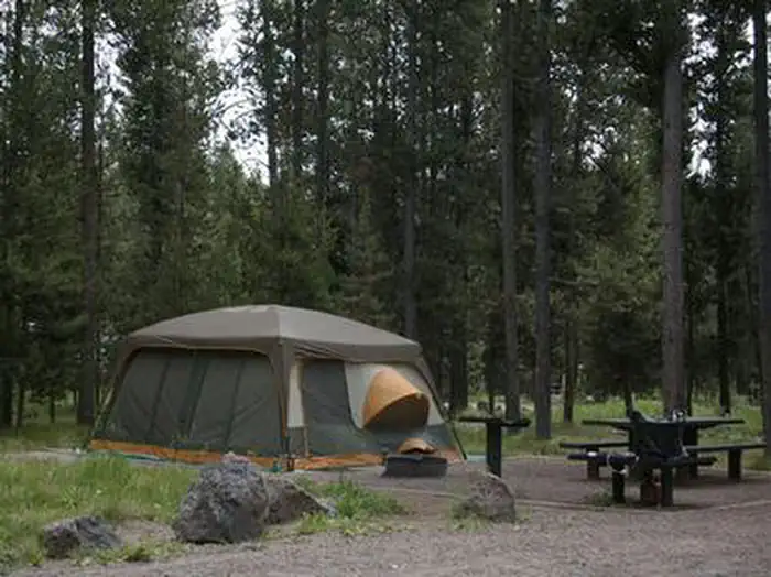
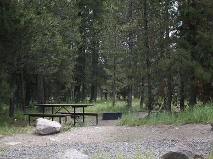
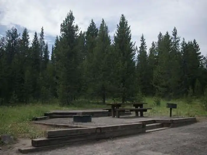
The campground contains single and double campsites, some of which have 50-amp electric hookups. Sites are equipped with picnic and utility tables, a campfire ring and tent pad.Vault toilets, drinking water and trash collection are provided. All interior roads and parking spurs are gravel.
Macks Inn is just across the highway from the campground and offers amenities such as boat rentals, shuttle service, showers, laundry facilities, gas and groceries.
Natural Features
Island Park is composed of two areas of extinct volcanic activity. The Henry's Fork Caldera sits inside the larger Island Park Caldera. The area is known for its dense forests of lodgepole pine, broad grassy meadows bursting with summer wildflowers and a wide variety of wildlife, including black and grizzly bears, moose, elk, deer, bald eagles, Sandhill cranes and much, much more.A mixed growth of lodgepole pine forest provides partial shade. A portion of one loop is fairly close to the river and some sites have river views.
Nearby Attractions
Mesa Falls Scenic Byway is 11 miles south of the campground. This 28-mile road leads to scenic overlooks and trails at 110 foot Upper Mesa Falls and 85 foot Lower Mesa Falls.Harriman State Park is 13 miles south. The Henry's Fork meanders through the Harriman, offering excellent fishing. Over 20 miles of trails are available, and wildlife is abundant in this scenic park.
Henry's Lake State Park is 10 miles north, offering fishing, a fish cleaning station and boat ramp.
Yellowstone National Park's west entrance is just 22 miles north in the town of West Yellowstone, Montana. Visitors enjoy day-tripping to the park for unparalleled wildlife viewing and the beautiful and unique scenery.
The facts
- 16 bookable sites
- 41 sites in total, including non-bookable
- Vehicles up to 65 ft
- Up to 16 people per site
- Loops: FLAT, MANAGEMENT SITES
Site types
- 25 Management
- 10 Standard Nonelectric
- 6 Standard Electric
Amenities
- Electric hookups
- Campfires allowed
- Fire pits
- Picnic tables
- Shade
Not recorded upstream: water hookups, sewer hookups, grills, pets allowed.
41 campsites at Flat Rock (Idaho)
| Site | Loop | Type | Entry | Surface | Max rig | People | |
|---|---|---|---|---|---|---|---|
| B002 | FLAT | Standard Electric | Back In | Gravel | 45 ft | 8 | |
| B003 | FLAT | Standard Nonelectric | Back In | Gravel | 45 ft | 8 | |
| B004 | FLAT | Standard Nonelectric | Back In | Gravel | 45 ft | 8 | |
| B005 | FLAT | Standard Electric | Back In | Gravel | 45 ft | 8 | |
| B006 | FLAT | Standard Electric | Back In | Gravel | 45 ft | 8 | |
| B007 | FLAT | Standard Electric | Back In | Gravel | 50 ft | 8 | |
| B008 | FLAT | Standard Electric | Back In | Gravel | 50 ft | 8 | |
| B009 | FLAT | Standard Electric | Back In | Gravel | 50 ft | 16 | |
| B010 | FLAT | Standard Nonelectric | Back In | Gravel | 45 ft | 8 | |
| B011 | FLAT | Standard Nonelectric | Back In | Gravel | 50 ft | 8 | |
| B012 | FLAT | Standard Nonelectric | Back In | Gravel | 45 ft | 8 | |
| B013 | FLAT | Standard Nonelectric | Back In | Gravel | 45 ft | 8 | |
| B014 | FLAT | Standard Nonelectric | Back In | Gravel | 60 ft | 8 | |
| B015 | FLAT | Standard Nonelectric | Back In | Gravel | 55 ft | 8 | |
| B016 | FLAT | Standard Nonelectric | Back In | Gravel | 65 ft | 8 | |
| B017 | FLAT | Standard Nonelectric | Back In | Gravel | 60 ft | 8 | |
| B001 | MANAGEMENT SITES | Management | Back In | Gravel | 45 ft | 8 | |
| XXX1 | MANAGEMENT SITES | Management | — | — | — | — | |
| XXX10 | MANAGEMENT SITES | Management | — | — | — | — | |
| XXX11 | MANAGEMENT SITES | Management | — | — | — | — | |
| XXX12 | MANAGEMENT SITES | Management | — | — | — | — | |
| XXX13 | MANAGEMENT SITES | Management | — | — | — | — | |
| XXX14 | MANAGEMENT SITES | Management | — | — | — | — | |
| XXX15 | MANAGEMENT SITES | Management | — | — | — | — | |
| XXX16 | MANAGEMENT SITES | Management | — | — | — | — | |
| XXX17 | MANAGEMENT SITES | Management | — | — | — | — | |
| XXX18 | MANAGEMENT SITES | Management | — | — | — | — | |
| XXX19 | MANAGEMENT SITES | Management | — | — | — | — | |
| XXX2 | MANAGEMENT SITES | Management | — | — | — | — | |
| XXX20 | MANAGEMENT SITES | Management | — | — | — | — | |
| XXX21 | MANAGEMENT SITES | Management | — | — | — | — | |
| XXX22 | MANAGEMENT SITES | Management | — | — | — | — | |
| XXX23 | MANAGEMENT SITES | Management | — | — | — | — | |
| XXX24 | MANAGEMENT SITES | Management | — | — | — | — | |
| XXX3 | MANAGEMENT SITES | Management | — | — | — | — | |
| XXX4 | MANAGEMENT SITES | Management | — | — | — | — | |
| XXX5 | MANAGEMENT SITES | Management | — | — | — | — | |
| XXX6 | MANAGEMENT SITES | Management | — | — | — | — | |
| XXX7 | MANAGEMENT SITES | Management | — | — | — | — | |
| XXX8 | MANAGEMENT SITES | Management | — | — | — | — | |
| XXX9 | MANAGEMENT SITES | Management | — | — | — | — |
Getting there
From West Yellowstone, Montana, take U.S. Highway 20 south for 22 miles, or from Ashton, Idaho, take U.S. Highway 20 north for 30 miles. The campground entrance is 1/4 mile south of Macks Inn on the west side of the highway.
44.49694, -111.34000 · 44°29'49.0"N 111°20'24.0"W
Typical weather
| Jan | Feb | Mar | Apr | May | Jun | Jul | Aug | Sep | Oct | Nov | Dec | |
|---|---|---|---|---|---|---|---|---|---|---|---|---|
| High °F | — | — | — | — | — | — | — | — | — | — | — | — |
| Low °F | — | — | — | — | — | — | — | — | — | — | — | — |
| Precip in | 5.2 | 4.8 | 5.1 | 4.4 | 4.3 | 3.7 | 1.5 | 1.6 | 1.8 | 3.1 | 4.4 | 6.2 |
1991–2020 averages from the nearest NOAA station, 4.1 mi away — not measured at the facility itself, and elevation can make a real difference over that distance.
Map
More photos
Member photos
Common questions about Flat Rock (Idaho)
- Can you reserve a site at Flat Rock (Idaho)?
- Yes, Flat Rock (Idaho) is reservable through Recreation.gov.
- How many campsites does Flat Rock (Idaho) have?
- 41 sites in total, of which 16 can be booked.
- What is the maximum RV length at Flat Rock (Idaho)?
- 65 ft. That is the longest vehicle the sites here are recorded as taking; individual sites may be shorter.
- Does Flat Rock (Idaho) have hookups?
- Electric.
- Are campfires allowed at Flat Rock (Idaho)?
- Campfires are allowed at Flat Rock (Idaho). Check for a current fire restriction before you go.
Camping near Flat Rock (Idaho)
- Upper Coffee Pot 1.3 mi · Campground · we watch it
- Big Springs Warming Hut 2.1 mi · Campground · we watch it
- McCrea Bridge 3.8 mi · Campground · we watch it
- Big Springs GRP. Area - Island Park 4.2 mi · Campground · we watch it
- Buffalo (Idaho) 5.1 mi · Campground · we watch it
- Buttermilk 6.2 mi · Campground · we watch it
- Bishop Mountain Cabin 15.4 mi · Campground · we watch it
- Flatrock Campground less than 0.1 mi · Campground
- Upper Coffeepot Campground 1.3 mi · Campground
- Box Canyon Campground 7.9 mi · Campground
- Henrys Lake Boat Access 9 mi · Facility
- West End Campground 12.7 mi · Campground
Contact
- Phone 208-558-7658 OR 208-270-0094
- Book Recreation.gov
Recreation.gov last updated this record on 2026-02-25.
Facility information and photographs from Recreation.gov (RIDB). SpotOpened is not affiliated with Recreation.gov or any federal agency.
Comments