Dearhamer Campground
Campground · Colorado · 12 bookable sites ·
Managed by the USDA Forest Service
White River National Forest (NF) · Open Access
- 12
- Bookable sites
- 69 ft
- Max rig length
- up to 10
- People per site
- 7,778 ft
- Elevation
Overview
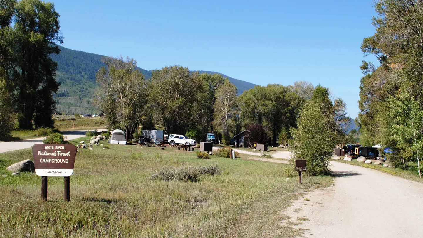
Located approximately 22 miles east of Basalt, Colorado, in the White River National Forest, Dearhamer Campground sits adjacent to the Fryingpan River above Ruedi Reservoir at an elevation of 7,800 feet.Recreation
Renowned for its fly fishing, Fryingpan River flows below Ruedi Dam. Here, large rainbow, brown, cutthroat and brook trout are plentiful in an area nicknamed the "toilet bowl." The fish feed on Mysis shrimp, a small freshwater shrimp stocked in the lake.The stretch of river from the dam down to the confluence of Fryingpan and the Roaring Fork River has been designated as Gold Medal Waters by the Colorado Wildlife Commission. Special regulations in this area include fishing only with artificial flies and lures, and releasing all trout except brown trout, with a limit of 2 fish over 14 inches.
For hikers and bikers, the Ruedi Trail, located north of the reservoir, climbs to the top of Red Table Mountain. The trailhead is located 200 feet north of the Jeep trail near the boat ramp and parking lot. This 8-mile trail gains over 3,000 feet in elevation, leading hikers to a spectacular panoramic view of the area.
Boating, swimming, and water skiing are all possible in the area.
Facilities
Dearhamer Campground has 13 standard sites suitable for tents, trailers, and RVs. There is a maximum length of 35 feet for RVs.The sites are equipped with picnic tables and campfire rings. Guests also have access to vault toilets and a drinking water hydrant, but electrical hook-ups are not available.
Natural Features
In the heart of the Rocky Mountains, the 2.3 million acre White River National Forest is a place of serenity and adventure, boasting 8 wilderness areas, 4 defined seasons, and 10 peaks surpassing 14,000 feet in elevation.Wildlife in the area abounds. Bighorn sheep navigate rocky ridges and bull elk bugle at dusk. Scenic rivers sustain populations of cutthroat, rainbow, and brown trout. Alpine regions provide habitat for pika and ptarmigan. These species, along with many others, depend on surrounding undeveloped wilderness, clean streams, and diverse forests to live.
Nearby Attractions
The nearby town of Aspen is a popular destination for visitors to the area. From downhill skiing and world-class fly fishing, to dining and resorts, there are a multitude of outdoor and indoor opportunities in this resort mountain town.Charges & Cancellations
Once your reservation start date has begun, neither the Recreation.gov Contact Center nor the campground manager will be able to modify your reservation.
The facts
- 12 bookable sites
- 13 sites in total, including non-bookable
- Vehicles up to 69 ft
- Up to 10 people per site
- Loops: DEARHAMER CAMPGROUND
Site types
- 12 Standard Nonelectric
- 1 Management
Amenities
- Campfires allowed
- Fire pits
- Picnic tables
- Shade
- Pets allowed
Not recorded upstream: electric hookups, water hookups, sewer hookups, grills.
13 campsites at Dearhamer Campground
Check-in 2:00 PM · Check-out 11:00 AM
| Site | Loop | Type | Entry | Surface | Water | Max rig | People | |
|---|---|---|---|---|---|---|---|---|
| 001 | DEARHAMER CAMPGROUND | Standard Nonelectric | Back In | Gravel | Riverfront | 52 ft | 10 | 🐾 |
| 002 | DEARHAMER CAMPGROUND | Standard Nonelectric | Back In | Gravel | Riverfront | 69 ft | 10 | 🐾 |
| 003 | DEARHAMER CAMPGROUND | Standard Nonelectric | Back In | Gravel | Riverfront | 49 ft | 10 | 🐾 |
| 004 | DEARHAMER CAMPGROUND | Standard Nonelectric | Back In | Gravel | — | 36 ft | 10 | 🐾 |
| 005 | DEARHAMER CAMPGROUND | Standard Nonelectric | Back In | Gravel | Riverfront | 40 ft | 10 | 🐾 |
| 006 | DEARHAMER CAMPGROUND | Management | Back In | Gravel | — | 52 ft | 10 | 🐾 |
| 007 | DEARHAMER CAMPGROUND | Standard Nonelectric | Back In | Gravel | — | 45 ft | 10 | 🐾 |
| 008 | DEARHAMER CAMPGROUND | Standard Nonelectric | Back In | Gravel | — | 38 ft | 10 | 🐾 |
| 009 | DEARHAMER CAMPGROUND | Standard Nonelectric | Back In | Gravel | — | 30 ft | 10 | 🐾 |
| 010 | DEARHAMER CAMPGROUND | Standard Nonelectric | Back In | Gravel | — | 42 ft | 10 | 🐾 |
| 011 | DEARHAMER CAMPGROUND | Standard Nonelectric | Back In | Gravel | — | 47 ft | 10 | 🐾 |
| 012 | DEARHAMER CAMPGROUND | Standard Nonelectric | Back In | Gravel | — | 42 ft | 10 | 🐾 |
| 013 | DEARHAMER CAMPGROUND | Standard Nonelectric | Back In | Gravel | — | 60 ft | 10 | 🐾 |
Getting there
39.36088, -106.73869 · 39°21'39.2"N 106°44'19.3"W
Typical weather
Typically 81°F in Jul, down to 34°F in Dec.
| Jan | Feb | Mar | Apr | May | Jun | Jul | Aug | Sep | Oct | Nov | Dec | |
|---|---|---|---|---|---|---|---|---|---|---|---|---|
| High °F | 34 | 36 | 43 | 51 | 63 | 75 | 81 | 80 | 71 | 61 | 45 | 34 |
| Low °F | 4 | 6 | 13 | 21 | 28 | 34 | 40 | 39 | 32 | 23 | 13 | 5 |
| Precip in | — | — | — | — | — | — | — | — | — | — | — | — |
1991–2020 averages from the nearest NOAA station, 0.2 mi away — not measured at the facility itself, and elevation can make a real difference over that distance.
Map
More photos
Member photos
Common questions about Dearhamer Campground
- Can you reserve a site at Dearhamer Campground?
- Yes, Dearhamer Campground is reservable through Recreation.gov.
- How many campsites does Dearhamer Campground have?
- 13 sites in total, of which 12 can be booked.
- What is the maximum RV length at Dearhamer Campground?
- 69 ft. That is the longest vehicle the sites here are recorded as taking; individual sites may be shorter.
- Are pets allowed at Dearhamer Campground?
- Yes, pets are allowed at Dearhamer Campground.
- Are campfires allowed at Dearhamer Campground?
- Campfires are allowed at Dearhamer Campground. Check for a current fire restriction before you go.
Camping near Dearhamer Campground
- Little Mattie Campground 3.8 mi · Campground · we watch it
- Ruedi Boat Storage Parking Lot Lottery 4.1 mi · Tickets · we watch it
- Ruedi Marina Campground 4.1 mi · Campground · we watch it
- Mollie B_white River 4.2 mi · Campground · we watch it
- Little Maud Campground 4.2 mi · Campground · we watch it
- Chapman Campground and Group 6.7 mi · Campground · we watch it
- Ruedi Marina Boat Ramp 4 mi · Facility
- Mollie B Campground 4.2 mi · Campground
- Last Chance #1945 5.7 mi · Facility
- Mount Thomas #1870 6.1 mi · Facility
- Aspen-Norrie #1927 6.1 mi · Facility
- Elk Wallow Campground 6.8 mi · Campground
Contact
- Phone 801-226-3564
- Email Help.WhiteRiver.Sopris@AmericanLL.com
- Book Recreation.gov
Recreation.gov last updated this record on 2026-03-11.
Facility information and photographs from Recreation.gov (RIDB). SpotOpened is not affiliated with Recreation.gov or any federal agency.
Comments