Whiskeytown National Recreation Area Ranger-Guided Kayak and Paddle Board Tours
Tickets · California ·
Managed by the National Park Service
Lassen National Forest (NF) · Open Access
- 5,216 ft
- Elevation
Overview:
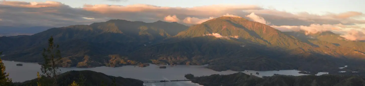
Whiskeytown National Recreation Area, located in northern California, is a unit of the National Park Service. The 42,000-acre park is situated eight miles west of Redding at the northern edge of the Sacramento river valley, in the foothills of the Klamath Mountains. The park was established in 1965 as part of the Central Valley project. Whiskeytown Lake provides a dependable water supply, flood control, hydroelectric power, and numerous recreational opportunities. Each year, approximately 800 thousand visitors come to enjoy the unique experiences that only can be had at Whiskeytown.We invite you to explore the park's natural beauty, majestic views, and abundant wildlife via kayak or paddle board while participating in a ranger-guided tour.
Getting there
Link to park map:
Directions to the Ranger-Guided Kayak and Paddle Board Programs:
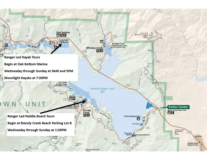
Kayakers: meet at Oak Bottom at the kayak shed near the amphitheater. The Oak Bottom area is on the north shore of Whiskeytown Lake, 5.1 miles west of the visitor center if approaching from the east (Redding), or 3.3 miles east of the junction of highway 299 and Trinity Mountain Rd., if approaching from the west (Eureka/Weaverville).
Paddle Boarders: Meet at Brandy Creek Beach Lot "B": Brandy Creek is on the south shore of Whiskeytown Lake. Traveling from Redding on Highway 299, turn left at the visitor center onto John F. Kennedy Memorial Drive. Brandy Creek Beach is approximately 4.2 miles from the visitor center. You will drive across the dam and continue on until you see the signs for "Brandy Creek Beach". Turn right at Brandy Creek Beach and follow the access road to Brandy Creek parking, Lot "B". Look for the brown metal shed at the north end of the parking lot.
Directions to the Whiskeytown National Recreation Area Visitor Center:
From the East via Redding, CA: The park's only visitor center is located on the eastern shore of Whiskeytown Lake, eight miles (13 km) west of Redding, CA, at the intersection of state highway 299 and Kennedy Memorial Drive.
From the West via Eureka/Weaverville, CA: State highway 299 enters the park at its NW boundary near the intersection of state highway 299 and Trinity Mountain Rd. From this intersection, continue 8.4 miles (13.5 km) to the visitor center, located at the intersection of highway 299 and Kennedy Memorial Dr.
NOTE: Ranger Guided Programs DO NOT begin at the visitor center.
Directions to the Ranger-Guided Kayak and Paddle Board Programs:
Directions to the Whiskeytown National Recreation Area Visitor Center:
NOTE: Ranger Guided Programs DO NOT begin at the visitor center.
40.61500, -121.52019 · 40°36'54.0"N 121°31'12.7"W
Typical weather
Typically 79°F in Jul, down to 40°F in Dec.
| Jan | Feb | Mar | Apr | May | Jun | Jul | Aug | Sep | Oct | Nov | Dec | |
|---|---|---|---|---|---|---|---|---|---|---|---|---|
| High °F | 41 | 42 | 46 | 50 | 61 | 70 | 79 | 78 | 72 | 59 | 47 | 40 |
| Low °F | 22 | 22 | 24 | 28 | 35 | 41 | 46 | 45 | 41 | 33 | 26 | 22 |
| Precip in | 6.5 | 5.5 | 6.4 | 4.3 | 2.9 | 1.3 | 0.3 | 0.3 | 0.7 | 2.7 | 4.7 | 6.5 |
1991–2020 averages from the nearest NOAA station, 5.9 mi away — not measured at the facility itself, and elevation can make a real difference over that distance.
Map
More photos
Member photos
Common questions about Whiskeytown National Recreation Area Ranger-Guided Kayak and Paddle Board Tours
- Can you reserve a site at Whiskeytown National Recreation Area Ranger-Guided Kayak and Paddle Board Tours?
- Yes, Whiskeytown National Recreation Area Ranger-Guided Kayak and Paddle Board Tours is reservable through Recreation.gov.
Camping near Whiskeytown National Recreation Area Ranger-Guided Kayak and Paddle Board Tours
- Lost Creek Group 3.6 mi · Campground · we watch it
- Hat Creek 5.3 mi · Campground · we watch it
- Manzanita Lake Camping Cabins (CA) 6.3 mi · Campground · we watch it
- Manzanita Lake Group Campground 6.4 mi · Campground · we watch it
- Manzanita Lake 6.4 mi · Campground · we watch it
- Big Pine Campground 3.1 mi · Campground
- Loomis Museum 5.9 mi · Facility
- Old Station Visitor Information Center 6.7 mi · Facility
- Cave Campground 7 mi · Campground
- Rocky Campground 9.1 mi · Campground
- Bridge Campground 9.1 mi · Campground
- Cypress Trailhead 9.7 mi · Facility
Contact
- Phone 530-246-1225
- Email whis_information@nps.gov
- Book Recreation.gov
Recreation.gov last updated this record on 2026-02-25.
Facility information and photographs from Recreation.gov (RIDB). SpotOpened is not affiliated with Recreation.gov or any federal agency.
Comments