Shirttail Creek
Campground · California · 29 bookable sites ·
Managed by the USDA Forest Service
Tahoe National Forest (NF) · Open Access
- 29
- Bookable sites
- 100 ft
- Max rig length
- up to 18
- People per site
- 3
- Accessible sites
- 3,676 ft
- Elevation
Overview
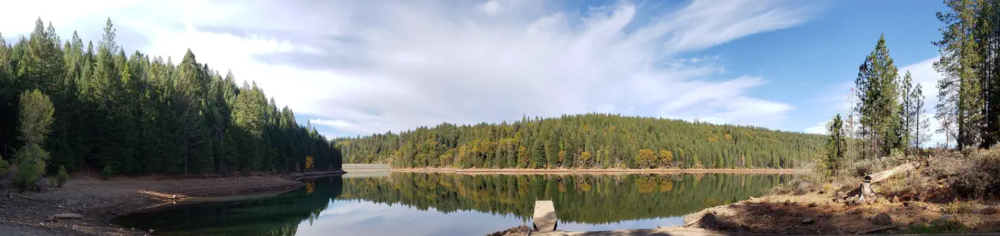
Shirttail Campground is located on the north shore of Sugar Pine Reservoir, in the Tahoe National Forest, 15 miles from Foresthill. Visitors enjoy the area for its fishing, boating, OHV, and hiking opportunities. This facility is operated and maintained by the Tahoe National Forest.Recreation
Fishing, swimming and both motorized and non-motorized boating are popular activities on the reservoir. A paved, non-motorized accessible trail connects recreation sites on the north shore with recreation sites on the south shore and has interpretive signs and shaded benches for rest breaks. The North Fork of the American River is nearby, with additional fishing, white water boating, and swimming. Many miles of hiking, biking and off-road vehicle trails are in the surrounding area.Facilities
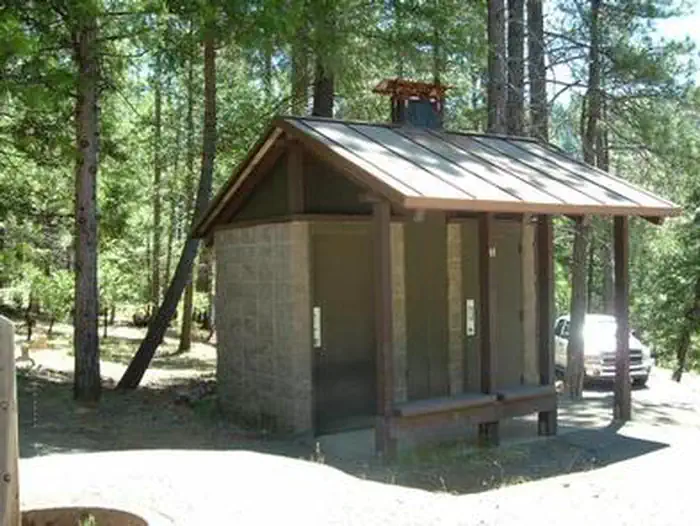
The campground offers single and double family campsites and one triple site; a few of the campsites are accessible. Picnic tables, campfire rings and grills are provided, as well as vault toilets and drinking water. Firewood is available for purchase from the host.Natural Features
Sugar Pine Reservoir covers 160 acres at an elevation of 3600 feet. The campground lies above the north shoreline, in a forest of manzanita and ponderosa pine. Summertime temperatures are warm during the day and cool at night.Nearby Attractions
Shirttail Creek Campground is a recreation site within the Sugar Pine Recreation Area which includes an additional family campground, a group campground, a boat ramp, and a day use picnic site, as well as a trail that circles the entire lake. The North Fork American Wild And Scenic River can be accessed near by. Other recreation opportunities include many hiking, equestrian, mountain biking, and OHV trails.The facts
- Season: April 30 – October 31 — USDA Forest Service, Aug 24, 2026
- 29 bookable sites
- 41 sites in total, including non-bookable
- 3 accessible sites
- Vehicles up to 100 ft
- Up to 18 people per site
- Loops: AREA SHIRTTAIL CREEK
Site types
- 27 Standard Nonelectric
- 12 Management
- 2 Tent Only Nonelectric
Amenities
- Shade
- Pets allowed
Not recorded upstream: electric hookups, water hookups, sewer hookups, campfires allowed, fire pits, picnic tables, grills.
41 campsites at Shirttail Creek
| Site | Loop | Type | Entry | Surface | Max rig | People | |
|---|---|---|---|---|---|---|---|
| 001 | AREA SHIRTTAIL CREEK | Standard Nonelectric | Back In | Paved | 45 ft | 6 | 🐾 |
| 002 | AREA SHIRTTAIL CREEK | Standard Nonelectric | Back In | Paved | — | 6 | 🐾 |
| 002 | AREA SHIRTTAIL CREEK | Management | Back In | Paved | 45 ft | 6 | 🐾 |
| 003 | AREA SHIRTTAIL CREEK | Standard Nonelectric | Back In | Paved | 45 ft | 12 | 🐾 |
| 004 | AREA SHIRTTAIL CREEK | Standard Nonelectric | Back In | Paved | 40 ft | 6 | 🐾 |
| 005 | AREA SHIRTTAIL CREEK | Standard Nonelectric | Back In | Paved | — | 6 | 🐾 |
| 005 | AREA SHIRTTAIL CREEK | Management | Back In | Paved | 45 ft | 6 | 🐾 |
| 006 | AREA SHIRTTAIL CREEK | Standard Nonelectric | Back In | Paved | 35 ft | 6 | 🐾 |
| 007 | AREA SHIRTTAIL CREEK | Standard Nonelectric | Back In | Paved | 35 ft | 6 | ♿ 🐾 |
| 008 | AREA SHIRTTAIL CREEK | Tent Only Nonelectric | Back In | Paved | — | 6 | 🐾 |
| 009 | AREA SHIRTTAIL CREEK | Standard Nonelectric | — | Paved | 35 ft | 6 | 🐾 |
| 010 | AREA SHIRTTAIL CREEK | Standard Nonelectric | Back In | Paved | 40 ft | 6 | 🐾 |
| 011 | AREA SHIRTTAIL CREEK | Tent Only Nonelectric | Back In | Paved | — | 6 | 🐾 |
| 012 | AREA SHIRTTAIL CREEK | Standard Nonelectric | Back In | Paved | 40 ft | 6 | 🐾 |
| 013 | AREA SHIRTTAIL CREEK | Standard Nonelectric | Back In | Paved | 30 ft | 6 | 🐾 |
| 014 | AREA SHIRTTAIL CREEK | Standard Nonelectric | Back In | Paved | 35 ft | 12 | 🐾 |
| 014 | AREA SHIRTTAIL CREEK | Management | Back In | Paved | 45 ft | 6 | 🐾 |
| 015 | AREA SHIRTTAIL CREEK | Management | Back In | Paved | 40 ft | 6 | 🐾 |
| 016 | AREA SHIRTTAIL CREEK | Standard Nonelectric | Back In | Paved | — | 0 | 🐾 |
| 016 | AREA SHIRTTAIL CREEK | Management | Back In | Paved | 45 ft | 6 | 🐾 |
| 017 | AREA SHIRTTAIL CREEK | Standard Nonelectric | Back In | Paved | — | 6 | 🐾 |
| 017 | AREA SHIRTTAIL CREEK | Management | Back In | Gravel | 45 ft | 6 | 🐾 |
| 018 | AREA SHIRTTAIL CREEK | Standard Nonelectric | Back In | Paved | 40 ft | 6 | 🐾 |
| 019 | AREA SHIRTTAIL CREEK | Standard Nonelectric | Back In | Paved | 40 ft | 6 | 🐾 |
| 020 | AREA SHIRTTAIL CREEK | Standard Nonelectric | Back In | Paved | 35 ft | 12 | 🐾 |
| 021 | AREA SHIRTTAIL CREEK | Standard Nonelectric | Back In | Paved | — | 6 | 🐾 |
| 021 | AREA SHIRTTAIL CREEK | Management | Back In | Paved | 45 ft | 6 | 🐾 |
| 022 | AREA SHIRTTAIL CREEK | Standard Nonelectric | Pull Through | Paved | 50 ft | 12 | 🐾 |
| 023 | AREA SHIRTTAIL CREEK | Standard Nonelectric | Back In | Paved | 31 ft | 6 | 🐾 |
| 024 | AREA SHIRTTAIL CREEK | Standard Nonelectric | Back In | Paved | — | 6 | 🐾 |
| 024 | AREA SHIRTTAIL CREEK | Management | Back In | Paved | 45 ft | 6 | 🐾 |
| 025 | AREA SHIRTTAIL CREEK | Standard Nonelectric | Pull Through | Paved | 100 ft | 18 | 🐾 |
| 026 | AREA SHIRTTAIL CREEK | Standard Nonelectric | Back In | Paved | 30 ft | 6 | ♿ 🐾 |
| 027 | AREA SHIRTTAIL CREEK | Standard Nonelectric | Back In | Paved | — | 12 | 🐾 |
| 027 | AREA SHIRTTAIL CREEK | Management | Back In | Paved | 45 ft | 6 | 🐾 |
| 028 | AREA SHIRTTAIL CREEK | Standard Nonelectric | Back In | Paved | — | 0 | 🐾 |
| 028 | AREA SHIRTTAIL CREEK | Management | Back In | Paved | 45 ft | 6 | 🐾 |
| 029 | AREA SHIRTTAIL CREEK | Standard Nonelectric | Back In | Paved | 50 ft | 6 | ♿ 🐾 |
| 030 | AREA SHIRTTAIL CREEK | Standard Nonelectric | Back In | Paved | 40 ft | 12 | 🐾 |
| XXX | AREA SHIRTTAIL CREEK | Management | Back In | Paved | 45 ft | 6 | 🐾 |
| XXX10 | AREA SHIRTTAIL CREEK | Management | — | — | — | — |
Getting there
39.14192, -120.78649 · 39°8'30.9"N 120°47'11.3"W
Typical weather
| Jan | Feb | Mar | Apr | May | Jun | Jul | Aug | Sep | Oct | Nov | Dec | |
|---|---|---|---|---|---|---|---|---|---|---|---|---|
| High °F | — | — | — | — | — | — | — | — | — | — | — | — |
| Low °F | — | — | — | — | — | — | — | — | — | — | — | — |
| Precip in | 9.2 | 8.7 | 8.2 | 4.7 | 3.0 | 0.9 | 0.0 | 0.1 | 0.6 | 2.9 | 5.8 | 10.4 |
1991–2020 averages from the nearest NOAA station, 4.1 mi away — not measured at the facility itself, and elevation can make a real difference over that distance.
Map
Fees and stay limits
Single campsites (8 people) $24.00, double campsites (16 people) $48.00, triple campsite (24 people) $72.00.
From Recreation.gov, which is not always current. The operator's own page is the authority on what you will be charged.
More photos
Member photos
Common questions about Shirttail Creek
- Can you reserve a site at Shirttail Creek?
- Yes, Shirttail Creek is reservable through Recreation.gov.
- How many campsites does Shirttail Creek have?
- 41 sites in total, of which 29 can be booked.
- What is the maximum RV length at Shirttail Creek?
- 100 ft. That is the longest vehicle the sites here are recorded as taking; individual sites may be shorter.
- Are pets allowed at Shirttail Creek?
- Yes, pets are allowed at Shirttail Creek.
Also listed by
Shirttail Creek also appears in other federal recreation data. Facts below are matched by name and location, not confirmed by Shirttail Creek's operator.
USDA Forest Service — data as of Aug 24, 2026
- $24/single site (6 people), $48/double site (12 people), $72/triple site (18 people) Trailer dump station open on Sundays from 11am to 1pm, $6. Dump station may be available on demand, please contact camp hosts.
Restrictions:
- OHV use is not permitted in the Sugar Pine Complex, only the staging area.
Accessibility:
- Restrooms, several campsites and paved trail
Camping near Shirttail Creek
- Giant Gap 0.4 mi · Campground · we watch it
- Forbes Creek 0.8 mi · Campground · we watch it
- Tunnel Mills II 10.5 mi · Campground · we watch it
- Manzanita Day Use, Swim Area Picnic Site 0.1 mi · Facility
- Sugar Pine Boat Ramp 0.9 mi · Facility
- Big Reservoir Campground 1.7 mi · Campground
- Sugar Pine Staging Area 1.9 mi · Facility
- China Wall Staging Area 5.9 mi · Facility
- Foresthill Divide Road 5.9 mi · Facility
- Foresthill Divide Driving Tour Interpretive Site 5.9 mi · Facility
- Oxbow Raft Put-in Site 9.6 mi · Facility
- Ralston Picnic Site 9.9 mi · Facility
Contact
- Phone 530-367-2224
- Book Recreation.gov
Recreation.gov last updated this record on 2026-06-19.
Facility information and photographs from Recreation.gov (RIDB). SpotOpened is not affiliated with Recreation.gov or any federal agency.
Comments