Christie Campground
Campground · California · 66 bookable sites ·
Managed by the USDA Forest Service
Lassen National Forest (NF) · Open Access
- 66
- Bookable sites
- 65 ft
- Max rig length
- up to 16
- People per site
- 5,143 ft
- Elevation
Overview
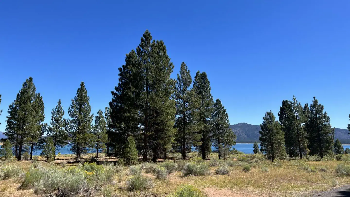
Christie Campground is located in the Eagle Lake Recreation Area of the Lassen National Forest. This recreation area has five campgrounds, three designated day use areas and a marina on the south shore of Eagle Lake. All these recreation facilities are connected by a 5.2 mile paved hiking/bike trail. The Osprey Overlook, another day use area in the recreation area, can be hiked or driven to for a scenic view of the southern end of Eagle Lake and the surrounding forest basin.
The Lassen National Forest offers a variety of lakes, streams and wilderness areas for recreational opportunities. The forest offers miles of trails that are used for hiking, mountain biking, off-highway vehicle riding and in the winter months, snowmobiling.
Recreation
Fishing for the Eagle Lake Rainbow Trout, a California Heritage Trout, is the primary recreational activity on Eagle Lake, but the 3rd largest natural lake in California (22,000 acres), provides for plenty of room for swimming, kayaking, skiing and all other boating activities by motor or sail. There are no 2-cycle restrictions for outboard boat motors or PWCs.
Facilities
Of the five campgrounds in the recreation area, Christie Campground is located the greatest distance from the marina and boat ramp, about five miles or a 10-minute drive. Due to its location, this campground is the least used and occupied in the recreation area. This distinction has developed a very loyal customer base of RV, trailer and tent campers who want a quiet, spacious, camping experience in this beautiful landscape.
Christie Campground’s location offers OHV riders almost direct access to the Forest Service riding trails and roads and is preferred by kayak and personal pontoon fishing enthusiasts.
Each site is equipped with a paved parking spur, table and campfire ring/grill. Almost half of the sites feature a pull-through parking spur and nine of these sites are large enough that they have been designated as group sites.
An RV Dump Station Facility is conveniently located about two miles away with a $5 dump fee.
Forty-seven sites, #1-#25, #27-#30, and #32-#49 are designated reservation sites, the other 22 sites are walk-in sites, available on a first-come, first-served basis.
The paved bike path begins in this campground. The Eagle Lake Marina store with gas, propane, fishing and camping supplies, shower and laundry facilities.
Natural Features
Eagle Lake is located where the Sierras meet the Cascades at the southwestern end of the lake, and the Modoc Plateau of the Great Basin at the northeastern end. This unique location offers diverse landscapes, geology, wildlife and vegetation.
Christie Campground is located in a mature conifer forest of pines and firs, on the southwestern shoreline of Eagle Lake, at an elevation of 5,100 feet.
Contact Info
For facility specific information, please call (530) 825-3454.Nearby Attractions
The Lassen National Forest has many other recreational opportunities and the Lassen Volcanic National Park is an easy day’s drive to and from Eagle Lake Recreational Area.
The facts
- Season: May – September — USDA Forest Service, Aug 24, 2026
- 66 bookable sites
- 69 sites in total, including non-bookable
- Vehicles up to 65 ft
- Up to 16 people per site
- Loops: MAHOGONY, MANAGEMENT, MANZANITA, TROY
Site types
- 51 Standard Nonelectric
- 10 Group Standard Nonelectric
- 5 RV Nonelectric
- 3 Management
Amenities
- Campfires allowed
- Fire pits
- Picnic tables
- Grills
- Shade
- Pets allowed
Not recorded upstream: electric hookups, water hookups, sewer hookups.
69 campsites at Christie Campground
Check-in 1:00 PM · Check-out 12:00 PM
| Site | Loop | Type | Entry | Surface | Grade | Max rig | People | |
|---|---|---|---|---|---|---|---|---|
| 50 | MAHOGONY | Standard Nonelectric | Pull Through | Paved | — | 65 ft | 8 | 🐾 |
| 51 | MAHOGONY | Standard Nonelectric | Back In | Paved | — | 50 ft | 8 | 🐾 |
| 52 | MAHOGONY | Standard Nonelectric | Back In | Paved | — | 50 ft | 8 | 🐾 |
| 53 | MAHOGONY | Standard Nonelectric | Pull Through | Paved | — | 60 ft | 8 | 🐾 |
| 54 | MAHOGONY | Standard Nonelectric | Back In | Paved | Slight | 45 ft | 8 | 🐾 |
| 55 | MAHOGONY | Standard Nonelectric | Back In | Paved | Slight | 50 ft | 8 | 🐾 |
| 56 | MAHOGONY | Standard Nonelectric | Pull Through | Paved | — | 60 ft | 8 | 🐾 |
| 57 | MAHOGONY | Standard Nonelectric | Back In | Paved | — | 45 ft | 8 | 🐾 |
| 58 | MAHOGONY | Group Standard Nonelectric | Pull Through | Paved | — | 65 ft | 16 | 🐾 |
| 59 | MAHOGONY | Standard Nonelectric | Back In | Paved | — | 45 ft | 8 | 🐾 |
| 60 | MAHOGONY | Standard Nonelectric | Back In | Paved | — | 50 ft | 8 | 🐾 |
| 61 | MAHOGONY | Standard Nonelectric | Back In | Paved | — | 45 ft | 8 | 🐾 |
| 62 | MAHOGONY | Group Standard Nonelectric | Pull Through | Paved | — | 65 ft | 16 | 🐾 |
| 63 | MAHOGONY | Standard Nonelectric | Pull Through | Paved | Slight | 60 ft | 8 | 🐾 |
| 64 | MAHOGONY | Standard Nonelectric | Back In | Paved | Slight | 45 ft | 8 | 🐾 |
| 65 | MAHOGONY | Standard Nonelectric | Pull Through | Paved | Slight | 60 ft | 8 | 🐾 |
| 66 | MAHOGONY | Standard Nonelectric | Back In | Paved | — | 45 ft | 8 | 🐾 |
| 67 | MAHOGONY | Standard Nonelectric | Back In | Paved | — | 45 ft | 8 | 🐾 |
| 68 | MAHOGONY | Standard Nonelectric | Back In | Paved | — | 45 ft | 8 | 🐾 |
| 69 | MAHOGONY | Standard Nonelectric | Pull Through | Paved | — | 65 ft | 8 | 🐾 |
| 26 | MANAGEMENT | Management | Pull Through | Paved | — | 60 ft | 8 | 🐾 |
| 31 | MANAGEMENT | Management | Back In | Paved | — | 40 ft | 8 | 🐾 |
| 27 | MANZANITA | Standard Nonelectric | Back In | Paved | — | 40 ft | 8 | 🐾 |
| 28 | MANZANITA | Standard Nonelectric | Pull Through | Paved | — | 55 ft | 8 | 🐾 |
| 29 | MANZANITA | Standard Nonelectric | Pull Through | Paved | — | 60 ft | 8 | 🐾 |
| 30 | MANZANITA | Standard Nonelectric | Pull Through | Paved | Moderate | 60 ft | 8 | 🐾 |
| 32 | MANZANITA | Standard Nonelectric | Back In | Paved | — | 45 ft | 8 | 🐾 |
| 33 | MANZANITA | Standard Nonelectric | Pull Through | Paved | Moderate | 60 ft | 8 | 🐾 |
| 34 | MANZANITA | Management | Pull Through | Paved | Slight | 50 ft | 8 | 🐾 |
| 35 | MANZANITA | Standard Nonelectric | Back In | Paved | — | 45 ft | 8 | 🐾 |
| 36 | MANZANITA | Group Standard Nonelectric | Pull Through | Paved | — | 60 ft | 16 | 🐾 |
| 37 | MANZANITA | Standard Nonelectric | Back In | Paved | — | 50 ft | 8 | 🐾 |
| 38 | MANZANITA | Standard Nonelectric | Back In | Paved | — | 45 ft | 8 | 🐾 |
| 39 | MANZANITA | Group Standard Nonelectric | Pull Through | Paved | — | 60 ft | 16 | 🐾 |
| 40 | MANZANITA | Group Standard Nonelectric | Pull Through | Paved | — | 60 ft | 16 | 🐾 |
| 41 | MANZANITA | Standard Nonelectric | Back In | Paved | Slight | 45 ft | 8 | 🐾 |
| 42 | MANZANITA | Standard Nonelectric | Pull Through | Paved | Slight | 60 ft | 8 | 🐾 |
| 43 | MANZANITA | Standard Nonelectric | Back In | Paved | — | 45 ft | 8 | 🐾 |
| 44 | MANZANITA | Standard Nonelectric | Pull Through | Paved | Slight | 60 ft | 8 | 🐾 |
| 45 | MANZANITA | Standard Nonelectric | Back In | Paved | — | 40 ft | 8 | 🐾 |
| 46 | MANZANITA | Standard Nonelectric | Back In | Paved | Slight | 45 ft | 8 | 🐾 |
| 47 | MANZANITA | Standard Nonelectric | Pull Through | Paved | — | 60 ft | 8 | 🐾 |
| 48 | MANZANITA | Standard Nonelectric | Back In | Paved | — | 50 ft | 8 | 🐾 |
| 49 | MANZANITA | Standard Nonelectric | Back In | Paved | — | 50 ft | 8 | 🐾 |
| 01 | TROY | Standard Nonelectric | Back In | Paved | — | 40 ft | 8 | 🐾 |
| 02 | TROY | Rv Nonelectric | Pull Through | Paved | — | 45 ft | 8 | 🐾 |
| 03 | TROY | Rv Nonelectric | Pull Through | Paved | — | 45 ft | 8 | 🐾 |
| 04 | TROY | Standard Nonelectric | Back In | Paved | — | 45 ft | 8 | 🐾 |
| 05 | TROY | Standard Nonelectric | Back In | Paved | — | 40 ft | 8 | 🐾 |
| 06 | TROY | Standard Nonelectric | Back In | Paved | — | 40 ft | 8 | 🐾 |
| 07 | TROY | Rv Nonelectric | Pull Through | Paved | — | 45 ft | 8 | 🐾 |
| 08 | TROY | Standard Nonelectric | Back In | Paved | — | 45 ft | 8 | 🐾 |
| 09 | TROY | Group Standard Nonelectric | Pull Through | Paved | — | 45 ft | 16 | 🐾 |
| 10 | TROY | Standard Nonelectric | Back In | Paved | — | 45 ft | 8 | 🐾 |
| 11 | TROY | Group Standard Nonelectric | Pull Through | Paved | — | 45 ft | 16 | 🐾 |
| 12 | TROY | Standard Nonelectric | Back In | Paved | — | 35 ft | 8 | 🐾 |
| 13 | TROY | Group Standard Nonelectric | Pull Through | Paved | — | 45 ft | 16 | 🐾 |
| 14 | TROY | Standard Nonelectric | Back In | Paved | — | 35 ft | 8 | 🐾 |
| 15 | TROY | Standard Nonelectric | Back In | Paved | — | 40 ft | 8 | 🐾 |
| 16 | TROY | Standard Nonelectric | Back In | Paved | — | 40 ft | 8 | 🐾 |
| 17 | TROY | Standard Nonelectric | Back In | Paved | — | 35 ft | 8 | 🐾 |
| 18 | TROY | Group Standard Nonelectric | Pull Through | Paved | — | 45 ft | 16 | 🐾 |
| 19 | TROY | Standard Nonelectric | Back In | Paved | — | 45 ft | 8 | 🐾 |
| 20 | TROY | Rv Nonelectric | Pull Through | Paved | — | 45 ft | 8 | 🐾 |
| 21 | TROY | Standard Nonelectric | Back In | Paved | — | 45 ft | 8 | 🐾 |
| 22 | TROY | Rv Nonelectric | Pull Through | Paved | — | 45 ft | 8 | 🐾 |
| 23 | TROY | Standard Nonelectric | Back In | Paved | — | 45 ft | 8 | 🐾 |
| 24 | TROY | Group Standard Nonelectric | Pull Through | Paved | — | 45 ft | 16 | 🐾 |
| 25 | TROY | Standard Nonelectric | Back In | Paved | — | 45 ft | 8 | 🐾 |
Getting there
From Susanville, California, take Highway 36 west for 2 miles to County Road A-1. Turn north and continue 14 miles to the Eagle Lake Recreation Area. Continue past Gallatin Road, the first highway you will come to in the lake basin, and follow the signs to Christie Campground. Located on County Road A-1, 2 miles north of Merrill Campground.
40.56639, -120.83878 · 40°33'59.0"N 120°50'19.6"W
Typical weather
Typically 88°F in Jul, down to 43°F in Dec.
| Jan | Feb | Mar | Apr | May | Jun | Jul | Aug | Sep | Oct | Nov | Dec | |
|---|---|---|---|---|---|---|---|---|---|---|---|---|
| High °F | 43 | 48 | 54 | 61 | 69 | 79 | 88 | 87 | 80 | 67 | 52 | 43 |
| Low °F | 22 | 26 | 30 | 34 | 40 | 47 | 53 | 52 | 45 | 36 | 28 | 22 |
| Precip in | 2.4 | 2.3 | 1.7 | 0.5 | 0.8 | 0.4 | 0.2 | 0.1 | 0.2 | 1.0 | 1.5 | 1.9 |
1991–2020 averages from the nearest NOAA station, 13.9 mi away — not measured at the facility itself, and elevation can make a real difference over that distance.
Map
More photos
Member photos
Common questions about Christie Campground
- Can you reserve a site at Christie Campground?
- Yes, Christie Campground is reservable through Recreation.gov.
- How many campsites does Christie Campground have?
- 69 sites in total, of which 66 can be booked.
- What is the maximum RV length at Christie Campground?
- 65 ft. That is the longest vehicle the sites here are recorded as taking; individual sites may be shorter.
- Are pets allowed at Christie Campground?
- Yes, pets are allowed at Christie Campground.
- Are campfires allowed at Christie Campground?
- Campfires are allowed at Christie Campground. Check for a current fire restriction before you go.
Also listed by
Christie Campground also appears in other federal recreation data. Facts below are matched by name and location, not confirmed by Christie Campground's operator.
USDA Forest Service — data as of Aug 24, 2026
Restrictions:
- Quiet time 10PM -AM.
Camping near Christie Campground
- Merrill Campground 1.9 mi · Campground · we watch it
- Eagle Campground 3.2 mi · Campground · we watch it
- West Eagle Campground 3.3 mi · Campground · we watch it
- Aspen Grove Campground (CA) 3.5 mi · Campground · we watch it
- Gallatin Marina 3 mi · Facility
- Rocky Point - East 9 mi · Facility
- Rocky Point - West 9 mi · Facility
- Goumaz 10.6 mi · Facility
- Devil's Corral Trailhead 12.2 mi · Facility
- Eagle Lake Ranger District 12.3 mi · Facility
- Crater Lake 12.4 mi · Campground
- Bogard Campground 13.6 mi · Campground
Contact
- Phone 530-825-3212
- Book Recreation.gov
Recreation.gov last updated this record on 2026-02-25.
Facility information and photographs from Recreation.gov (RIDB). SpotOpened is not affiliated with Recreation.gov or any federal agency.
Comments