Cossatot Reefs
Campground · Arkansas · 31 bookable sites ·
Managed by the US Army Corps of Engineers
Gillham Recreation Area (Recreation Area) · Open Access
- 31
- Bookable sites
- 68 ft
- Max rig length
- up to 100
- People per site
- 1
- Accessible site
- 511 ft
- Elevation
Overview
Cossatot Reefs Campground sits along the lush banks of Gillham Lake in southwest Arkansas.Nicknamed the "Bright Spot on the Cossatot," Gillham Lake is a recreational oasis for outdoor enthusiasts.
Recreation
Visitors enjoy the lake for its vast boating opportunities, and a boat ramp is provided for easy water access. The river can be canoed from a point below the dam to U.S. Highway 71 South, a distance of about 16 miles. For shorter canoe trips, there are access roads to the river at Mize Crossing and Ladd Bridge.
Anglers will find smallmouth, largemouth, and spotted bass, crappie, channel and flathead catfish and various species of sunfish in the river.
A short nature trail within the campground weaves through a quaint wooded section. In spring, the trail is painted with colorful redbud and dogwood blossoms.
Facilities
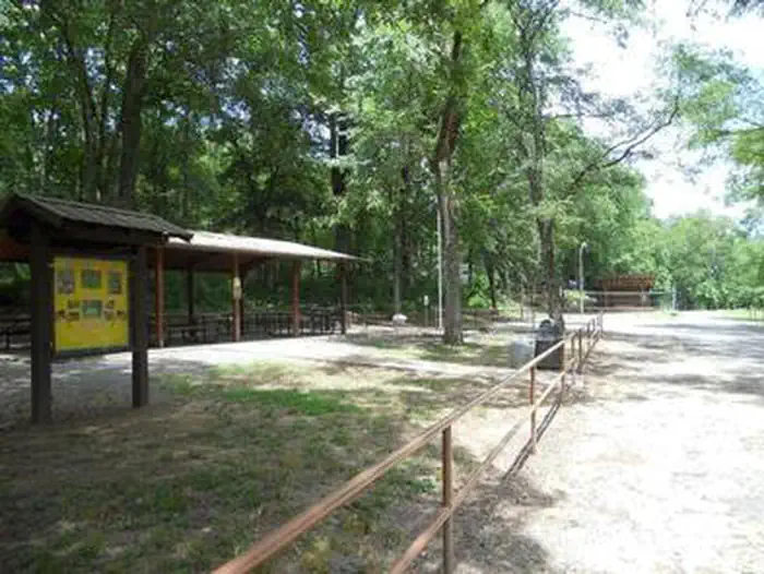
Cossatot Reefs offers 31 shady campsites, including a large group shelter. Hot showers, drinking water and flush toilets help create a comfortable camping experience.Natural Features
Gillham Lake spans 1,370 surface acres and boasts 36 miles of shoreline. The lake stems from the Cossatot River, designated as a National Wild and Scenic River.The facts
- 31 bookable sites
- 1 site for day use only
- 1 accessible site
- Vehicles up to 68 ft
- Up to 100 people per site
- Loops: COSSATOT REEFS
Site types
- 28 Standard Electric
- 2 Walk To
- 1 Group Shelter Electric
Amenities
- Electric hookups
- Water hookups
- Picnic tables
- Grills
- Shade
Not recorded upstream: sewer hookups, campfires allowed, fire pits, pets allowed.
31 campsites at Cossatot Reefs
| Site | Loop | Type | Entry | Surface | Water | Max rig | People | |
|---|---|---|---|---|---|---|---|---|
| 01 | COSSATOT REEFS | Standard Electric | Back In | Paved | — | 48 ft | 8 | |
| 02 | COSSATOT REEFS | Standard Electric | Back In | Paved | — | 50 ft | 8 | |
| 03 | COSSATOT REEFS | Standard Electric | Back In | Paved | — | 47 ft | 8 | |
| 04 | COSSATOT REEFS | Standard Electric | Back In | Paved | — | 62 ft | 8 | |
| 05 | COSSATOT REEFS | Standard Electric | Back In | Paved | — | 59 ft | 8 | |
| 06 | COSSATOT REEFS | Standard Electric | Back In | Paved | — | 64 ft | 8 | |
| 07 | COSSATOT REEFS | Standard Electric | Back In | Paved | — | 63 ft | 8 | |
| 08 | COSSATOT REEFS | Standard Electric | Back In | Paved | — | 55 ft | 8 | |
| 09 | COSSATOT REEFS | Standard Electric | Back In | Paved | — | 62 ft | 8 | |
| 10 | COSSATOT REEFS | Standard Electric | Back In | Paved | — | 57 ft | 8 | |
| 11 | COSSATOT REEFS | Standard Electric | Back In | Paved | — | 68 ft | 8 | |
| 12 | COSSATOT REEFS | Standard Electric | Back In | Paved | — | 57 ft | 8 | |
| 13 | COSSATOT REEFS | Standard Electric | Back In | Paved | — | 55 ft | 8 | |
| 14 | COSSATOT REEFS | Standard Electric | Back In | Paved | — | 64 ft | 8 | |
| 15 | COSSATOT REEFS | Standard Electric | Back In | Paved | — | 67 ft | 8 | |
| 16 | COSSATOT REEFS | Standard Electric | Back In | Paved | — | 58 ft | 8 | |
| 17 | COSSATOT REEFS | Standard Electric | Back In | Paved | — | 48 ft | 8 | |
| 18 | COSSATOT REEFS | Standard Electric | Back In | Paved | — | 30 ft | 8 | |
| 19 | COSSATOT REEFS | Standard Electric | Back In | Paved | — | 48 ft | 8 | |
| 20 | COSSATOT REEFS | Standard Electric | Back In | Paved | — | 57 ft | 8 | |
| 21 | COSSATOT REEFS | Standard Electric | Back In | Paved | — | 48 ft | 8 | |
| 22 | COSSATOT REEFS | Standard Electric | Back In | Paved | — | 58 ft | 8 | |
| 23 | COSSATOT REEFS | Standard Electric | Back In | Paved | — | 52 ft | 8 | |
| 24 | COSSATOT REEFS | Standard Electric | Back In | Paved | — | 39 ft | 8 | |
| 25 | COSSATOT REEFS | Standard Electric | Back In | Paved | — | 59 ft | 8 | |
| 26 | COSSATOT REEFS | Standard Electric | Back In | Paved | — | 49 ft | 8 | |
| 27 | COSSATOT REEFS | Walk To | Back In | Paved | — | — | 8 | |
| 28 | COSSATOT REEFS | Standard Electric | Back In | Paved | — | 48 ft | 8 | |
| 29 | COSSATOT REEFS | Walk To | Back In | Paved | — | — | 8 | |
| 30 | COSSATOT REEFS | Standard Electric | Back In | Paved | — | 53 ft | 8 | |
| GS1 | COSSATOT REEFS | Group Shelter Electric | Back In | Paved | Riverfront | 20 ft | 100 | ♿ |
Getting there
34.20674, -94.23132 · 34°12'24.3"N 94°13'52.7"W
Typical weather
Typically 93°F in Aug, down to 54°F in Jan.
| Jan | Feb | Mar | Apr | May | Jun | Jul | Aug | Sep | Oct | Nov | Dec | |
|---|---|---|---|---|---|---|---|---|---|---|---|---|
| High °F | 54 | 58 | 66 | 74 | 81 | 88 | 92 | 93 | 87 | 76 | 64 | 55 |
| Low °F | 30 | 33 | 41 | 48 | 58 | 67 | 71 | 70 | 63 | 50 | 40 | 33 |
| Precip in | 4.1 | 4.2 | 5.0 | 5.8 | 6.3 | 4.4 | 3.4 | 3.3 | 4.0 | 4.7 | 4.4 | 5.3 |
1991–2020 averages from the nearest NOAA station, 12.9 mi away — not measured at the facility itself, and elevation can make a real difference over that distance.
Map
More photos

Member photos
Common questions about Cossatot Reefs
- Can you reserve a site at Cossatot Reefs?
- Yes, Cossatot Reefs is reservable through Recreation.gov.
- How many campsites does Cossatot Reefs have?
- 31 sites.
- What is the maximum RV length at Cossatot Reefs?
- 68 ft. That is the longest vehicle the sites here are recorded as taking; individual sites may be shorter.
- Does Cossatot Reefs have hookups?
- Electric, Water.
Camping near Cossatot Reefs
- Big Coon Creek 1.3 mi · Campground · we watch it
- Little Coon Creek Park 2 mi · Campground · we watch it
- Jefferson Ridge 7.2 mi · Campground · we watch it
- Blue Ridge Park 8 mi · Campground · we watch it
- Horseshoe Bend (Dierks Lake) 9.2 mi · Campground · we watch it
- Bellah Mine 11.1 mi · Campground · we watch it
- Oak Grove (AR) 12 mi · Campground · we watch it
- Pine Ridge 12.9 mi · Campground · we watch it
- Big Coon Day Use Pass 1.4 mi · Activity pass
- Bellah Mine Day Use Pass 11.1 mi · Activity pass
- Oak Grove Day Use 12 mi · Activity pass
- Shady Lake 15.9 mi · Campground
Contact
- Phone 870-386-7261
- Book Recreation.gov
Recreation.gov last updated this record on 2026-08-11.
Facility information and photographs from Recreation.gov (RIDB). SpotOpened is not affiliated with Recreation.gov or any federal agency.
Comments