Bellah Mine
Campground · Arkansas · 25 bookable sites ·
Managed by the US Army Corps of Engineers
Dequeen Recreation Area (Recreation Area) · Open Access
- 25
- Bookable sites
- 120 ft
- Max rig length
- up to 50
- People per site
- 1
- Accessible site
- 494 ft
- Elevation
Overview
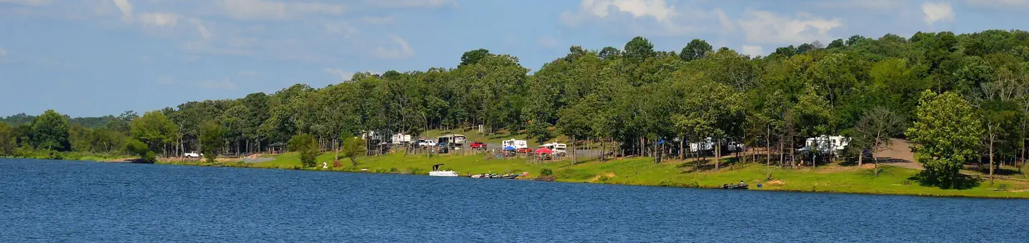
Bellah Mine Campground sits along the shores of DeQueen Lake in southwest Arkansas.Recreation
Boating and water sports top the list of recreational activities at the lake, and several boat ramps are provided for campers. Fishing is also a popular pastime, with large mouth bass, small mouth bass, spotted pass, black and white crappie, channel and flathead catfish and various species of sunfish available in abundance. The lake also has a WMA to allow hunting on the lands around the lake. Except for developed recreation areas and lands in the vicinity of the dam. Game species include bobwhite quail, mourning dove, turkey, fox squirrel, gray squirrel, cottontail rabbit and deer. De Queen Lake does have a designated hiking trail in Pine Ridge Park that is open to the public and hiking/biking activities are welcomed.
Facilities
Bellah Mine Campground offers 24 spacious campsites, along with one large reservable group picnic shelter. Campsites include modern amenities like flush toilets, showers and drinking water.Natural Features
DeQueen Lake is part of a dam project located on the Rolling Fork River. The dam, completed in 1977, was built for flood control and water supply, and now provides a recreational oasis for thousands of campers each year.The lake boasts 32 miles of shoreline to its visitors, along with 8,700 acres of rolling green landscape.
Nearby Attractions
The nearby town of DeQueen, Arkansas, offers gas, grocery and medical services.The facts
- 25 bookable sites
- 1 site for day use only
- 1 accessible site
- Vehicles up to 120 ft
- Up to 50 people per site
- Loops: BELLAH MINE
Site types
- 24 Standard Electric
- 1 Group Shelter Electric
Amenities
- Electric hookups
- Water hookups
- Campfires allowed
- Grills
- Shade
Not recorded upstream: sewer hookups, fire pits, picnic tables, pets allowed.
25 campsites at Bellah Mine
| Site | Loop | Type | Entry | Surface | Water | Max rig | People | |
|---|---|---|---|---|---|---|---|---|
| 01 | BELLAH MINE | Standard Electric | Back In | Paved | — | 20 ft | 8 | |
| 02 | BELLAH MINE | Standard Electric | Back In | Paved | — | 20 ft | 8 | |
| 03 | BELLAH MINE | Standard Electric | Pull Through | Paved | — | 95 ft | 8 | |
| 04 | BELLAH MINE | Standard Electric | Pull Through | Paved | — | 95 ft | 8 | |
| 05 | BELLAH MINE | Standard Electric | Pull Through | Paved | — | 95 ft | 8 | |
| 06 | BELLAH MINE | Standard Electric | Pull Through | Paved | — | 95 ft | 8 | |
| 07 | BELLAH MINE | Standard Electric | Pull Through | Paved | — | 95 ft | 8 | |
| 08 | BELLAH MINE | Standard Electric | Pull Through | Paved | — | 95 ft | 8 | |
| 09 | BELLAH MINE | Standard Electric | Back In | Paved | — | 82 ft | 8 | |
| 10 | BELLAH MINE | Standard Electric | Back In | Paved | — | 85 ft | 8 | |
| 11 | BELLAH MINE | Standard Electric | Back In | Paved | — | 70 ft | 8 | |
| 12 | BELLAH MINE | Standard Electric | Back In | Paved | — | 54 ft | 8 | |
| 13 | BELLAH MINE | Standard Electric | Back In | Paved | Lakefront | 60 ft | 8 | |
| 14 | BELLAH MINE | Standard Electric | Back In | Paved | — | 68 ft | 8 | |
| 15 | BELLAH MINE | Standard Electric | Back In | Paved | Lakefront | 85 ft | 8 | |
| 16 | BELLAH MINE | Standard Electric | Back In | Paved | — | 65 ft | 8 | |
| 17 | BELLAH MINE | Standard Electric | Pull Through | Paved | — | 86 ft | 8 | |
| 18 | BELLAH MINE | Standard Electric | Pull Through | Paved | — | 75 ft | 8 | |
| 19 | BELLAH MINE | Standard Electric | Back In | Paved | — | 66 ft | 8 | |
| 20 | BELLAH MINE | Standard Electric | Back In | Paved | — | 120 ft | 8 | |
| 21 | BELLAH MINE | Standard Electric | Back In | Paved | Lakefront | 68 ft | 8 | |
| 22 | BELLAH MINE | Standard Electric | Back In | Paved | Lakefront | 78 ft | 8 | |
| 23 | BELLAH MINE | Standard Electric | Pull Through | Paved | Lakefront | 66 ft | 8 | |
| 24 | BELLAH MINE | Standard Electric | Pull Through | Paved | Lakefront | 95 ft | 8 | |
| S01 | BELLAH MINE | Group Shelter Electric | — | Paved | — | — | 50 | ♿ |
Getting there
34.12720, -94.40049 · 34°7'37.9"N 94°24'1.8"W
Typical weather
Typically 93°F in Aug, down to 55°F in Jan.
| Jan | Feb | Mar | Apr | May | Jun | Jul | Aug | Sep | Oct | Nov | Dec | |
|---|---|---|---|---|---|---|---|---|---|---|---|---|
| High °F | 55 | 59 | 67 | 75 | 82 | 89 | 93 | 93 | 88 | 77 | 65 | 56 |
| Low °F | 31 | 35 | 42 | 50 | 60 | 68 | 71 | 70 | 63 | 51 | 40 | 34 |
| Precip in | 2.9 | 3.3 | 4.0 | 4.7 | 5.1 | 4.3 | 3.0 | 2.6 | 3.4 | 3.8 | 3.2 | 4.2 |
1991–2020 averages from the nearest NOAA station, 5.3 mi away — not measured at the facility itself, and elevation can make a real difference over that distance.
Map
More photos
Member photos
Common questions about Bellah Mine
- Can you reserve a site at Bellah Mine?
- Yes, Bellah Mine is reservable through Recreation.gov.
- How many campsites does Bellah Mine have?
- 25 sites.
- What is the maximum RV length at Bellah Mine?
- 120 ft. That is the longest vehicle the sites here are recorded as taking; individual sites may be shorter.
- Does Bellah Mine have hookups?
- Electric, Water.
- Are campfires allowed at Bellah Mine?
- Campfires are allowed at Bellah Mine. Check for a current fire restriction before you go.
Camping near Bellah Mine
- Oak Grove (AR) 2.1 mi · Campground · we watch it
- Pine Ridge 2.2 mi · Campground · we watch it
- Big Coon Creek 11.1 mi · Campground · we watch it
- Little Coon Creek Park 11.1 mi · Campground · we watch it
- Cossatot Reefs 11.1 mi · Campground · we watch it
- Jefferson Ridge 15.7 mi · Campground · we watch it
- Horseshoe Bend (Dierks Lake) 17.9 mi · Campground · we watch it
- Blue Ridge Park 18.2 mi · Campground · we watch it
- Bellah Mine Day Use Pass less than 0.1 mi · Activity pass
- Oak Grove Day Use 2.1 mi · Activity pass
- Big Coon Day Use Pass 11 mi · Activity pass
- Shady Lake 26.8 mi · Campground
Contact
- Phone 870 386 7511
- Book Recreation.gov
Recreation.gov last updated this record on 2026-08-11.
Facility information and photographs from Recreation.gov (RIDB). SpotOpened is not affiliated with Recreation.gov or any federal agency.
Comments