Houston Shelter
Campground · Alabama · 1 bookable site ·
Managed by the USDA Forest Service
William B. Bankhead National Forest (NF) · Open Access
- 1
- Bookable site
- up to 50
- People per site
- 605 ft
- Elevation
Overview
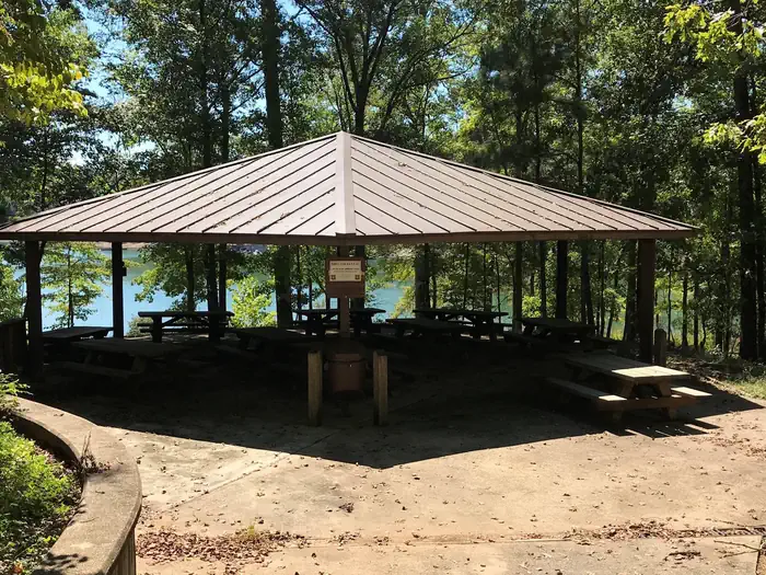
Houston Shelter is a group picnic site nestled on the shore of Lake Lewis Smith in Bankhead National Forest. This is a popular recreation area offering a variety of activities. Shelter is first come first served. Site is walk-up only.Recreation
Day users can enjoy a beautiful sand swimming beach. Other activities include motorized and non-motorized boating and water skiing.Anglers can fish for Kentucky Spotted Bass and Hybrid Striped Bass. There are also hiking trails in the area, including the 1.4 mile High Rock Loop and the nearly 2 mile Fox Run Loop.
Facilities
The picnic facility offers tables, flush toilets, grills and drinking water. A boat ramp and showers are nearby.Natural Features
Bankhead National Forest is located in northwestern Alabama. The prominent feature of the area is the Sipsey Wilderness.Known as "The Land of a Thousand Waterfalls," the Sipsey Wilderness encompasses an area of abundant streams, old-growth forests, limestone bluffs and lush canyons.
Lake Lewis Smith boasts more than 500 miles of shoreline marked by high rock bluffs. The water is clear and deep and provides excellent fishing.
The facts
- 1 bookable site
- 1 site for day use only
- Up to 50 people per site
- Loops: HOUS
Site types
- 1 Group Shelter Nonelectric
Amenities
- Water hookups
- Picnic tables
- Shade
- Pets allowed
Not recorded upstream: electric hookups, sewer hookups, campfires allowed, fire pits, grills.
1 campsite at Houston Shelter
Check-in 7:00 AM · Check-out 10:00 PM
| Site | Loop | Type | Entry | Surface | Max rig | People | |
|---|---|---|---|---|---|---|---|
| 1 | HOUS | Group Shelter Nonelectric | — | Paved | — | 50 | 🐾 |
Getting there
34.12444, -87.29806 · 34°7'28.0"N 87°17'53.0"W
Typical weather
| Jan | Feb | Mar | Apr | May | Jun | Jul | Aug | Sep | Oct | Nov | Dec | |
|---|---|---|---|---|---|---|---|---|---|---|---|---|
| High °F | — | — | — | — | — | — | — | — | — | — | — | — |
| Low °F | — | — | — | — | — | — | — | — | — | — | — | — |
| Precip in | 5.8 | 5.9 | 5.8 | 5.9 | 5.0 | 5.0 | 5.1 | 4.3 | 4.2 | 4.3 | 4.6 | 6.7 |
1991–2020 averages from the nearest NOAA station, 7.1 mi away — not measured at the facility itself, and elevation can make a real difference over that distance.
Map
Fees and stay limits
The Houston Recreation Area Shelter is non-reservable but available on a first-come, first-served basis. The use fee is $20.00 per day, plus $4.00 per vehicle deposited in the fee tube at the Houston Recreation Area entrance.
From Recreation.gov, which is not always current. The operator's own page is the authority on what you will be charged.
Member photos
Common questions about Houston Shelter
- Can you reserve a site at Houston Shelter?
- Yes, Houston Shelter is reservable through Recreation.gov.
- How many campsites does Houston Shelter have?
- 1 site.
- Are pets allowed at Houston Shelter?
- Yes, pets are allowed at Houston Shelter.
- Does Houston Shelter have hookups?
- Water.
Camping near Houston Shelter
- Corinth Recreation Area 1.8 mi · Campground · we watch it
- Clear Creek (Al) 7.3 mi · Campground · we watch it
- Burchfield Branch Park 47.5 mi · Campground · we watch it
- Rocky Branch Day Use Park 59.2 mi · Campground · we watch it
- Houston Recreation Area 0.2 mi · Facility
- Natural Bridge Picnic Area 3.7 mi · Facility
- Brushy Lake Recreation Area 12 mi · Facility
- Owl Creek Horse Camp 14.2 mi · Facility
- Temporary Visitor Center (Birmingham Civil Rights Institute) 50.4 mi · Visitor Center
- A.G. Gaston Motel (Temporarily Closed) 50.4 mi · Visitor Center
Contact
- Phone 205-489-5111
- Book Recreation.gov
Recreation.gov last updated this record on 2026-02-25.
Facility information and photographs from Recreation.gov (RIDB). SpotOpened is not affiliated with Recreation.gov or any federal agency.
Comments